Bouillé-Loretz (Bouillé-Loretz)

- commune in Deux-Sèvres, France
- Country:

- Postal Code: 79290
- Coordinates: 47° 4' 44" N, 0° 16' 21" E


- GPS tracks (wikiloc): [Link]
- Area: 26.78 sq km
- Population: 1058
- Web site: http://www.bouille-loretz.notremairie.fr/
- Wikipedia en: wiki(en)
- Wikipedia: wiki(fr)
- Wikidata storage: Wikidata: Q1344233
- Wikipedia Commons Category: [Link]
- Freebase ID: [/m/03mg1r9]
- GeoNames ID: Alt: [3031238]
- SIREN number: [217900430]
- BnF ID: [15276179n]
- VIAF ID: Alt: [136180919]
- Library of Congress authority ID: Alt: [n91085643]
- PACTOLS thesaurus ID: [pcrtheDXUGdtmJ]
- INSEE municipality code: 79043
Shares border with regions:

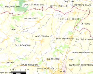
Argenton-l'Église
- commune in Deux-Sèvres, France
- Country:
- Postal Code: 79290
- Coordinates: 47° 2' 38" N, 0° 15' 38" E
- GPS tracks (wikiloc): [Link]
- Area: 25.86 sq km
- Population: 1638
Bouillé-Saint-Paul
- former commune in Deux-Sèvres, France
- Country:
- Postal Code: 79290
- Coordinates: 47° 1' 31" N, 0° 20' 46" E
- GPS tracks (wikiloc): [Link]
- Area: 20.38 sq km
- Population: 402

Saint-Macaire-du-Bois
- commune in Maine-et-Loire, France
- Country:
- Postal Code: 49260
- Coordinates: 47° 7' 5" N, 0° 16' 32" E
- GPS tracks (wikiloc): [Link]
- Area: 13.06 sq km
- Population: 457
- Web site: [Link]

Saint-Martin-de-Sanzay
- commune in Deux-Sèvres, France
- Country:
- Postal Code: 79290
- Coordinates: 47° 4' 52" N, 0° 11' 57" E
- GPS tracks (wikiloc): [Link]
- Area: 24.69 sq km
- Population: 1059
- Web site: [Link]
Nueil-sur-Layon
- former commune in Maine-et-Loire, France
- Country:
- Postal Code: 49560
- Coordinates: 47° 7' 5" N, 0° 22' 0" E
- GPS tracks (wikiloc): [Link]
- Area: 61.23 sq km
- Population: 1329
- Web site: [Link]
Cersay
- former commune in Deux-Sèvres, France
- Country:
- Postal Code: 79290
- Coordinates: 47° 2' 47" N, 0° 21' 15" E
- GPS tracks (wikiloc): [Link]
- Area: 36.78 sq km
- Population: 703


Le Puy-Notre-Dame
- commune in Maine-et-Loire, France
- Country:
- Postal Code: 49260
- Coordinates: 47° 7' 31" N, 0° 14' 6" E
- GPS tracks (wikiloc): [Link]
- Area: 16.04 sq km
- Population: 1201
- Web site: [Link]