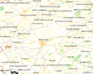
arrondissement of Bressuire (arrondissement de Bressuire)
- arrondissement of France
- Country:

- Capital: Bressuire
- Coordinates: 46° 55' 0" N, 0° 30' 0" E


- GPS tracks (wikiloc): [Link]
- Area: 1623 sq km
- Population: 96748
- Wikipedia en: wiki(en)
- Wikipedia: wiki(fr)
- Wikidata storage: Wikidata: Q629410
- Freebase ID: [/m/095f_c]
- GeoNames ID: Alt: [3030302]
- INSEE arrondissement code: [791]
- GNS Unique Feature ID: -1415034
Includes regions:


canton of Cerizay
- canton of France
- Country:

- Capital: Cerizay
- Coordinates: 46° 48' 59" N, 0° 38' 50" E


- GPS tracks (wikiloc): [Link]
- Population: 26166
canton of Saint-Varent
- canton of France (until March 2015)
- Country:

- Capital: Saint-Varent
- Coordinates: 46° 53' 50" N, 0° 17' 30" E


- GPS tracks (wikiloc): [Link]


Bressuire
- commune in Deux-Sèvres, France
- Country:

- Postal Code: 79300
- Coordinates: 46° 50' 24" N, 0° 29' 19" E


- GPS tracks (wikiloc): [Link]
- AboveSeaLevel: 166 м m
- Area: 180.59 sq km
- Population: 19411
- Web site: [Link]


canton of Bressuire
- canton of France
- Country:

- Capital: Bressuire
- Coordinates: 46° 48' 38" N, 0° 24' 32" E


- GPS tracks (wikiloc): [Link]
- Population: 23898


canton of Mauléon
- canton of France
- Country:

- Capital: Mauléon
- Coordinates: 46° 55' 11" N, 0° 43' 21" E


- GPS tracks (wikiloc): [Link]
- Area: 523.55 sq km
- Population: 23364

canton of Argenton-les-Vallées
- canton of France (until March 2015)
- Country:

- Capital: Argenton-les-Vallées
- Coordinates: 46° 59' 8" N, 0° 26' 54" E


- GPS tracks (wikiloc): [Link]

