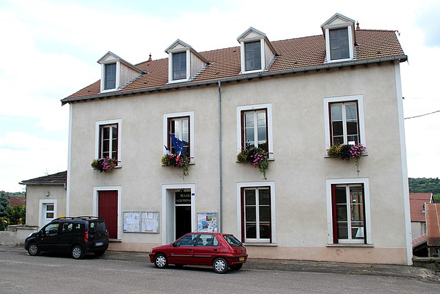
Bourbonne-les-Bains (Bourbonne-les-Bains)

- commune in Haute-Marne, France
- Country:

- Postal Code: 52400
- Coordinates: 47° 57' 14" N, 5° 44' 58" E


- GPS tracks (wikiloc): [Link]
- AboveSeaLevel: 282 м m
- Area: 64.93 sq km
- Population: 2118
- Web site: http://www.bourbonne.com/
- Wikipedia en: wiki(en)
- Wikipedia: wiki(fr)
- Wikidata storage: Wikidata: Q627061
- Wikipedia Commons Category: [Link]
- Freebase ID: [/m/04y7tx]
- Freebase ID: [/m/04y7tx]
- GeoNames ID: Alt: [3031086]
- GeoNames ID: Alt: [3031086]
- SIREN number: [215200403]
- SIREN number: [215200403]
- BnF ID: [152633109]
- BnF ID: [152633109]
- VIAF ID: Alt: [144164570]
- VIAF ID: Alt: [144164570]
- GND ID: Alt: [4080496-3]
- GND ID: Alt: [4080496-3]
- Library of Congress authority ID: Alt: [n82099842]
- Library of Congress authority ID: Alt: [n82099842]
- PACTOLS thesaurus ID: [pcrtaYyPk0mPDD]
- PACTOLS thesaurus ID: [pcrtaYyPk0mPDD]
- SUDOC authorities ID: [113795114]
- SUDOC authorities ID: [113795114]
- Pleiades ID: [177476]
- Pleiades ID: [177476]
- INSEE municipality code: 52060
- INSEE municipality code: 52060
Shares border with regions:

Fresnes-sur-Apance
- commune in Haute-Marne, France
- Country:
- Postal Code: 52400
- Coordinates: 47° 56' 28" N, 5° 50' 5" E
- GPS tracks (wikiloc): [Link]
- Area: 16.47 sq km
- Population: 158


Coiffy-le-Bas
- commune in Haute-Marne, France
- Country:
- Postal Code: 52400
- Coordinates: 47° 54' 51" N, 5° 40' 38" E
- GPS tracks (wikiloc): [Link]
- AboveSeaLevel: 280 м m
- Area: 11.32 sq km
- Population: 94


Senaide
- commune in Vosges, France
- Country:
- Postal Code: 88320
- Coordinates: 47° 58' 14" N, 5° 48' 12" E
- GPS tracks (wikiloc): [Link]
- Area: 12.17 sq km
- Population: 178
Laneuvelle
- commune in Haute-Marne, France
- Country:
- Postal Code: 52400
- Coordinates: 47° 55' 27" N, 5° 40' 18" E
- GPS tracks (wikiloc): [Link]
- Area: 11.03 sq km
- Population: 72


Le Châtelet-sur-Meuse
- commune in Haute-Marne, France
- Country:
- Postal Code: 52400
- Coordinates: 47° 58' 58" N, 5° 37' 39" E
- GPS tracks (wikiloc): [Link]
- AboveSeaLevel: 409 м m
- Area: 21.31 sq km
- Population: 159

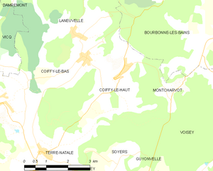
Coiffy-le-Haut
- commune in Haute-Marne, France
- Country:
- Postal Code: 52400
- Coordinates: 47° 54' 31" N, 5° 41' 58" E
- GPS tracks (wikiloc): [Link]
- AboveSeaLevel: 420 м m
- Area: 9.65 sq km
- Population: 123


Voisey
- commune in Haute-Marne, France
- Country:
- Postal Code: 52400
- Coordinates: 47° 53' 4" N, 5° 46' 56" E
- GPS tracks (wikiloc): [Link]
- Area: 31.6 sq km
- Population: 297

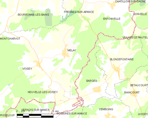
Melay
- commune in Haute-Marne, France
- Country:
- Postal Code: 52400
- Coordinates: 47° 53' 30" N, 5° 48' 43" E
- GPS tracks (wikiloc): [Link]
- Area: 13.95 sq km
- Population: 266
- Web site: [Link]


Montcharvot
- commune in Haute-Marne, France
- Country:
- Postal Code: 52400
- Coordinates: 47° 54' 5" N, 5° 43' 49" E
- GPS tracks (wikiloc): [Link]
- Area: 3.52 sq km
- Population: 35


Serqueux
- commune in Haute-Marne, France
- Country:
- Postal Code: 52400
- Coordinates: 47° 59' 27" N, 5° 44' 14" E
- GPS tracks (wikiloc): [Link]
- Area: 25.63 sq km
- Population: 436
- Web site: [Link]