Bourguenolles (Bourguenolles)

- commune in Manche, France
- Country:

- Postal Code: 50800
- Coordinates: 48° 48' 15" N, 1° 17' 52" E


- GPS tracks (wikiloc): [Link]
- Area: 7.65 sq km
- Population: 340
- Wikipedia en: wiki(en)
- Wikipedia: wiki(fr)
- Wikidata storage: Wikidata: Q430350
- Wikipedia Commons Category: [Link]
- Freebase ID: [/m/03qcqb5]
- Freebase ID: [/m/03qcqb5]
- GeoNames ID: Alt: [6449485]
- GeoNames ID: Alt: [6449485]
- SIREN number: [215000696]
- SIREN number: [215000696]
- BnF ID: [15262047k]
- BnF ID: [15262047k]
- INSEE municipality code: 50069
- INSEE municipality code: 50069
Shares border with regions:


La Lande-d'Airou
- commune in Manche, France
- Country:
- Postal Code: 50800
- Coordinates: 48° 48' 58" N, 1° 17' 25" E
- GPS tracks (wikiloc): [Link]
- Area: 15.1 sq km
- Population: 514


Le Tanu
- commune in Manche, France
- Country:
- Postal Code: 50320
- Coordinates: 48° 48' 59" N, 1° 20' 43" E
- GPS tracks (wikiloc): [Link]
- Area: 10.12 sq km
- Population: 376


La Trinité
- commune in Manche, France
- Country:
- Postal Code: 50800
- Coordinates: 48° 47' 26" N, 1° 14' 7" E
- GPS tracks (wikiloc): [Link]
- Area: 9.16 sq km
- Population: 400

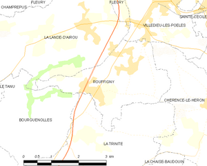
Rouffigny
- former commune in Manche, France
- Country:
- Postal Code: 50800
- Coordinates: 48° 48' 13" N, 1° 15' 14" E
- GPS tracks (wikiloc): [Link]
- Area: 6.72 sq km
- Population: 308