Boz (Boz)
- commune in Ain, France
- Country:

- Postal Code: 01190
- Coordinates: 46° 24' 25" N, 4° 54' 34" E


- GPS tracks (wikiloc): [Link]
- Area: 7.31 sq km
- Population: 516
- Web site: http://communeboz.fr
- Wikipedia en: wiki(en)
- Wikipedia: wiki(fr)
- Wikidata storage: Wikidata: Q598434
- Wikipedia Commons Category: [Link]
- Wikipedia Commons Maps Category: [Link]
- Freebase ID: [/m/07ttjb]
- Freebase ID: [/m/07ttjb]
- GeoNames ID: Alt: [6446398]
- GeoNames ID: Alt: [6446398]
- SIREN number: [210100574]
- SIREN number: [210100574]
- INSEE municipality code: 01057
- INSEE municipality code: 01057
Shares border with regions:

Ozan
- commune in Ain, France
- Country:
- Postal Code: 01190
- Coordinates: 46° 23' 30" N, 4° 54' 56" E
- GPS tracks (wikiloc): [Link]
- Area: 6.6 sq km
- Population: 668


La Salle
- commune in Saône-et-Loire, France
- Country:
- Postal Code: 71260
- Coordinates: 46° 24' 30" N, 4° 52' 11" E
- GPS tracks (wikiloc): [Link]
- Area: 5.67 sq km
- Population: 552
- Web site: [Link]


Saint-Albain
- commune in Saône-et-Loire, France
- Country:
- Postal Code: 71260
- Coordinates: 46° 25' 41" N, 4° 52' 37" E
- GPS tracks (wikiloc): [Link]
- Area: 5.64 sq km
- Population: 500
- Web site: [Link]


Asnières-sur-Saône
- commune in Ain, France
- Country:
- Postal Code: 01570
- Coordinates: 46° 23' 2" N, 4° 52' 59" E
- GPS tracks (wikiloc): [Link]
- Area: 4.68 sq km
- Population: 64

Reyssouze
- commune in Ain, France
- Country:
- Postal Code: 01190
- Coordinates: 46° 25' 55" N, 4° 55' 9" E
- GPS tracks (wikiloc): [Link]
- Area: 9.54 sq km
- Population: 970

Chevroux
- commune in Ain, France
- Country:
- Postal Code: 01190
- Coordinates: 46° 22' 50" N, 4° 56' 55" E
- GPS tracks (wikiloc): [Link]
- Area: 17.2 sq km
- Population: 964
- Web site: [Link]

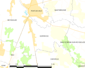
Gorrevod
- commune in Ain, France
- Country:
- Postal Code: 01190
- Coordinates: 46° 24' 57" N, 4° 56' 28" E
- GPS tracks (wikiloc): [Link]
- Area: 6.88 sq km
- Population: 854


Senozan
- commune in Saône-et-Loire, France
- Country:
- Postal Code: 71260
- Coordinates: 46° 23' 39" N, 4° 51' 58" E
- GPS tracks (wikiloc): [Link]
- Area: 4.86 sq km
- Population: 1119
- Web site: [Link]