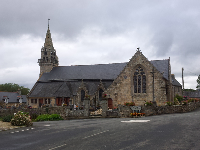
Brélidy (Brélidy)

- commune in Côtes-d'Armor, France
- Country:

- Postal Code: 22140
- Coordinates: 48° 39' 34" N, 3° 13' 5" E


- GPS tracks (wikiloc): [Link]
- Area: 8.14 sq km
- Population: 298
- Web site: http://www.pontrieuxcommunaute.com/brelidy.asp
- Wikipedia en: wiki(en)
- Wikipedia: wiki(fr)
- Wikidata storage: Wikidata: Q654246
- Wikipedia Commons Category: [Link]
- Freebase ID: [/m/03hjmrd]
- GeoNames ID: Alt: [6447632]
- SIREN number: [212200182]
- BnF ID: [152510203]
- INSEE municipality code: 22018
Shares border with regions:

Landebaëron
- commune in Côtes-d'Armor, France
- Country:
- Postal Code: 22140
- Coordinates: 48° 38' 4" N, 3° 12' 33" E
- GPS tracks (wikiloc): [Link]
- Area: 6.44 sq km
- Population: 187

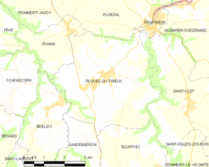
Plouëc-du-Trieux
- commune in Côtes-d'Armor, France
- Country:
- Postal Code: 22260
- Coordinates: 48° 41' 0" N, 3° 12' 0" E
- GPS tracks (wikiloc): [Link]
- Area: 18.27 sq km
- Population: 1131
- Web site: [Link]


Bégard
- commune in Côtes-d'Armor, France
- Country:
- Postal Code: 22140
- Coordinates: 48° 37' 41" N, 3° 18' 3" E
- GPS tracks (wikiloc): [Link]
- Area: 36.41 sq km
- Population: 4752
- Web site: [Link]


Runan
- commune in Côtes-d'Armor, France
- Country:
- Postal Code: 22260
- Coordinates: 48° 41' 36" N, 3° 12' 42" E
- GPS tracks (wikiloc): [Link]
- Area: 5.12 sq km
- Population: 227
- Web site: [Link]


Saint-Laurent
- commune in Côtes-d'Armor, France
- Country:
- Postal Code: 22140
- Coordinates: 48° 37' 8" N, 3° 13' 57" E
- GPS tracks (wikiloc): [Link]
- AboveSeaLevel: 115 м m
- Area: 8.96 sq km
- Population: 500

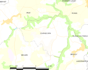
Coatascorn
- commune in Côtes-d'Armor, France
- Country:
- Postal Code: 22140
- Coordinates: 48° 40' 26" N, 3° 15' 1" E
- GPS tracks (wikiloc): [Link]
- Area: 8.05 sq km
- Population: 251