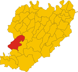
Brallo di Pregola (Brallo di Pregola)
.svg)
- Italian comune
 Hiking in Brallo di Pregola
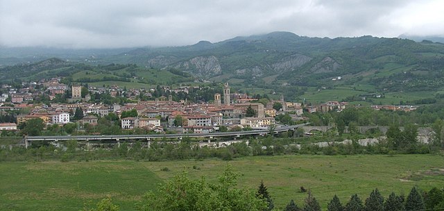
Brallo di Pregola is a small town in the Lombardy region of northern Italy, surrounded by beautiful natural landscapes that make it a great destination for hiking enthusiasts. Located in the Oltrepò Pavese area, it offers a mix of rolling hills, lush forests, and panoramic views. Here are some key points to consider when planning a hike in Brallo di Pregola:
Trails and Paths
-
Diverse Trails: The area features a variety of hiking trails ranging from easy walks suitable for families to more challenging hikes for experienced trekkers. Always check local maps for trail routes.
-
Sentieri (Paths): The region is crisscrossed with well-marked paths, such as the Sentiero dei Parchi, which connects various parks and natural reserves. These paths often lead through scenic landscapes and historical sites.
-
Nature Reserves: Close by, you can access natural parks like the Parco Naturale dell'Antola and the Parco Regionale del Monte Penerone, where you can hike among diverse flora and fauna.
What to See
-
Panoramic Views: Many trails lead to viewpoints where you can appreciate the rolling hills of the Apennines and, on clear days, views of the Po Valley.
-
Historical Sites: Some trails may take you near historical locations, including ancient ruins, churches, and small villages, providing a glimpse into local culture.
-
Wildlife: The area is home to various wildlife species, so keep an eye out for deer, foxes, and numerous bird species while you hike.
Hiking Tips
-
Weather Awareness: The weather can change rapidly in the mountains. Be sure to check the forecast and dress in layers to ensure you're comfortable.
-
Stay Hydrated: Carry sufficient water and snacks, especially on longer hikes, to maintain your energy levels.
-
Trail Etiquette: Respect the natural environment by staying on designated trails, not disturbing wildlife, and carrying out any trash you bring in.
-
Local Guidance: If you are unfamiliar with the area, consider hiring a local guide who can provide insights into the trails and help ensure a safe experience.
-
Emergency Preparedness: Have a fully charged phone, a map, and a first aid kit handy in case of emergencies.
Best Time to Hike
The ideal seasons for hiking in Brallo di Pregola are spring (April to June) and early autumn (September to October). These times typically offer mild temperatures and vibrant landscapes, making for a pleasant hiking experience. Summer can be hot, and winter may present snow-covered trails.
With its beautiful natural scenery and variety of trails, Brallo di Pregola is a fantastic destination for hikers seeking both adventure and tranquility in Italy's countryside.
- Country:

- Postal Code: 27050
- Local Dialing Code: 0383
- Licence Plate Code: PV
- Coordinates: 44° 44' 0" N, 9° 17' 0" E


- GPS tracks (wikiloc): [Link]
- AboveSeaLevel: 951 м m
- Area: 46.15 sq km
- Population: 580
- Web site: http://www.comune.brallodipregola.pv.it
- Wikipedia en: wiki(en)
- Wikipedia: wiki(it)
- Wikidata storage: Wikidata: Q39799
- Wikipedia Commons Category: [Link]
- Freebase ID: [/m/0gjh0c]
- GeoNames ID: Alt: [6541547]
- OSM relation ID: [43482]
- ISTAT ID: 018021
- Italian cadastre code: B117
Shares border with regions:
Cerignale
- Italian comune
Hiking in Cerignale
Cerignale is a charming village located in the Apennine Mountains of northern Italy, within the region of Emilia-Romagna. This area is known for its stunning landscapes, rich wildlife, and numerous hiking opportunities, making it an excellent destination for outdoor enthusiasts. Here are some highlights and tips for hiking in Cerignale:...
- Country:
- Postal Code: 29020
- Local Dialing Code: 0523
- Licence Plate Code: PC
- Coordinates: 44° 41' 0" N, 9° 21' 0" E
- GPS tracks (wikiloc): [Link]
- AboveSeaLevel: 725 м m
- Area: 30.82 sq km
- Population: 123
- Web site: [Link]


Corte Brugnatella
- Italian comune
Hiking in Corte Brugnatella
Corte Brugnatella is a charming municipality located in the province of Piacenza, in the Emilia-Romagna region of Italy. This area offers a fantastic range of hiking opportunities, thanks to its picturesque landscapes, rolling hills, and rich natural beauty. Here are a few key points to consider for hiking in and around Corte Brugnatella:...
- Country:
- Postal Code: 29020
- Local Dialing Code: 0523
- Licence Plate Code: PC
- Coordinates: 44° 41' 45" N, 9° 23' 7" E
- GPS tracks (wikiloc): [Link]
- AboveSeaLevel: 476 м m
- Area: 46.31 sq km
- Population: 580
- Web site: [Link]


Ottone
- Italian comune
Hiking in Ottone
Ottone is a small municipality located in the province of Piacenza, in the picturesque region of Emilia-Romagna, Italy. Known for its stunning landscapes, Ottone offers numerous opportunities for hiking enthusiasts to explore its natural beauty, rich biodiversity, and charming rural landscapes....
- Country:
- Postal Code: 29026
- Local Dialing Code: 0523
- Licence Plate Code: PC
- Coordinates: 44° 37' 0" N, 9° 20' 0" E
- GPS tracks (wikiloc): [Link]
- AboveSeaLevel: 510 м m
- Area: 98.96 sq km
- Population: 495
- Web site: [Link]
Zerba
- Italian comune
Hiking in Zerba
Zerba is a charming village located in the Apennine Mountains of Italy, specifically in the Emilia-Romagna region. The area offers some fantastic hiking opportunities, characterized by stunning landscapes, diverse flora, and views of the surrounding mountains and valleys....
- Country:
- Postal Code: 29020
- Local Dialing Code: 0523
- Licence Plate Code: PC
- Coordinates: 44° 39' 56" N, 9° 17' 17" E
- GPS tracks (wikiloc): [Link]
- AboveSeaLevel: 906 м m
- Area: 24.13 sq km
- Population: 77
- Web site: [Link]
Bobbio
- Italian comune
Hiking in Bobbio
Bobbio is a charming town located in the Emilia-Romagna region of northern Italy, surrounded by the beautiful landscape of the Apennine Mountains. This area is rich in natural beauty, history, and opportunities for outdoor activities, making it an appealing destination for hiking enthusiasts....
- Country:
- Postal Code: 29022
- Local Dialing Code: 0523
- Licence Plate Code: PC
- Coordinates: 44° 46' 17" N, 9° 23' 11" E
- GPS tracks (wikiloc): [Link]
- AboveSeaLevel: 272 м m
- Area: 106.53 sq km
- Population: 3589
- Web site: [Link]


Santa Margherita di Staffora
- Italian comune
Hiking in Santa Margherita di Staffora
Santa Margherita di Staffora is a charming village located in the Province of Pavia, in the Lombardy region of northern Italy. Nestled in the scenic Staffora Valley in the Appennino Pavese, it offers a variety of hiking opportunities, characterized by beautiful landscapes, wooded trails, and panoramic views of the surrounding mountains....
- Country:
- Postal Code: 27050
- Local Dialing Code: 0383
- Licence Plate Code: PV
- Coordinates: 44° 44' 0" N, 9° 17' 0" E
- GPS tracks (wikiloc): [Link]
- AboveSeaLevel: 550 м m
- Area: 36.9 sq km
- Population: 478
- Web site: [Link]