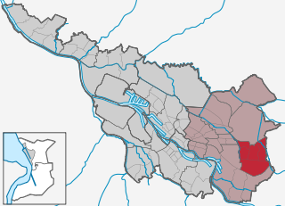
Bremen-Ost (Stadtbezirk 3 Ost (Bremen))

- one of 5 administrative districts of Bremen, Germany
 Hiking in Bremen-Ost
Bremen-Ost, a district in the city of Bremen, Germany, offers a variety of opportunities for hiking and outdoor activities, although it may not be as renowned for hiking as some larger national parks or mountain regions. Here are some options and features to consider if you're looking to hike in and around Bremen-Ost:
-
Parks and Green Spaces: Bremen-Ost is home to several parks and green spaces where you can enjoy walking and casual hikes. The Bürgerpark and various smaller parks within the district provide scenic routes and a chance to immerse yourself in nature without leaving the city.
-
Flat Terrain: The area generally features flat terrain, which makes it accessible for all skill levels, including families with children and individuals who may prefer a more leisurely pace.
-
Biking and Walking Trails: Many trails in the region cater to both walkers and cyclists. While not specifically hiking trails, these routes can provide a fulfilling outdoor experience and are often well-marked.
-
Nearby Nature Areas: If you're willing to venture a bit outside Bremen-Ost, the larger Bremen region has more extensive walking and hiking options. Areas like the Wümme river valley and the surrounding nature reserves offer picturesque landscapes and varied flora and fauna.
-
Cultural Sites: While hiking, you might also come across some cultural and historical sites within Bremen-Ost, making your outing enriching from both a natural and cultural perspective.
-
Transportation: Bremen's public transport makes it easy to access more expansive hiking areas around the city. Consider taking a short train or bus ride to nearby nature reserves or more rural landscapes.
Tips for Hiking in Bremen-Ost:
- Prepare for Weather: Make sure to check the weather forecast, as conditions can change, and bring appropriate clothing.
- Stay on Marked Trails: If you're exploring less urban areas, stick to marked paths to avoid trespassing on private property or disturbing wildlife.
- Hydrate and Snack: Carry enough water and some snacks, especially if you plan to hike for a longer period.
- Respect Nature: Follow the Leave No Trace principles to preserve the natural beauty of the area for future hikers.
Whether you choose to enjoy the tranquility of local parks or explore further out into the surrounding nature, Bremen-Ost offers pleasant spots for outdoor activities.
- Country:

- Wikidata storage: Wikidata: Q30147400
- Wikipedia Commons Category: [Link]
Includes regions:


Horn-Lehe
- human settlement
Hiking in Horn-Lehe
Horn-Lehe is a district in the city of Bremen, Germany. While it may not be widely known for extensive hiking trails like more mountainous regions, there are still opportunities for pleasant walks and exploring nature within and around the area....
- Country:
- Coordinates: 53° 5' 50" N, 8° 52' 12" E


- GPS tracks (wikiloc): [Link]

Osterholz
- quarter of Bremen
Hiking in Osterholz
Osterholz, located near Bremen, Germany, is not only a charming area known for its rich history and culture but also offers some lovely hiking opportunities for outdoor enthusiasts....
- Country:
- Coordinates: 53° 3' 31" N, 8° 56' 19" E
- GPS tracks (wikiloc): [Link]


Vahr
- human settlement in Germany
Hiking in Vahr
Vahr is a district located in the city of Bremen, Germany, and while it may not be traditionally known for hiking like larger natural reserves or mountainous areas, it does have some lovely walking paths and parks that can appeal to those looking to enjoy the outdoors....
- Country:
- Coordinates: 53° 4' 51" N, 8° 53' 35" E
- GPS tracks (wikiloc): [Link]


Östliche Vorstadt
- human settlement in Germany
Hiking in Östliche Vorstadt
Östliche Vorstadt (Eastern Suburb) is a district located in the city of Dresden, Germany. While it is primarily an urban area, there are some nearby green spaces and parks where you can enjoy nature and light hiking. Here’s a brief overview:...
- Country:
- Coordinates: 53° 4' 10" N, 8° 49' 57" E
- GPS tracks (wikiloc): [Link]

Borgfeld
- human settlement
Hiking in Borgfeld
Borgfeld is a charming district located in the outskirts of Bremen, Germany, and while it may not be a traditional hiking hotspot like some mountainous regions, it offers several scenic trails and peaceful nature walks ideal for hikers of all levels. Here are some key points about hiking in and around Borgfeld:...
- Country:
- Coordinates: 53° 7' 34" N, 8° 54' 25" E
- GPS tracks (wikiloc): [Link]

Oberneuland
- Eastern district of the city of Bremen
Hiking in Oberneuland
Oberneuland is a charming district located in the northern part of Bremen, Germany. It offers a unique blend of nature, culture, and recreational opportunities, making it a great destination for hiking enthusiasts. Here are some highlights and tips for hiking in Oberneuland:...
- Country:
- Coordinates: 53° 5' 14" N, 8° 56' 15" E
- GPS tracks (wikiloc): [Link]


Hemelingen
- quarter of Bremen, Germany
Hiking in Hemelingen
Bremen-Hemelingen is a charming district located in the eastern part of Bremen, Germany. While it's primarily an urban area, there are outdoor opportunities nearby that can appeal to hiking enthusiasts. Here are some things to consider if you're looking to hike in and around Bremen-Hemelingen:...
- Country:
- Coordinates: 53° 3' 3" N, 8° 53' 58" E
- GPS tracks (wikiloc): [Link]
- Area: 29.77 sq km


Schwachhausen
- human settlement in Germany
Hiking in Schwachhausen
Schwachhausen is a district in Bremen, Germany, known for its residential areas, parks, and green spaces rather than extensive hiking trails. While it may not be a traditional hiking destination, there are several opportunities for walking and enjoying nature in and around the area....
- Country:
- Coordinates: 53° 5' 19" N, 8° 50' 32" E
- GPS tracks (wikiloc): [Link]