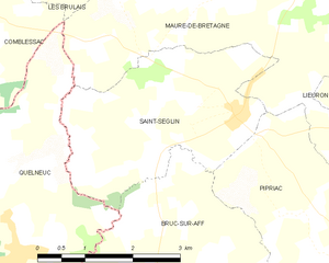
Bruc-sur-Aff (Bruc-sur-Aff)

- commune in Ille-et-Vilaine, France
- Country:

- Postal Code: 35550
- Coordinates: 47° 48' 53" N, 2° 1' 7" E


- GPS tracks (wikiloc): [Link]
- Area: 21.23 sq km
- Population: 859
- Web site: http://www.bruc-sur-aff.fr
- Wikipedia en: wiki(en)
- Wikipedia: wiki(fr)
- Wikidata storage: Wikidata: Q1011068
- Wikipedia Commons Category: [Link]
- Freebase ID: [/m/03c8nsy]
- Freebase ID: [/m/03c8nsy]
- Freebase ID: [/m/03c8nsy]
- GeoNames ID: Alt: [3029812]
- GeoNames ID: Alt: [3029812]
- GeoNames ID: Alt: [3029812]
- SIREN number: [213500457]
- SIREN number: [213500457]
- SIREN number: [213500457]
- BnF ID: [15256989r]
- BnF ID: [15256989r]
- BnF ID: [15256989r]
- OSM relation ID: [107915]
- OSM relation ID: [107915]
- OSM relation ID: [107915]
- PACTOLS thesaurus ID: [pcrtlKZQeSU8pT]
- PACTOLS thesaurus ID: [pcrtlKZQeSU8pT]
- PACTOLS thesaurus ID: [pcrtlKZQeSU8pT]
- INSEE municipality code: 35045
- INSEE municipality code: 35045
- INSEE municipality code: 35045
Shares border with regions:

Saint-Séglin
- commune in Ille-et-Vilaine, France
- Country:
- Postal Code: 35330
- Coordinates: 47° 51' 12" N, 2° 0' 17" E
- GPS tracks (wikiloc): [Link]
- Area: 9.4 sq km
- Population: 546

Sixt-sur-Aff
- commune in Ille-et-Vilaine, France
- Country:
- Postal Code: 35550
- Coordinates: 47° 46' 33" N, 2° 4' 42" E
- GPS tracks (wikiloc): [Link]
- Area: 42.5 sq km
- Population: 2097
- Web site: [Link]


Quelneuc
- former commune in Morbihan, France
- Country:
- Postal Code: 56910
- Coordinates: 47° 49' 24" N, 2° 4' 0" E
- GPS tracks (wikiloc): [Link]
- Area: 13.85 sq km
- Population: 546
- Web site: [Link]


Saint-Just
- commune in Ille-et-Vilaine, France
- Country:
- Postal Code: 35550
- Coordinates: 47° 45' 57" N, 1° 57' 40" E
- GPS tracks (wikiloc): [Link]
- Area: 28.05 sq km
- Population: 1081
- Web site: [Link]


Pipriac
- commune in Ille-et-Vilaine, France
- Country:
- Postal Code: 35550
- Coordinates: 47° 48' 33" N, 1° 56' 52" E
- GPS tracks (wikiloc): [Link]
- Area: 48.65 sq km
- Population: 3699