Saint-Just (Saint-Just)

- commune in Ille-et-Vilaine, France
- Country:

- Postal Code: 35550
- Coordinates: 47° 45' 57" N, 1° 57' 40" E


- GPS tracks (wikiloc): [Link]
- Area: 28.05 sq km
- Population: 1081
- Web site: http://www.saintjust35.fr
- Wikipedia en: wiki(en)
- Wikipedia: wiki(fr)
- Wikidata storage: Wikidata: Q195853
- Wikipedia Commons Category: [Link]
- Freebase ID: [/m/03mf18h]
- Freebase ID: [/m/03mf18h]
- Freebase ID: [/m/03mf18h]
- GeoNames ID: Alt: [6432843]
- GeoNames ID: Alt: [6432843]
- GeoNames ID: Alt: [6432843]
- SIREN number: [213502859]
- SIREN number: [213502859]
- SIREN number: [213502859]
- BnF ID: [15257227h]
- BnF ID: [15257227h]
- BnF ID: [15257227h]
- OSM relation ID: [145993]
- OSM relation ID: [145993]
- OSM relation ID: [145993]
- Library of Congress authority ID: Alt: [n94024388]
- Library of Congress authority ID: Alt: [n94024388]
- Library of Congress authority ID: Alt: [n94024388]
- PACTOLS thesaurus ID: [pcrtYXfQhlonLi]
- PACTOLS thesaurus ID: [pcrtYXfQhlonLi]
- PACTOLS thesaurus ID: [pcrtYXfQhlonLi]
- INSEE municipality code: 35285
- INSEE municipality code: 35285
- INSEE municipality code: 35285
Shares border with regions:


Bruc-sur-Aff
- commune in Ille-et-Vilaine, France
- Country:
- Postal Code: 35550
- Coordinates: 47° 48' 53" N, 2° 1' 7" E
- GPS tracks (wikiloc): [Link]
- Area: 21.23 sq km
- Population: 859
- Web site: [Link]

Sixt-sur-Aff
- commune in Ille-et-Vilaine, France
- Country:
- Postal Code: 35550
- Coordinates: 47° 46' 33" N, 2° 4' 42" E
- GPS tracks (wikiloc): [Link]
- Area: 42.5 sq km
- Population: 2097
- Web site: [Link]


Renac
- commune in Ille-et-Vilaine, France
- Country:
- Postal Code: 35660
- Coordinates: 47° 43' 11" N, 1° 58' 35" E
- GPS tracks (wikiloc): [Link]
- Area: 25.89 sq km
- Population: 977


Langon
- commune in Ille-et-Vilaine, France
- Country:
- Postal Code: 35660
- Coordinates: 47° 43' 11" N, 1° 50' 53" E
- GPS tracks (wikiloc): [Link]
- Area: 36.54 sq km
- Population: 1463
- Web site: [Link]


Pipriac
- commune in Ille-et-Vilaine, France
- Country:
- Postal Code: 35550
- Coordinates: 47° 48' 33" N, 1° 56' 52" E
- GPS tracks (wikiloc): [Link]
- Area: 48.65 sq km
- Population: 3699
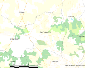
Saint-Ganton
- commune in Ille-et-Vilaine, France
- Country:
- Postal Code: 35550
- Coordinates: 47° 45' 14" N, 1° 52' 58" E
- GPS tracks (wikiloc): [Link]
- Area: 14.08 sq km
- Population: 418