Buccheri (Buccheri)
.svg)
- Italian comune
 Hiking in Buccheri
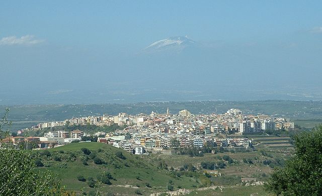
Buccheri, a charming village in Sicily, offers a unique hiking experience for both novice and experienced hikers. Nestled in the Hyblaean Mountains, this area is known for its stunning natural landscapes, rich historical sites, and diverse flora and fauna.
Hiking Trails
-
Monte Lauro: This is one of the most popular hikes in the Buccheri area. The trail takes you up to the summit of Monte Lauro, where you can enjoy breathtaking panoramic views of the surrounding countryside and even the Ionian Sea on clear days. The hike can be challenging, especially as you approach the summit, but the vistas are well worth the effort.
-
Cava d’Ispica: This natural canyon is a fascinating area for hiking, offering both historical and geological interest. The trail runs through ancient caves and archaeological sites, and you can encounter stunning rock formations and rich plant life. The hike here is moderately easy, making it accessible for families and less experienced hikers.
-
Sendero di Buccheri: This trail is ideal for those looking to discover the local flora and fauna. The loop trail showcases the rural landscape around Buccheri, passing by olive trees, vineyards, and traditional Sicilian farms. This is a great option for a leisurely walk while taking in the sights of the village.
Difficulty Levels
- Beginner Trails: Many of the routes around Buccheri have beginner-friendly options with gentle terrain and marked paths, making them suitable for families and casual hikers.
- Intermediate to Advanced Trails: For more experienced hikers, the trails leading to Monte Lauro and the more rugged sections of Cava d’Ispica offer a more challenging experience.
Best Times to Hike
- Spring and Fall: These seasons are ideal for hiking, as temperatures are mild, and the vegetation is lush. Springtime often brings wildflowers that enhance the beauty of the landscape.
- Summer: While possible, hiking during the summer can be quite hot, so it’s important to start early in the morning or later in the evening to avoid the heat.
Tips for Hiking in Buccheri
- Hydration: Always carry enough water, especially in warmer months.
- Footwear: Proper hiking boots are recommended for rocky or uneven terrain.
- Local Wildlife: Keep an eye out for local wildlife, and respect their habitats.
- Local Guides: Consider hiring a local guide for a deeper understanding of the area’s geography and history.
Conclusion
Buccheri offers a beautiful and rewarding hiking experience, blending natural beauty with a dose of Sicilian culture. Whether you’re looking for a leisurely stroll or a challenging trek, the trails around this picturesque village will provide a memorable outdoor adventure.
- Country:

- Postal Code: 96010
- Local Dialing Code: 0931
- Licence Plate Code: SR
- Coordinates: 37° 7' 30" N, 14° 51' 7" E


- GPS tracks (wikiloc): [Link]
- AboveSeaLevel: 820 м m
- Area: 57.83 sq km
- Population: 1951
- Web site: http://www.comunedibuccheri.it/
- Wikipedia en: wiki(en)
- Wikipedia: wiki(it)
- Wikidata storage: Wikidata: Q489958
- Wikipedia Commons Gallery: [Link]
- Wikipedia Commons Category: [Link]
- Freebase ID: [/m/0f8k38]
- GeoNames ID: Alt: [6537817]
- VIAF ID: Alt: [127028486]
- OSM relation ID: [39193]
- GND ID: Alt: [4774261-6]
- ISTAT ID: 089003
- Italian cadastre code: B237
Shares border with regions:

Carlentini
- Italian comune
Hiking in Carlentini
Carlentini is a charming town located in Sicily, Italy, known for its beautiful landscapes and rich cultural heritage. While it may not be the first destination that comes to mind for hiking, there are some wonderful opportunities for outdoor enthusiasts in and around the area. Here are some key points to consider when planning a hiking trip to Carlentini:...
- Country:
- Postal Code: 96013
- Local Dialing Code: 095
- Licence Plate Code: SR
- Coordinates: 37° 17' 0" N, 15° 1' 0" E
- GPS tracks (wikiloc): [Link]
- AboveSeaLevel: 190 м m
- Area: 158.91 sq km
- Population: 17741
- Web site: [Link]


Giarratana
- Italian comune
Hiking in Giarratana
Giarratana, a picturesque town located in the province of Ragusa in Sicily, Italy, offers some delightful hiking opportunities that cater to both novice and experienced hikers. The surrounding landscape is characterized by rolling hills, lush forests, and stunning views of the Val di Noto....
- Country:
- Postal Code: 97010
- Local Dialing Code: 0932
- Licence Plate Code: RG
- Coordinates: 37° 3' 0" N, 14° 48' 0" E
- GPS tracks (wikiloc): [Link]
- AboveSeaLevel: 520 м m
- Area: 43.63 sq km
- Population: 2962
- Web site: [Link]

Vizzini
- Italian comune
Hiking in Vizzini
Vizzini is a charming town located in the province of Catania, Sicily, Italy. It is perched on a hilltop and offers stunning views of the surrounding landscape, including vineyards and olive groves. While Vizzini itself is not widely known as a hiking destination, its location provides access to some beautiful hiking opportunities in the nearby areas. Here are some highlights for hiking around Vizzini:...
- Country:
- Postal Code: 95049
- Local Dialing Code: 0933
- Licence Plate Code: CT
- Coordinates: 37° 10' 0" N, 14° 45' 0" E
- GPS tracks (wikiloc): [Link]
- AboveSeaLevel: 586 м m
- Area: 126.75 sq km
- Population: 6072
- Web site: [Link]


Buscemi
- Italian comune
Hiking in Buscemi
Buscemi is a charming town located in the southeastern part of Sicily, Italy, known for its rich history, beautiful landscapes, and proximity to many hiking opportunities. Here’s what you should know about hiking in and around Buscemi:...
- Country:
- Postal Code: 96010
- Local Dialing Code: 0931
- Licence Plate Code: SR
- Coordinates: 37° 5' 0" N, 14° 52' 0" E
- GPS tracks (wikiloc): [Link]
- AboveSeaLevel: 761 м m
- Area: 52.05 sq km
- Population: 1022
- Web site: [Link]


Francofonte
- Italian comune
Hiking in Francofonte
Francofonte, located in the province of Syracuse in Sicily, Italy, offers several hiking opportunities surrounded by beautiful natural landscapes, rich history, and unique flora and fauna. Here are some highlights of hiking in the area:...
- Country:
- Postal Code: 96015
- Local Dialing Code: 095
- Licence Plate Code: SR
- Coordinates: 37° 14' 0" N, 14° 53' 0" E
- GPS tracks (wikiloc): [Link]
- AboveSeaLevel: 281 м m
- Area: 74.2 sq km
- Population: 12661
- Web site: [Link]


Ferla
- Italian comune
Hiking in Ferla
Ferla is a charming village located in the Province of Syracuse in Sicily, Italy. Surrounded by natural beauty and rich history, it offers a variety of hiking opportunities that cater to different skill levels. Here are some aspects to consider if you're planning a hike in or around Ferla:...
- Country:
- Postal Code: 96010
- Local Dialing Code: 0931
- Licence Plate Code: SR
- Coordinates: 37° 7' 0" N, 14° 57' 0" E
- GPS tracks (wikiloc): [Link]
- AboveSeaLevel: 556 м m
- Area: 24.9 sq km
- Population: 2447
- Web site: [Link]