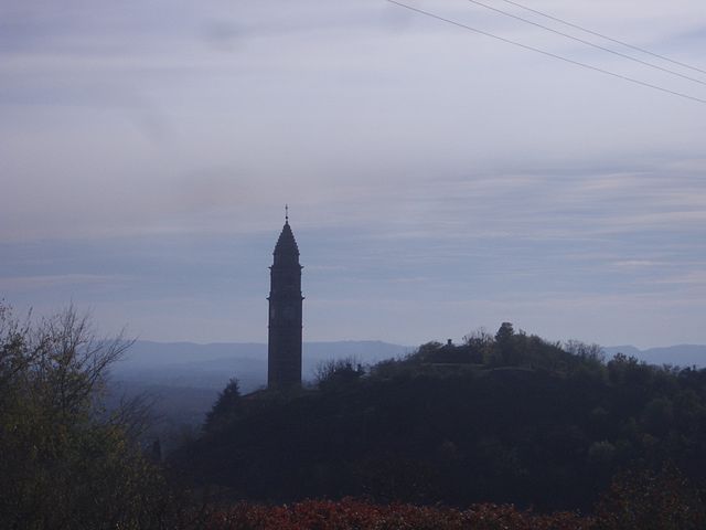
Burolo (Burolo)

- Italian comune
 Hiking in Burolo
Burolo is a picturesque town located in the Piedmont region of Italy, surrounded by beautiful landscapes that make it an attractive destination for hiking enthusiasts. The area is characterized by its rolling hills, vineyards, and stunning views of the surrounding mountains, including the Alps.
Hiking Trails:
-
Sentiero dell’Anima: This scenic trail takes you through lush forests and offers breathtaking views of the surrounding valleys. It is well-marked and suitable for hikers of various skill levels.
-
Colle del Lys: A popular destination for hikers, this area provides trails that lead to panoramic viewpoints. You can enjoy hiking through meadows and forests while observing local flora and fauna.
-
Cascina Bertagna: This trail offers a mix of easy walks and more challenging routes, leading to traditional rural landscapes and showcasing the region's agricultural heritage.
-
Barbaresco Trail: While a bit further from Burolo, this trail explores the famous Barbaresco vineyards, making it ideal for wine lovers who want to combine their hiking experience with local wine culture.
Tips for Hiking in Burolo:
- Map and Navigation: Always carry a map or use a GPS app to stay oriented, as some trails can be less well-marked.
- Proper Gear: Wear sturdy hiking boots and weather-appropriate clothing. Depending on the season, be prepared for variable weather conditions.
- Hydration and Snacks: Carry sufficient water and snacks, especially for longer hikes, to stay energized.
- Respect Nature: Follow the "Leave No Trace" principles to preserve the natural beauty of the area.
Best Seasons for Hiking:
- Spring (March to June): Ideal for wildflower blooms and pleasantly mild weather.
- Fall (September to November): Enjoy stunning autumn foliage and harvest season in the vineyards.
Before you go, it's always a good idea to check local resources for trail conditions and potential restrictions. Enjoy your hiking adventure in Burolo!
- Country:

- Postal Code: 10010
- Local Dialing Code: 0125
- Licence Plate Code: TO
- Coordinates: 45° 29' 0" N, 7° 56' 0" E


- GPS tracks (wikiloc): [Link]
- AboveSeaLevel: 300 м m
- Area: 5.48 sq km
- Population: 1160
- Web site: http://www.comune.burolo.to.it/
- Wikipedia en: wiki(en)
- Wikipedia: wiki(it)
- Wikidata storage: Wikidata: Q9108
- Wikipedia Commons Category: [Link]
- Freebase ID: [/m/0g6t93]
- GeoNames ID: Alt: [6537261]
- OSM relation ID: [45098]
- TGN ID: [7057693]
- UN/LOCODE: [ITBRO]
- ISTAT ID: 001042
- Italian cadastre code: B279
Shares border with regions:
Torrazzo
- Italian comune
Hiking in Torrazzo
Torrazzo, located in Italy, is best known for its historic bell tower in the city of Cremona rather than for hiking specifically. However, if you're asking about the general hiking opportunities in the surrounding Lombardy region, there are many beautiful trails and natural areas worth exploring....
- Country:
- Postal Code: 13884
- Local Dialing Code: 015
- Licence Plate Code: BI
- Coordinates: 45° 29' 55" N, 7° 57' 15" E
- GPS tracks (wikiloc): [Link]
- AboveSeaLevel: 622 м m
- Area: 5.77 sq km
- Population: 212
- Web site: [Link]


Bollengo
- Italian comune
Hiking in Bollengo
Bollengo is a small town located in the Piedmont region of Italy, surrounded by beautiful landscapes that are perfect for hiking enthusiasts. The area offers a variety of trails suited for different experience levels, from gentle walks to more challenging hikes....
- Country:
- Postal Code: 10012
- Local Dialing Code: 0125
- Licence Plate Code: TO
- Coordinates: 45° 28' 0" N, 7° 57' 0" E
- GPS tracks (wikiloc): [Link]
- AboveSeaLevel: 234 м m
- Area: 14.22 sq km
- Population: 2144
- Web site: [Link]


Cascinette d'Ivrea
- Italian comune
Hiking in Cascinette d'Ivrea
Cascinette d'Ivrea, located in the Piedmont region of northern Italy, is situated near the foothills of the Alps and offers beautiful landscapes and a variety of hiking opportunities. While it may not be as well-known as some larger hiking destinations, it provides a unique experience for outdoor enthusiasts....
- Country:
- Postal Code: 10010
- Local Dialing Code: 0125
- Licence Plate Code: TO
- Coordinates: 45° 29' 0" N, 7° 54' 0" E
- GPS tracks (wikiloc): [Link]
- AboveSeaLevel: 239 м m
- Area: 2.17 sq km
- Population: 1531
- Web site: [Link]

Chiaverano
- Italian comune
Hiking in Chiaverano
Chiaverano is a charming town located in the Canavese region of northern Italy, close to the foothills of the Alps. This area offers a blend of natural beauty, cultural heritage, and a variety of hiking opportunities for enthusiasts of all levels....
- Country:
- Postal Code: 10010
- Local Dialing Code: 0125
- Licence Plate Code: TO
- Coordinates: 45° 30' 0" N, 7° 54' 0" E
- GPS tracks (wikiloc): [Link]
- AboveSeaLevel: 329 м m
- Area: 12.02 sq km
- Population: 2073
- Web site: [Link]

Ivrea
- Italian comune
Hiking in Ivrea
Ivrea, a charming town located in the Piedmont region of northern Italy, offers a variety of hiking opportunities set against a backdrop of beautiful landscapes, mountains, and historical sites. Here are some highlights and tips for hiking in and around Ivrea:...
- Country:
- Postal Code: 10015
- Local Dialing Code: 0125
- Licence Plate Code: TO
- Coordinates: 45° 27' 44" N, 7° 52' 29" E
- GPS tracks (wikiloc): [Link]
- AboveSeaLevel: 253 м m
- Area: 30.11 sq km
- Population: 23637
- Web site: [Link]