Buxerolles (Buxerolles)

- commune in Côte-d'Or, France
- Country:

- Postal Code: 21290
- Coordinates: 47° 48' 26" N, 4° 55' 56" E


- GPS tracks (wikiloc): [Link]
- Area: 11.97 sq km
- Population: 28
- Wikipedia en: wiki(en)
- Wikipedia: wiki(fr)
- Wikidata storage: Wikidata: Q1019830
- Wikipedia Commons Category: [Link]
- Freebase ID: [/m/03mfn39]
- GeoNames ID: Alt: [6428520]
- SIREN number: [212101232]
- BnF ID: [15250410n]
- VIAF ID: Alt: [134329996]
- INSEE municipality code: 21123
Shares border with regions:

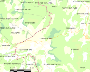
Colmier-le-Haut
- commune in Haute-Marne, France
- Country:
- Postal Code: 52160
- Coordinates: 47° 46' 51" N, 4° 57' 57" E
- GPS tracks (wikiloc): [Link]
- Area: 19.35 sq km
- Population: 52


Arbot
- commune in Haute-Marne, France
- Country:
- Postal Code: 52160
- Coordinates: 47° 51' 1" N, 5° 0' 34" E
- GPS tracks (wikiloc): [Link]
- Area: 13.15 sq km
- Population: 73


Rouvres-sur-Aube
- commune in Haute-Marne, France
- Country:
- Postal Code: 52160
- Coordinates: 47° 51' 28" N, 4° 59' 41" E
- GPS tracks (wikiloc): [Link]
- Area: 20.18 sq km
- Population: 106


Chambain
- commune in Côte-d'Or, France
- Country:
- Postal Code: 21290
- Coordinates: 47° 47' 53" N, 4° 55' 15" E
- GPS tracks (wikiloc): [Link]
- Area: 9.75 sq km
- Population: 39


Gurgy-le-Château
- commune in Côte-d'Or, France
- Country:
- Postal Code: 21290
- Coordinates: 47° 49' 36" N, 4° 55' 36" E
- GPS tracks (wikiloc): [Link]
- AboveSeaLevel: 370 м m
- Area: 17.65 sq km
- Population: 41