Buxières-d'Aillac (Buxières-d'Aillac)

- commune in Indre, France
- Country:

- Postal Code: 36230
- Coordinates: 46° 38' 18" N, 1° 45' 9" E


- GPS tracks (wikiloc): [Link]
- Area: 25.75 sq km
- Population: 259
- Web site: http://mairiebuxieresdail.wixsite.com/buxieres-d-aillac
- Wikipedia en: wiki(en)
- Wikipedia: wiki(fr)
- Wikidata storage: Wikidata: Q1071832
- Wikipedia Commons Category: [Link]
- Freebase ID: [/m/03nvb16]
- GeoNames ID: Alt: [3029358]
- SIREN number: [213600307]
- BnF ID: [152573342]
- INSEE municipality code: 36030
Shares border with regions:

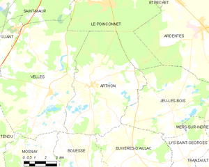
Arthon
- commune in Indre, France
- Country:
- Postal Code: 36330
- Coordinates: 46° 41' 37" N, 1° 41' 58" E
- GPS tracks (wikiloc): [Link]
- Area: 46.8 sq km
- Population: 1241


Gournay
- commune in Indre, France
- Country:
- Postal Code: 36230
- Coordinates: 46° 34' 59" N, 1° 43' 52" E
- GPS tracks (wikiloc): [Link]
- Area: 20.33 sq km
- Population: 307
- Web site: [Link]


Neuvy-Saint-Sépulchre
- commune in Indre, France
- Country:
- Postal Code: 36230
- Coordinates: 46° 35' 46" N, 1° 48' 31" E
- GPS tracks (wikiloc): [Link]
- AboveSeaLevel: 191 м m
- Area: 35.11 sq km
- Population: 1660

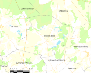
Jeu-les-Bois
- commune in Indre, France
- Country:
- Postal Code: 36120
- Coordinates: 46° 40' 24" N, 1° 47' 42" E
- GPS tracks (wikiloc): [Link]
- Area: 38.32 sq km
- Population: 389

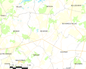
Bouesse
- commune in Indre, France
- Country:
- Postal Code: 36200
- Coordinates: 46° 36' 59" N, 1° 41' 16" E
- GPS tracks (wikiloc): [Link]
- Area: 24.19 sq km
- Population: 422

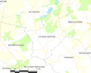
Lys-Saint-Georges
- commune in Indre, France
- Country:
- Postal Code: 36230
- Coordinates: 46° 38' 31" N, 1° 49' 24" E
- GPS tracks (wikiloc): [Link]
- Area: 12.98 sq km
- Population: 239
- Web site: [Link]