
Cagliari (Cagliari)


- Italian comune
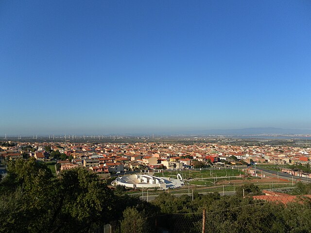
 Hiking in Cagliari
Cagliari, the capital of Sardinia, offers a variety of hiking opportunities that cater to different levels of experience and interest. The region is known for its stunning coastal scenery, mountainous terrain, and rich natural landscapes. Here are some key highlights for hiking in and around Cagliari:
1.
Located about 30 kilometers from Cagliari, this protected area features rugged mountains, forests, and diverse wildlife. There are numerous trails for hiking, some leading to panoramic views of the surrounding landscape. The park is home to various endemic species and is ideal for nature lovers.
2.
This coastal park is famous for its pink flamingos and offers a mix of walking and cycling trails. The easy paths make it a great choice for families or more leisurely hikes. You can enjoy birdwatching while taking in views of the salt flats and the nearby coastline.
3.
You can hike along the coastal cliffs of Capo Sant'Elia for breathtaking views of the Gulf of Cagliari. There are several trails in this area, ranging from easy walks to more challenging hikes. The view from Monte Sant'Elia, the highest point in the area, is particularly rewarding.
4.
Several trails lead to picturesque beaches such as Cala Fighera. The trails often offer unique geological formations and rich Mediterranean flora. It’s a great way to combine hiking with time at the beach.
5.
For those interested in history, the Tuvixeddu Necropolis is the largest Punic necropolis in the world. There are paths that allow you to explore this archaeological site along with enjoying great views of the city.
6.
This iconic peak is located just outside of Cagliari and features several hiking trails. The paths provide sweeping views of the city and the surrounding sea, making it a popular destination for both locals and tourists.
Hiking Tips for Cagliari:
- Footwear: Wear good hiking shoes, as trails can be rocky or uneven.
- Water and Snacks: Always carry enough water and some snacks, especially for longer hikes.
- Weather: The summer can get quite hot, so early morning or late afternoon hikes are preferable.
- Wildlife: Keep an eye out for wildlife, especially in protected areas.
- Respect Nature: Stay on marked trails to protect the environment and follow guidelines to preserve the natural beauty.
Whether you're looking for a casual stroll or a more challenging trek, Cagliari offers a variety of hiking experiences to explore its rich landscapes and history.
- Country:

- Postal Code: 09134; 09121–09131
- Local Dialing Code: 070
- Licence Plate Code: CA
- Coordinates: 39° 13' 0" N, 9° 7' 0" E


- GPS tracks (wikiloc): [Link]
- AboveSeaLevel: 4 м m
- Area: 85.45 sq km
- Population: 154411
- Web site: http://www.comune.cagliari.it/
- Wikipedia en: wiki(en)
- Wikipedia: wiki(it)
- Wikidata storage: Wikidata: Q1897
- Wikipedia Commons Gallery: [Link]
- Wikipedia Commons Category: [Link]
- Wikipedia Commons Maps Category: [Link]
- Freebase ID: [/m/0c7l_]
- GeoNames ID: Alt: [6540125]
- VIAF ID: Alt: [134322728]
- OSM relation ID: [39837]
- GND ID: Alt: [4085112-6]
- archINFORM location ID: [1049]
- MusicBrainz area ID: [6e11785f-3b28-4c15-b7f5-9d63006d93ef]
- Quora topic ID: [Cagliari-Italy-1]
- UN/LOCODE: [ITCAG]
- Encyclopædia Britannica Online ID: [place/Cagliari-Italy]
- Gran Enciclopèdia Catalana ID: [0013611]
- Encyclopædia Universalis ID: [cagliari]
- Facebook Places ID: [114120705270558]
- Great Russian Encyclopedia Online ID: [2037622]
- Digital Atlas of the Roman Empire ID: [16177]
- National Library of Israel ID: [000027447]
- ISTAT ID: 092009
- Italian cadastre code: B354
- US National Archives Identifier: 10046430
Shares border with regions:


Selargius
- Italian comune
Hiking in Selargius
Selargius is a charming town in Sardinia, Italy, located just a few kilometers from the capital city of Cagliari. While it might not be as renowned for hiking as some other regions of Sardinia, the surrounding areas offer plenty of opportunities for outdoor enthusiasts. Here are some aspects to consider for hiking around Selargius:...
- Country:
- Postal Code: 09047
- Local Dialing Code: 070
- Licence Plate Code: CA
- Coordinates: 39° 15' 13" N, 9° 9' 38" E
- GPS tracks (wikiloc): [Link]
- AboveSeaLevel: 10 м m
- Area: 26.67 sq km
- Population: 28986
- Web site: [Link]


Assemini
- Italian comune
Hiking in Assemini
Assemini is a town located in the southern part of Sardinia, Italy, not far from the capital city of Cagliari. While Assemini itself may not be renowned for extensive hiking trails, it serves as a great starting point for exploring the stunning landscapes and natural environments of the surrounding area....
- Country:
- Postal Code: 09032
- Local Dialing Code: 070
- Licence Plate Code: CA
- Coordinates: 39° 17' 23" N, 9° 0' 17" E
- GPS tracks (wikiloc): [Link]
- AboveSeaLevel: 6 м m
- Area: 118.17 sq km
- Population: 26901
- Web site: [Link]

Capoterra
- Italian comune
Hiking in Capoterra
Capoterra, located in the region of Sardinia, Italy, offers beautiful landscapes and several hiking opportunities that highlight the island's natural beauty. Here are some key points about hiking in that area:...
- Country:
- Postal Code: 09012
- Local Dialing Code: 070
- Licence Plate Code: CA
- Coordinates: 39° 10' 31" N, 8° 58' 15" E
- GPS tracks (wikiloc): [Link]
- AboveSeaLevel: 54 м m
- Area: 68.49 sq km
- Population: 23583
- Web site: [Link]


Elmas
- Italian comune
Hiking in Elmas
Elmas, a small town in Sardinia, Italy, is not widely known as a hiking destination, but it offers beautiful landscapes and access to nearby natural areas that are ideal for outdoor activities. Here are some key points to consider when hiking in and around Elmas:...
- Country:
- Postal Code: 09067
- Local Dialing Code: 070
- Licence Plate Code: CA
- Coordinates: 39° 16' 4" N, 9° 3' 0" E
- GPS tracks (wikiloc): [Link]
- AboveSeaLevel: 7 м m
- Area: 13.63 sq km
- Population: 9546
- Web site: [Link]


Monserrato
- Italian comune
Hiking in Monserrato
Monserrato is a beautiful area located near Cagliari in Sardinia, Italy. It is known for its stunning landscapes, rich history, and a variety of hiking trails suitable for different experience levels. Here are some key points to consider if you're planning a hike in Monserrato:...
- Country:
- Postal Code: 09042
- Local Dialing Code: 070
- Licence Plate Code: CA
- Coordinates: 39° 15' 25" N, 9° 8' 19" E
- GPS tracks (wikiloc): [Link]
- AboveSeaLevel: 2 м m
- Area: 6.43 sq km
- Population: 19771
- Web site: [Link]


Quartucciu
- Italian comune
Hiking in Quartucciu
Quartucciu, located in the region of Sardinia, Italy, offers beautiful landscapes and a variety of hiking opportunities. Here are some details about hiking in and around Quartucciu:...
- Country:
- Postal Code: 09044
- Local Dialing Code: 070
- Licence Plate Code: CA
- Coordinates: 39° 15' 10" N, 9° 10' 34" E
- GPS tracks (wikiloc): [Link]
- AboveSeaLevel: 14 м m
- Area: 27.93 sq km
- Population: 13234
- Web site: [Link]


Quartu Sant'Elena
- Italian comune
Hiking in Quartu Sant'Elena
Quartu Sant'Elena, located on the southeastern coast of Sardinia, Italy, offers a variety of hiking opportunities that showcase the region's natural beauty, including stunning coastlines, rugged hills, and lush countryside. Here are some key points to consider if you're planning to hike in and around Quartu Sant'Elena:...
- Country:
- Postal Code: 09046; 09045
- Local Dialing Code: 070
- Licence Plate Code: CA
- Coordinates: 39° 13' 45" N, 9° 15' 54" E
- GPS tracks (wikiloc): [Link]
- AboveSeaLevel: 6 м m
- Area: 96.41 sq km
- Population: 70879
- Web site: [Link]


Sestu
- Italian comune
Hiking in Sestu
Sestu, a municipality located in the Metropolitan City of Cagliari in Sardinia, Italy, is not typically known for extensive hiking trails like some other regions in Sardinia. However, the surrounding areas do offer some opportunities for outdoor activities and hiking....
- Country:
- Postal Code: 09028
- Local Dialing Code: 070
- Licence Plate Code: CA
- Coordinates: 39° 17' 58" N, 9° 5' 31" E
- GPS tracks (wikiloc): [Link]
- AboveSeaLevel: 44 м m
- Area: 48.29 sq km
- Population: 20958
- Web site: [Link]