
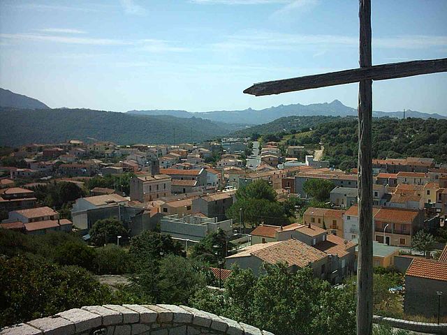
Calangianus (Calangianus)
%20-%202016.svg)
- Italian comune
 Hiking in Calangianus
Calangianus, located in the Gallura region of Sardinia, Italy, is a fantastic area for hiking enthusiasts. The region is characterized by its rugged terrain, rich natural beauty, and diverse ecosystems, offering various hiking trails that cater to different skill levels.
Key Highlights of Hiking in Calangianus:
-
Scenic Views: The trails around Calangianus often have stunning panoramic views of the surrounding mountains, valleys, and the coastline. The varied landscapes include granite formations, lush forests, and Mediterranean scrub.
-
Trail Options:
- Moderate to Challenging Trails: Many trails can be moderately challenging, featuring uneven terrain and elevation changes that require a good level of fitness.
- Family-Friendly Paths: There are also easier, well-marked paths suitable for families and beginners, allowing visitors to enjoy the natural scenery without strenuous effort.
-
Flora and Fauna: The region is home to diverse plant and animal life. Hikers may encounter various native species, including wildflowers, aromatic herbs, and perhaps even some wildlife such as deer, foxes, and various birds.
-
Cultural Sites: While hiking, you may come across archaeological sites or traditional Sardinian structures, enriching your experience with the local culture and history.
-
Best Time to Hike: The ideal time for hiking in Calangianus is during the spring (April to June) and autumn (September to October) when the weather is mild and more conducive to outdoor activities.
-
Local Tips:
- Carry sufficient water and snacks, as some trails may be remote.
- Wear appropriate hiking footwear for rocky and uneven paths.
- Check local maps or hire a guide if you’re unfamiliar with the area.
-
Access and Amenities: Calangianus is relatively accessible by car, and you can find local amenities such as small shops and restaurants in the nearby towns.
Remember to respect the natural environment, follow local regulations, and enjoy the breathtaking beauty that Calangianus has to offer on your hiking adventure!
- Country:

- Postal Code: 07023
- Local Dialing Code: 079
- Licence Plate Code: SS
- Coordinates: 40° 55' 20" N, 9° 11' 41" E


- GPS tracks (wikiloc): [Link]
- AboveSeaLevel: 518 м m
- Area: 126.35 sq km
- Population: 4082
- Web site: http://www.calangianus.it/
- Wikipedia en: wiki(en)
- Wikipedia: wiki(it)
- Wikidata storage: Wikidata: Q340721
- Wikipedia Commons Category: [Link]
- Freebase ID: [/m/0gr9m9]
- GeoNames ID: Alt: [6541974]
- OSM relation ID: [40827]
- WOEID: [711694]
- UN/LOCODE: [ITOLL]
- Treccani ID: [calangianus]
- ISTAT ID: 090021
- Italian cadastre code: B378
Shares border with regions:


Tempio Pausania
- Italian comune
Hiking in Tempio Pausania
Tempio Pausania, located in the northern part of Sardinia, Italy, is surrounded by picturesque landscapes, making it an excellent destination for hiking enthusiasts. The area is characterized by its unique granite formations, lush forests, and a variety of trails suitable for different hiking levels....
- Country:
- Postal Code: 07029
- Local Dialing Code: 079
- Licence Plate Code: SS
- Coordinates: 40° 54' 5" N, 9° 6' 16" E
- GPS tracks (wikiloc): [Link]
- AboveSeaLevel: 566 м m
- Area: 210.82 sq km
- Population: 13973
- Web site: [Link]


Berchidda
- Italian comune
Hiking in Berchidda
Berchidda is a beautiful village located in the province of Olbia-Tempio in Sardinia, Italy. Nestled in the northeastern part of the island, Berchidda is surrounded by stunning landscapes that make it a great destination for hiking enthusiasts. Here are some highlights of hiking in and around Berchidda:...
- Country:
- Postal Code: 07022
- Local Dialing Code: 079
- Licence Plate Code: SS
- Coordinates: 40° 47' 9" N, 9° 9' 57" E
- GPS tracks (wikiloc): [Link]
- AboveSeaLevel: 290 м m
- Area: 201.88 sq km
- Population: 2749
- Web site: [Link]


Luras
- Italian comune
Hiking in Luras
Luras, located in the beautiful region of Sardinia, Italy, is an excellent destination for hiking enthusiasts. The area is characterized by stunning landscapes, rich culture, and a variety of trails suitable for different skill levels....
- Country:
- Postal Code: 07025
- Local Dialing Code: 079
- Licence Plate Code: SS
- Coordinates: 40° 56' 9" N, 9° 10' 29" E
- GPS tracks (wikiloc): [Link]
- AboveSeaLevel: 500 м m
- Area: 87.59 sq km
- Population: 2528
- Web site: [Link]


Monti, Sardinia
- Italian comune
Hiking in Monti, Sardinia
Hiking in Monti, Sardinia, offers a truly unique experience due to the area's stunning landscapes, rich biodiversity, and charming small towns. Monti is located in the Gallura region, known for its granite rock formations, rolling hills, and beautiful Mediterranean flora and fauna....
- Country:
- Postal Code: 07020
- Local Dialing Code: 0789
- Licence Plate Code: SS
- Coordinates: 40° 48' 25" N, 9° 19' 36" E
- GPS tracks (wikiloc): [Link]
- AboveSeaLevel: 300 м m
- Area: 123.82 sq km
- Population: 2413
- Web site: [Link]

Sant'Antonio di Gallura
- Italian comune
Hiking in Sant'Antonio di Gallura
Sant'Antonio di Gallura, located in the northern part of Sardinia, Italy, is a beautiful destination for hiking enthusiasts. The region is characterized by its stunning landscapes, rich flora and fauna, and a rugged coastline. Here are some highlights and tips for hiking in this area:...
- Country:
- Postal Code: 07030
- Local Dialing Code: 079
- Licence Plate Code: SS
- Coordinates: 40° 59' 31" N, 9° 18' 6" E
- GPS tracks (wikiloc): [Link]
- AboveSeaLevel: 354 м m
- Area: 81.69 sq km
- Population: 1502
- Web site: [Link]


Telti
- Italian comune
Hiking in Telti
Telti is a charming village located in the Sardinia region of Italy, near the larger town of Olbia. It’s surrounded by beautiful landscapes that offer various hiking opportunities, making it an excellent area for outdoor enthusiasts....
- Country:
- Postal Code: 07020
- Local Dialing Code: 0789
- Licence Plate Code: SS
- Coordinates: 40° 53' 0" N, 9° 21' 0" E
- GPS tracks (wikiloc): [Link]
- AboveSeaLevel: 326 м m
- Area: 83.25 sq km
- Population: 2297
- Web site: [Link]