Calciano (Calciano)
.svg)
- Italian comune
 Hiking in Calciano
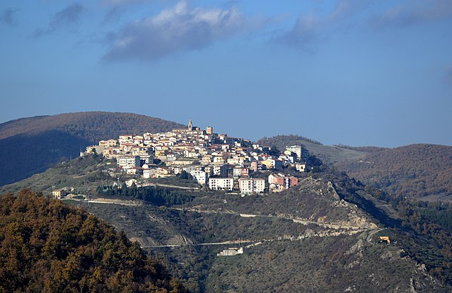
Calciano is a small village in the southern Italian region of Basilicata, nestled in the hills near the larger town of Potenza. While not as well-known as some other hiking destinations in Italy, Calciano and its surrounding areas offer picturesque landscapes and a peaceful environment for outdoor activities.
Hiking Opportunities:
-
Natural Scenery: The area is characterized by rolling hills, valleys, and diverse flora, making it a great destination for nature lovers. The trails can vary from easy walks to more strenuous hikes, suitable for different skill levels.
-
Local Trails: There may be less-marked local trails that connect Calciano to nearby villages or natural sites. Exploring these paths can lead you to beautiful vistas and unique geological features.
-
Nearby Parks: The nearby Pollino National Park is a must-visit if you're seeking more extensive hiking opportunities. It features higher altitudes and stunning landscapes, such as rugged mountains and deep gorges.
-
Cultural Sites: Hikes in and around Calciano can also include visits to historic sites, local churches, and traditional architecture, providing insight into the culture of the region.
Tips for Hiking in Calciano:
- Weather Check: Be sure to check the weather ahead of your hike, as conditions can change quickly in hilly areas.
- Local Guidance: If you’re unfamiliar with the area, consider seeking advice or hiring a local guide who knows the best routes and hidden gems.
- Hydration and Snacks: Bring plenty of water and snacks, especially if you plan on hiking for several hours.
- Appropriate Gear: Wear comfortable hiking shoes and clothing suited for varying terrain and weather conditions.
Safety Precautions:
- Always inform someone about your hiking plans.
- Carry a map or download navigation apps on your phone in case of poor signal.
- Respect the natural environment and follow Leave No Trace principles.
If you’re looking for a tranquil hiking experience steeped in nature and culture, Calciano and its surroundings can offer a delightful escape.
- Country:

- Postal Code: 75010
- Local Dialing Code: 0835
- Licence Plate Code: MT
- Coordinates: 40° 35' 0" N, 16° 12' 0" E


- GPS tracks (wikiloc): [Link]
- AboveSeaLevel: 420 м m
- Area: 49.69 sq km
- Population: 739
- Web site: http://www.comune.calciano.mt.it/
- Wikipedia en: wiki(en)
- Wikipedia: wiki(it)
- Wikidata storage: Wikidata: Q52280
- Wikipedia Commons Category: [Link]
- Freebase ID: [/m/0fgtz9]
- Freebase ID: [/m/0fgtz9]
- GeoNames ID: Alt: [6539020]
- GeoNames ID: Alt: [6539020]
- VIAF ID: Alt: [125691749]
- VIAF ID: Alt: [125691749]
- OSM relation ID: [40596]
- OSM relation ID: [40596]
- Digital Atlas of the Roman Empire ID: [29207]
- Digital Atlas of the Roman Empire ID: [29207]
- ISTAT ID: 077004
- ISTAT ID: 077004
- Italian cadastre code: B391
- Italian cadastre code: B391
Shares border with regions:


Accettura
- Italian comune
Hiking in Accettura
Accettura, a charming town located in the Basilicata region of southern Italy, is known for its beautiful landscapes and rich natural resources, which make it an excellent destination for hiking enthusiasts....
- Country:
- Postal Code: 75011
- Local Dialing Code: 0835
- Licence Plate Code: MT
- Coordinates: 40° 29' 0" N, 16° 9' 0" E
- GPS tracks (wikiloc): [Link]
- AboveSeaLevel: 770 м m
- Area: 90.37 sq km
- Population: 1807
- Web site: [Link]
Garaguso
- Italian comune
Hiking in Garaguso
Garaguso, a small village located in the province of Matera in Southern Italy, is characterized by its beautiful landscapes, charming countryside, and rich cultural heritage. While Garaguso may not be as famous for hiking as some other locations in Italy, it offers opportunities for nature walks and outdoor activities....
- Country:
- Postal Code: 75010
- Local Dialing Code: 0835
- Licence Plate Code: MT
- Coordinates: 40° 33' 0" N, 16° 14' 0" E
- GPS tracks (wikiloc): [Link]
- AboveSeaLevel: 460 м m
- Area: 38.61 sq km
- Population: 1038
- Web site: [Link]
Grassano
- Italian comune
Hiking in Grassano
Grassano is a charming town located in the Basilicata region of Italy, known for its beautiful landscapes and rich history. While it may not be as famous as some other hiking destinations, the area around Grassano offers opportunities for hiking enthusiasts to explore the countryside, enjoy stunning views, and discover local flora and fauna....
- Country:
- Postal Code: 75014
- Local Dialing Code: 0835
- Licence Plate Code: MT
- Coordinates: 40° 38' 0" N, 16° 17' 0" E
- GPS tracks (wikiloc): [Link]
- AboveSeaLevel: 576 м m
- Area: 41.63 sq km
- Population: 5077
- Web site: [Link]
Oliveto Lucano
- Italian comune
Hiking in Oliveto Lucano
Oliveto Lucano is a charming town located in the Basilicata region of Southern Italy. It offers a unique opportunity for hikers and nature enthusiasts to explore the surrounding landscapes, which are characterized by rolling hills, dense forests, and stunning vistas. Here are some highlights and tips for hiking in Oliveto Lucano:...
- Country:
- Postal Code: 75010
- Local Dialing Code: 0835
- Licence Plate Code: MT
- Coordinates: 40° 32' 0" N, 16° 11' 0" E
- GPS tracks (wikiloc): [Link]
- AboveSeaLevel: 546 м m
- Area: 31.19 sq km
- Population: 417
- Web site: [Link]


Tricarico
- Italian comune
Hiking in Tricarico
Tricarico, a charming village in the Basilicata region of southern Italy, offers a unique hiking experience enriched by its stunning landscapes, rich history, and cultural heritage. Here are some highlights and tips for hiking in and around Tricarico:...
- Country:
- Postal Code: 75019
- Local Dialing Code: 0835
- Licence Plate Code: MT
- Coordinates: 40° 37' 0" N, 16° 9' 0" E
- GPS tracks (wikiloc): [Link]
- AboveSeaLevel: 698 м m
- Area: 178.16 sq km
- Population: 5202
- Web site: [Link]

Albano di Lucania
- Italian comune
Hiking in Albano di Lucania
Albano di Lucania is a picturesque village located in the Basilicata region of southern Italy, surrounded by the stunning landscapes of the Apennine Mountains. The area offers a variety of hiking opportunities that cater to different skill levels, allowing hikers to explore its natural beauty, historical sites, and local culture....
- Country:
- Postal Code: 85010
- Local Dialing Code: 0971
- Licence Plate Code: PZ
- Coordinates: 40° 35' 0" N, 16° 2' 0" E
- GPS tracks (wikiloc): [Link]
- AboveSeaLevel: 899 м m
- Area: 55.87 sq km
- Population: 1409
- Web site: [Link]


Campomaggiore
- Italian comune
Hiking in Campomaggiore
Campomaggiore is a small town located in the Basilicata region of southern Italy. It is known for its rich history, stunning landscapes, and hiking opportunities that appeal to both beginner and experienced hikers. Here are some details about hiking in the area:...
- Country:
- Postal Code: 85010
- Local Dialing Code: 0971
- Licence Plate Code: PZ
- Coordinates: 40° 33' 57" N, 16° 4' 21" E
- GPS tracks (wikiloc): [Link]
- AboveSeaLevel: 810 м m
- Area: 12.48 sq km
- Population: 786
- Web site: [Link]