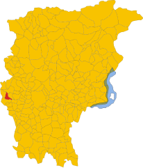
Calusco d'Adda (Calusco d'Adda)
.svg)
- Italian comune
 Hiking in Calusco d'Adda
Calusco d'Adda, located in the Lombardy region of Italy, offers a charming setting for hiking enthusiasts. The area is characterized by picturesque landscapes, rolling hills, and the meandering Adda River. Here are some key points to consider when hiking in and around Calusco d'Adda:
Trail Options
-
Natural Parks and Reserves: The nearby Adda Nord Park is a fantastic spot for hiking. It features numerous trails that allow you to explore the area's natural beauty, including the river’s scenic banks and lush woodlands.
-
Scenic Routes: Many trails around Calusco d'Adda provide stunning views of the river and surrounding countryside. Look for paths that lead to elevated viewpoints for the best panoramic sights.
-
Historical Trails: Some hikes may take you past historical sites or through small villages, allowing hikers to experience the local culture along with the natural scenery.
Difficulty Levels
Trails in the Calusco d'Adda area can vary in difficulty. There are options for beginners looking for an easy stroll as well as more challenging hikes for seasoned trekkers. It’s always a good idea to check trail markers and maps provided by local tourist information spots.
Best Time to Hike
- Spring and Fall: These seasons offer mild weather and beautiful scenery, with wildflowers blooming in spring and autumn leaves creating a vibrant tapestry of colors.
- Summer: Be prepared for warm temperatures, and opt for early morning or late afternoon hikes to avoid the heat.
Safety Considerations
- Stay Hydrated: Carry enough water, especially during warmer months.
- Trail Etiquette: Always follow marked trails, respect wildlife, and be cautious of your surroundings.
- Check Weather Conditions: Rain can make trails slippery, so it’s wise to check forecasts before heading out.
Local Amenities
Calusco d'Adda has several spots where you can eat or rest after a hike. Look for local trattorias to enjoy authentic Italian cuisine.
Overall, Calusco d'Adda can be a delightful destination for those looking to combine outdoor activities with beautiful scenery and local culture. Be sure to explore the area and find the trails that suit your preferences!
- Country:

- Postal Code: 24033
- Local Dialing Code: 035
- Licence Plate Code: BG
- Coordinates: 45° 41' 0" N, 9° 29' 0" E


- GPS tracks (wikiloc): [Link]
- AboveSeaLevel: 273 м m
- Area: 8.33 sq km
- Population: 8378
- Web site: http://www.comune.calusco.bg.it
- Wikipedia en: wiki(en)
- Wikipedia: wiki(it)
- Wikidata storage: Wikidata: Q100128
- Wikipedia Commons Gallery: [Link]
- Wikipedia Commons Category: [Link]
- Freebase ID: [/m/0gj916]
- GeoNames ID: Alt: [6540172]
- VIAF ID: Alt: [247861660]
- OSM relation ID: [45715]
- TGN ID: [7045318]
- UN/LOCODE: [ITCLD]
- ISTAT ID: 016046
- Italian cadastre code: B434
Shares border with regions:

Carvico
- Italian comune
Hiking in Carvico
Carvico, located in the Lombardy region of Italy, is a charming destination for hikers and nature enthusiasts. Situated near the stunning Orobie Alps and not far from the picturesque Lake Como, Carvico offers a variety of trails that cater to different skill levels, from leisurely walks to more challenging hikes....
- Country:
- Postal Code: 24030
- Local Dialing Code: 035
- Licence Plate Code: BG
- Coordinates: 45° 42' 0" N, 9° 29' 0" E
- GPS tracks (wikiloc): [Link]
- AboveSeaLevel: 287 м m
- Area: 4.59 sq km
- Population: 4659
- Web site: [Link]


Medolago
- Italian comune
Hiking in Medolago
Medolago is a small town located in the Lombardy region of Italy, close to the city of Bergamo. While it may not be as widely known for hiking as some of the more mountainous areas in Italy, there are still opportunities for nature walks and hiking in the surrounding areas....
- Country:
- Postal Code: 24030
- Local Dialing Code: 035
- Licence Plate Code: BG
- Coordinates: 45° 40' 0" N, 9° 30' 0" E
- GPS tracks (wikiloc): [Link]
- AboveSeaLevel: 246 м m
- Area: 3.8 sq km
- Population: 2398
- Web site: [Link]


Solza
- Italian comune
Hiking in Solza
As of my last update, Solza is a small town in Italy, situated near the beautiful landscape of the Bergamo region in Lombardy. While it may not be a renowned hiking destination in itself, it is in proximity to several areas that offer fantastic hiking opportunities....
- Country:
- Postal Code: 24030
- Local Dialing Code: 035
- Licence Plate Code: BG
- Coordinates: 45° 40' 43" N, 9° 29' 27" E
- GPS tracks (wikiloc): [Link]
- AboveSeaLevel: 254 м m
- Area: 1.23 sq km
- Population: 2075
- Web site: [Link]


Terno d'Isola
- Italian comune
Hiking in Terno d'Isola
Terno d'Isola is a charming town located in the province of Bergamo, Lombardy, Italy. While it’s not typically recognized as a primary hiking destination, the surrounding region offers some lovely trails and opportunities for outdoor activities. Here are some insights about hiking in and around Terno d'Isola:...
- Country:
- Postal Code: 24030
- Local Dialing Code: 035
- Licence Plate Code: BG
- Coordinates: 45° 41' 0" N, 9° 32' 0" E
- GPS tracks (wikiloc): [Link]
- AboveSeaLevel: 299 м m
- Area: 4.13 sq km
- Population: 8106
- Web site: [Link]


Villa d'Adda
- Italian comune
Hiking in Villa d'Adda
Villa d'Adda is a charming location in Italy, situated on the banks of the Adda River in the Lombardy region. This area is well-suited for hiking enthusiasts, offering scenic trails, beautiful landscapes, and opportunities to experience local culture....
- Country:
- Postal Code: 24030
- Local Dialing Code: 035
- Licence Plate Code: BG
- Coordinates: 45° 43' 0" N, 9° 28' 0" E
- GPS tracks (wikiloc): [Link]
- AboveSeaLevel: 286 м m
- Area: 5.98 sq km
- Population: 4681
- Web site: [Link]


Robbiate
- Italian comune
Hiking in Robbiate
Robbiate, located in the Lombardy region of Italy, offers various outdoor activities and scenic landscapes for hiking enthusiasts. The area is characterized by its picturesque views, rolling hills, and access to nearby natural parks and trails. Here are some key aspects of hiking in Robbiate:...
- Country:
- Postal Code: 23899
- Local Dialing Code: 039
- Licence Plate Code: LC
- Coordinates: 45° 41' 0" N, 9° 26' 0" E
- GPS tracks (wikiloc): [Link]
- AboveSeaLevel: 265 м m
- Area: 4.7 sq km
- Population: 6337
- Web site: [Link]


Paderno d'Adda
- Italian comune
Hiking in Paderno d'Adda
Paderno d'Adda, located in the Lombardy region of Italy, is a beautiful area for hiking, set along the Adda River. The landscape is characterized by rolling hills, lush forests, and scenic views of the river and surrounding countryside, making it a delightful destination for outdoor enthusiasts....
- Country:
- Postal Code: 23877
- Local Dialing Code: 039
- Licence Plate Code: LC
- Coordinates: 45° 41' 0" N, 9° 27' 0" E
- GPS tracks (wikiloc): [Link]
- AboveSeaLevel: 266 м m
- Area: 3.56 sq km
- Population: 3855
- Web site: [Link]