
Camogli (Camogli)
.svg)
- Italian comune
 Hiking in Camogli
Camogli, a picturesque fishing village located on the Italian Riviera in Liguria, offers some stunning hiking opportunities with breathtaking views of the coastline and the Mediterranean Sea. Here are some key points about hiking in and around Camogli:
Trails and Routes
-
Trail to San Rocco: A popular hike that leads you from Camogli to the nearby hilltop village of San Rocco. The trail is well-marked, providing panoramic views of the Gulf of Paradise and the Ligurian coastline.
-
Via dei Monti Liguri: This historic long-distance trail runs through Camogli, offering segments that you can explore. It takes you through the scenic hills and includes beautiful stretches of forest and traditional Ligurian stone villages.
-
Parco Naturale Regionale di Portofino: Close to Camogli, this natural park has numerous trails ranging from easy to challenging. The trails offer stunning vistas, diverse flora and fauna, and opportunities to see wildlife. One popular route is the hike to the lighthouse at Punta Chiappa.
-
Camogli to Portofino: A more intense hike that connects Camogli to Portofino, this trail takes you along the coast and through beautiful natural landscapes. It's a full-day hike and provides some of the most spectacular coastal views.
Hiking Tips
- Season: The best time for hiking is during the spring and fall when temperatures are mild, and the trails are less crowded.
- Gear: Wear sturdy hiking shoes, bring plenty of water, and pack snacks. A map or a hiking app is also recommended for navigation.
- Local Regulations: Always respect local wildlife and ecosystems. Stay on marked trails and follow guidelines set by the regional park authorities.
Other Activities
In addition to hiking, Camogli is known for its charming harbor, beautiful churches, and delicious seafood. After a day of hiking, you can enjoy fresh local cuisine at waterfront restaurants.
Conclusion
Hiking in Camogli offers a perfect blend of natural beauty, cultural experience, and outdoor adventure. Whether you're a seasoned hiker or a casual walker, there's something to enjoy for everyone in this beautiful part of the Italian Riviera.
- Country:

- Postal Code: 16032
- Local Dialing Code: 0185
- Licence Plate Code: GE
- Coordinates: 44° 20' 54" N, 9° 9' 21" E


- GPS tracks (wikiloc): [Link]
- AboveSeaLevel: 9 м m
- Area: 10.07 sq km
- Population: 5300
- Web site: http://www.comune.camogli.ge.it
- Wikipedia en: wiki(en)
- Wikipedia: wiki(it)
- Wikidata storage: Wikidata: Q266604
- Wikipedia Commons Category: [Link]
- Freebase ID: [/m/0dwvxk]
- GeoNames ID: Alt: [6537058]
- VIAF ID: Alt: [167725915]
- OSM relation ID: [43035]
- MusicBrainz area ID: [932f8e78-da28-49cf-8bf5-05c77697ac76]
- Quora topic ID: [Camogli]
- UN/LOCODE: [ITGLJ]
- Digital Atlas of the Roman Empire ID: [17184]
- ISTAT ID: 010007
- Italian cadastre code: B490
Shares border with regions:
Rapallo
- Italian comune
Hiking in Rapallo
Hiking in Rapallo, a charming coastal town in the Italian region of Liguria, offers a variety of scenic trails that showcase the natural beauty of the Italian Riviera. Here are some key points to consider:...
- Country:
- Postal Code: 16035
- Local Dialing Code: 0185
- Licence Plate Code: GE
- Coordinates: 44° 21' 0" N, 9° 14' 0" E
- GPS tracks (wikiloc): [Link]
- AboveSeaLevel: 3 м m
- Area: 33.61 sq km
- Population: 29728
- Web site: [Link]
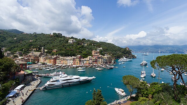

Portofino
- Italian comune
Hiking in Portofino
Hiking in Portofino, a picturesque village on the Italian Riviera in Liguria, is a fantastic way to explore its stunning natural beauty and enjoy breathtaking coastal views. Here are some key points to consider:...
- Country:
- Postal Code: 16034
- Local Dialing Code: 0185
- Licence Plate Code: GE
- Coordinates: 44° 18' 15" N, 9° 12' 26" E
- GPS tracks (wikiloc): [Link]
- AboveSeaLevel: 4 м m
- Area: 2.53 sq km
- Population: 416
- Web site: [Link]


Recco
- Italian comune
Hiking in Recco
Recco is a picturesque town located on the Ligurian coast of Italy, known for its beautiful landscapes, excellent cuisine, and charming vibe. While it might not be as famous as nearby Cinque Terre or Portofino, it offers fantastic hiking opportunities with stunning views of the coastline, the Mediterranean Sea, and the surrounding hills....
- Country:
- Postal Code: 16036
- Local Dialing Code: 0185
- Licence Plate Code: GE
- Coordinates: 44° 21' 44" N, 9° 8' 37" E
- GPS tracks (wikiloc): [Link]
- AboveSeaLevel: 5 м m
- Area: 9.77 sq km
- Population: 9683
- Web site: [Link]


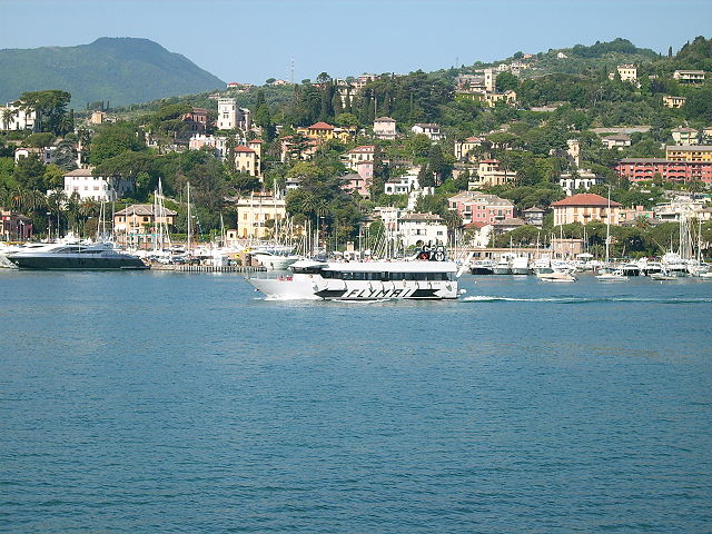
Santa Margherita Ligure
- Italian comune
Hiking in Santa Margherita Ligure
Santa Margherita Ligure, located along the stunning Italian Riviera in the Liguria region, offers picturesque hiking opportunities alongside beautiful coastal views, lush vegetation, and charming villages. Here are some highlights and tips regarding hiking in this area:...
- Country:
- Postal Code: 16038
- Local Dialing Code: 0185
- Licence Plate Code: GE
- Coordinates: 44° 20' 6" N, 9° 12' 36" E
- GPS tracks (wikiloc): [Link]
- AboveSeaLevel: 13 м m
- Area: 10.04 sq km
- Population: 9124
- Web site: [Link]