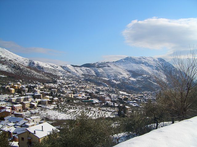
Campoli del Monte Taburno (Campoli del Monte Taburno)
.svg)
- Italian comune
 Hiking in Campoli del Monte Taburno
Campoli del Monte Taburno, located in the Campania region of Italy, offers a picturesque setting for hiking enthusiasts. Nestled within the Taburno-Campania Forest Regional Park, this area is known for its stunning landscapes, biodiversity, and a rich array of hiking trails that cater to various skill levels.
Trail Options
-
Sentiero del Monte Taburno: This is one of the most popular trails, leading you to the summit of Monte Taburno. The route offers breathtaking panoramic views of the surrounding valleys and hills. It's a moderately challenging hike, so a good level of fitness is recommended.
-
Piana del Lago: This trail offers an easier hike through lush countryside and is perfect for families or those looking for a more leisurely walk. It primarily follows flat terrain and lets you enjoy the serene beauty of the area.
-
Cascate di Caccavone: A shorter trail that leads to a picturesque waterfall. It's an excellent choice for a quick escape into nature, ideal for a half-day hike.
Flora and Fauna
The park surrounding Campoli del Monte Taburno is rich in biodiversity. Hikers can encounter various plant species, including chestnut and oak trees, as well as various wildflowers. The area is also home to wildlife, including deer, foxes, and many bird species, making for an enjoyable experience for nature lovers.
Tips for Hiking
- Best Time to Visit: Spring (April to June) and fall (September to October) are ideal for hiking, as temperatures are usually mild and the scenery is vibrant.
- What to Bring: Make sure to carry sufficient water, snacks, a first-aid kit, a map or GPS device, and wear sturdy hiking boots. Depending on the season, additional layers or rain gear may be necessary.
- Safety: Always inform someone of your hiking plans and expected return time. Mobile connectivity can be limited in some areas, so it's advisable to have a detailed map.
Getting There
Campoli del Monte Taburno is accessible by car, and public transport options are available from nearby towns. The area offers parking facilities for those arriving by car.
Overall, hiking in Campoli del Monte Taburno combines natural beauty, outdoor activity, and cultural experiences, making it a fantastic destination for both casual walkers and seasoned hikers.
- Country:

- Postal Code: 82030
- Local Dialing Code: 0824
- Licence Plate Code: BN
- Coordinates: 41° 8' 0" N, 14° 39' 0" E


- GPS tracks (wikiloc): [Link]
- AboveSeaLevel: 439 м m
- Area: 9.8 sq km
- Population: 1649
- Web site: http://www.comune.campolidelmontetaburno.bn.it/
- Wikipedia en: wiki(en)
- Wikipedia: wiki(it)
- Wikidata storage: Wikidata: Q55885
- Wikipedia Commons Category: [Link]
- Freebase ID: [/m/0gn163]
- GeoNames ID: Alt: [6537319]
- OSM relation ID: [41098]
- ISTAT ID: 062014
- Italian cadastre code: B542
Shares border with regions:
Apollosa
- Italian comune
Hiking in Apollosa
Apollosa, a charming town located in the province of Benevento in southern Italy, offers a variety of hiking opportunities for outdoor enthusiasts. The surrounding landscape features rolling hills, vineyards, and olive groves, providing a picturesque backdrop for your adventures....
- Country:
- Postal Code: 82030
- Local Dialing Code: 0824
- Licence Plate Code: BN
- Coordinates: 41° 6' 0" N, 14° 42' 0" E
- GPS tracks (wikiloc): [Link]
- AboveSeaLevel: 430 м m
- Area: 21.12 sq km
- Population: 2667
- Web site: [Link]


Castelpoto
- Italian comune
Hiking in Castelpoto
Castelpoto, a charming municipality located in the Campania region of Italy, offers a variety of hiking opportunities that allow you to explore the beautiful landscapes, historical sites, and local flora and fauna. Here are some aspects to consider when hiking in the area:...
- Country:
- Postal Code: 82030
- Local Dialing Code: 0824
- Licence Plate Code: BN
- Coordinates: 41° 9' 0" N, 14° 42' 0" E
- GPS tracks (wikiloc): [Link]
- AboveSeaLevel: 285 м m
- Area: 11.78 sq km
- Population: 1197
- Web site: [Link]
Cautano
- Italian comune
Hiking in Cautano
Cautano, located in the province of Benevento in the Campania region of Italy, is a beautiful area for hiking, offering stunning landscapes, rich history, and diverse flora and fauna. While it may not be as well-known as some other hiking destinations in Italy, Cautano provides a tranquil and scenic experience for those looking to explore the outdoors....
- Country:
- Postal Code: 82030
- Local Dialing Code: 0824
- Licence Plate Code: BN
- Coordinates: 41° 9' 0" N, 14° 38' 0" E
- GPS tracks (wikiloc): [Link]
- AboveSeaLevel: 300 м m
- Area: 19.72 sq km
- Population: 2017
- Web site: [Link]


Montesarchio
- Italian comune
Hiking in Montesarchio
Montesarchio, located in the Campania region of Italy, offers a variety of hiking opportunities amidst beautiful landscapes and historical sites. Here's what you can expect when hiking in this area:...
- Country:
- Postal Code: 82016
- Local Dialing Code: 0824
- Licence Plate Code: BN
- Coordinates: 41° 4' 0" N, 14° 38' 0" E
- GPS tracks (wikiloc): [Link]
- AboveSeaLevel: 300 м m
- Area: 26.51 sq km
- Population: 13508
- Web site: [Link]


Tocco Caudio
- Italian comune
Hiking in Tocco Caudio
Tocco Caudio, situated in the province of Benevento in the Campania region of Italy, is a captivating destination for hiking enthusiasts. The area is characterized by its scenic landscapes, rolling hills, and lush nature, making it an inviting spot for outdoor activities....
- Country:
- Postal Code: 82030
- Local Dialing Code: 0824
- Licence Plate Code: BN
- Coordinates: 41° 8' 0" N, 14° 38' 0" E
- GPS tracks (wikiloc): [Link]
- AboveSeaLevel: 540 м m
- Area: 27.49 sq km
- Population: 1551
- Web site: [Link]

Vitulano
- Italian comune
Hiking in Vitulano
Vitulano is a charming town located in the Campania region of Italy, known for its picturesque landscapes, historical sites, and opportunities for hiking and outdoor activities. Here are some aspects to consider if you’re planning to explore the hiking trails around Vitulano:...
- Country:
- Postal Code: 82038
- Local Dialing Code: 0824
- Licence Plate Code: BN
- Coordinates: 41° 11' 0" N, 14° 39' 0" E
- GPS tracks (wikiloc): [Link]
- AboveSeaLevel: 430 м m
- Area: 35.99 sq km
- Population: 2923
- Web site: [Link]