Canale (Canale)
- Italian comune
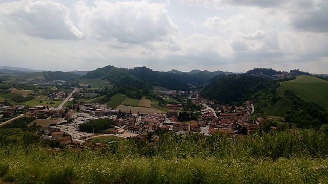
 Hiking in Canale
Canale, located in the Piedmont region of Italy, is a charming destination for hiking enthusiasts. Nestled in the heart of the Langhe wine region, Canale offers beautiful landscapes, rich culture, and a variety of trails suitable for all levels of hikers.
Hiking Opportunities
-
Trails: There are numerous hiking trails in and around Canale that range from easy walks through vineyards to more challenging paths that lead into the surrounding hills and forests. The trails often provide stunning views of the rolling hills, vineyards, and nearby mountains.
-
Nature and Scenery: The area is known for its picturesque landscapes, characterized by vineyards, old stone villages, and panoramic views. The famous rolling hills of the Langhe are UNESCO World Heritage sites and provide a beautiful backdrop for any hike.
-
Local Flora and Fauna: While hiking, you may encounter diverse flora and fauna, including grapevines, chestnut trees, and various bird species. Spring and summer hikes are particularly vibrant with wildflowers.
-
Wine and Gastronomy: Since Canale is in a prominent wine region, many hikes can be combined with vineyard visits. You can enjoy tasting local wines, such as Barbera and Nebbiolo, and sampling regional cuisine after your hikes.
-
Cultural Attractions: Beyond hiking, Canale and its surroundings are rich in history. You might want to explore local churches, historical buildings, and charming squares in the town.
Recommendations
-
Trail Maps: Consider obtaining a local hiking map or guide. Many trails are marked, but having a map will help you navigate more efficiently.
-
Fitness Level: Choose trails that match your fitness level; there are options for both beginners and experienced hikers.
-
Best Time to Visit: Spring and fall are ideal times for hiking in Piedmont, as the weather is pleasant, and the landscapes are particularly picturesque during these seasons.
-
Safety and Preparation: Always carry sufficient water, wear appropriate footwear, and be mindful of the weather. Cell service may be limited in remote areas, so plan accordingly.
If you're ever in Canale, take advantage of the hiking trails to immerse yourself in the natural beauty and cultural richness of the Piedmont region!
- Country:

- Postal Code: 12043
- Local Dialing Code: 0173
- Licence Plate Code: CN
- Coordinates: 44° 48' 0" N, 8° 0' 0" E


- GPS tracks (wikiloc): [Link]
- AboveSeaLevel: 193 м m
- Area: 17.87 sq km
- Population: 5624
- Web site: http://www.comune.canale.cn.it/
- Wikipedia en: wiki(en)
- Wikipedia: wiki(it)
- Wikidata storage: Wikidata: Q18394
- Wikipedia Commons Category: [Link]
- Freebase ID: [/m/0gb8c4]
- GeoNames ID: Alt: [6539907]
- BnF ID: [13193157k]
- VIAF ID: Alt: [241906997]
- OSM relation ID: [43615]
- Library of Congress authority ID: Alt: [nr88010142]
- MusicBrainz area ID: [0991d069-dee6-4100-a8b2-19ac5f517101]
- UN/LOCODE: [ITCDB]
- ISTAT ID: 004037
- Italian cadastre code: B573
Shares border with regions:


Cisterna d'Asti
- Italian comune
Hiking in Cisterna d'Asti
Cisterna d'Asti, located in the Piedmont region of Italy, offers a wonderful setting for hiking enthusiasts. Nestled in a scenic area characterized by rolling hills, vineyards, and charming countryside, it provides various trails suitable for different skill levels....
- Country:
- Postal Code: 14010
- Local Dialing Code: 0141
- Licence Plate Code: AT
- Coordinates: 44° 49' 38" N, 8° 0' 7" E
- GPS tracks (wikiloc): [Link]
- AboveSeaLevel: 350 м m
- Area: 10.73 sq km
- Population: 1204
- Web site: [Link]


San Damiano d'Asti
- Italian comune
Hiking in San Damiano d'Asti
San Damiano d'Asti, located in the Piedmont region of Italy, offers a charming landscape that is well-suited for hiking enthusiasts. The area is characterized by rolling hills, vineyards, and scenic countryside, making it an ideal spot for various hiking trails. Here are some highlights and tips for hiking in and around San Damiano d'Asti:...
- Country:
- Postal Code: 14015
- Local Dialing Code: 0141
- Licence Plate Code: AT
- Coordinates: 44° 50' 4" N, 8° 3' 53" E
- GPS tracks (wikiloc): [Link]
- AboveSeaLevel: 179 м m
- Area: 47.87 sq km
- Population: 8347
- Web site: [Link]

Castellinaldo
- Italian comune
Hiking in Castellinaldo
Castellinaldo d'Alba is a charming village located in the Piedmont region of northern Italy, well-known for its picturesque landscapes and vineyards. Hiking in this area offers a unique blend of natural beauty, cultural heritage, and culinary delights, particularly the famous wines of the Barolo region. Here are some insights into hiking in Castellinaldo d'Alba:...
- Country:
- Postal Code: 12050
- Local Dialing Code: 0173
- Licence Plate Code: CN
- Coordinates: 44° 47' 0" N, 8° 2' 0" E
- GPS tracks (wikiloc): [Link]
- AboveSeaLevel: 285 м m
- Area: 7.8 sq km
- Population: 930
- Web site: [Link]

Monteu Roero
- Italian comune
Hiking in Monteu Roero
Monteu Roero is a beautiful destination for hiking enthusiasts, located in the Roero region of Piedmont, Italy. This area is known for its stunning landscapes, characterized by rolling hills, vineyards, and charming villages. Here are some details to help you plan a hiking trip in Monteu Roero:...
- Country:
- Postal Code: 12040
- Local Dialing Code: 0173
- Licence Plate Code: CN
- Coordinates: 44° 47' 0" N, 7° 56' 0" E
- GPS tracks (wikiloc): [Link]
- AboveSeaLevel: 395 м m
- Area: 24.7 sq km
- Population: 1618
- Web site: [Link]

Montà
- Italian comune
Hiking in Montà
Montà, located in the Piedmont region of Italy, is known for its picturesque landscapes, rolling hills, and vineyards, making it a charming destination for hiking enthusiasts. Here are some highlights and tips for hiking in Montà:...
- Country:
- Postal Code: 12046
- Local Dialing Code: 0173
- Licence Plate Code: CN
- Coordinates: 44° 48' 53" N, 7° 57' 17" E
- GPS tracks (wikiloc): [Link]
- AboveSeaLevel: 316 м m
- Area: 26.82 sq km
- Population: 4712
- Web site: [Link]

Priocca
- Italian comune
Hiking in Priocca
Priocca is a small municipality located in the Piedmont region of Italy, surrounded by beautiful landscapes ideal for hiking and outdoor activities. The area features picturesque vineyards, rolling hills, and scenic views that are quintessential to the region....
- Country:
- Postal Code: 12040
- Local Dialing Code: 0173
- Licence Plate Code: CN
- Coordinates: 44° 47' 0" N, 8° 4' 0" E
- GPS tracks (wikiloc): [Link]
- AboveSeaLevel: 253 м m
- Area: 9.03 sq km
- Population: 2001
- Web site: [Link]
Santo Stefano Roero
- Italian comune
Hiking in Santo Stefano Roero
Santo Stefano Roero, located in the Piedmont region of Italy, is a beautiful area for hiking enthusiasts, especially those who appreciate scenic landscapes, vineyards, and historical sites. This region is characterized by its rolling hills, picturesque villages, and rich biodiversity, making it a wonderful destination for outdoor activities....
- Country:
- Postal Code: 12040
- Local Dialing Code: 0173
- Licence Plate Code: CN
- Coordinates: 44° 47' 0" N, 7° 57' 0" E
- GPS tracks (wikiloc): [Link]
- AboveSeaLevel: 330 м m
- Area: 13.11 sq km
- Population: 1387
- Web site: [Link]
Vezza d'Alba
- Italian comune
Hiking in Vezza d'Alba
Vezza d'Alba, located in the Piemonte region of northern Italy, offers a wonderful setting for hiking enthusiasts, thanks to its scenic landscapes, rolling hills, and proximity to the Langhe area, famous for its vineyards and gastronomy. Here are some highlights of hiking in and around Vezza d'Alba:...
- Country:
- Postal Code: 12040
- Local Dialing Code: 0173
- Licence Plate Code: CN
- Coordinates: 44° 46' 0" N, 8° 0' 0" E
- GPS tracks (wikiloc): [Link]
- AboveSeaLevel: 313 м m
- Area: 14.07 sq km
- Population: 2288
- Web site: [Link]