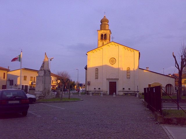
Candiana (Candiana)
.svg)
- Italian comune
 Hiking in Candiana
Hiking in Canada offers a diverse array of landscapes, trails, and experiences suited to all skill levels. Here are some highlights and popular hiking destinations across the country:
1.
- Trails: The Plain of Six Glaciers, Johnston Canyon, and the Larch Valley.
- Features: Stunning mountain scenery, glacial lakes, and abundant wildlife.
2.
- Trails: Maligne Canyon, Sulphur Skyline, and Edith Cavell Meadows.
- Features: Dramatic canyons, hot springs, and vast wilderness areas.
3.
- Trails: Skyline Trail and Cabot Trail.
- Features: Coastal cliffs, ocean views, and vibrant fall foliage.
4.
- Trails: Luskville Falls, Pink Lake, and several multi-use trails.
- Features: Close proximity to Ottawa, beautiful lakes, and panoramic views.
5.
- Trails: West Coast Trail and Rainforest Trail.
- Features: Rugged coastline, temperate rainforests, and diverse ecosystems.
6.
- Trails: Lookout Trail and the Mizzy Lake Trail.
- Features: Scenic lakes, diverse wildlife, and vast forest areas.
Tips for Hiking in Canada:
- Weather Preparedness: Conditions can change rapidly. Check the forecast and dress in layers.
- Wildlife Safety: Be aware of bears and other wildlife; carry bear spray and know what to do if you encounter them.
- Leave No Trace: Respect nature; pack out whatever you bring in and stick to marked trails.
- Stay Hydrated: Bring plenty of water and snacks, especially on longer hikes.
- Trail Conditions: Before heading out, check trail conditions for any closures or warnings.
Each province and territory has its unique features, so make sure to explore what each region has to offer. Happy hiking!
- Country:

- Postal Code: 35020
- Local Dialing Code: 049
- Licence Plate Code: PD
- Coordinates: 45° 13' 0" N, 11° 58' 0" E


- GPS tracks (wikiloc): [Link]
- AboveSeaLevel: 4 м m
- Area: 22.27 sq km
- Population: 2313
- Web site: http://www.comune.candiana.pd.it
- Wikipedia en: wiki(en)
- Wikipedia: wiki(it)
- Wikidata storage: Wikidata: Q34352
- Wikipedia Commons Category: [Link]
- Freebase ID: [/m/0gk43k]
- GeoNames ID: Alt: [6536668]
- VIAF ID: Alt: [238141014]
- OSM relation ID: [44446]
- GND ID: Alt: [4736523-7]
- UN/LOCODE: [ITCND]
- ISTAT ID: 028021
- Italian cadastre code: B589
Shares border with regions:
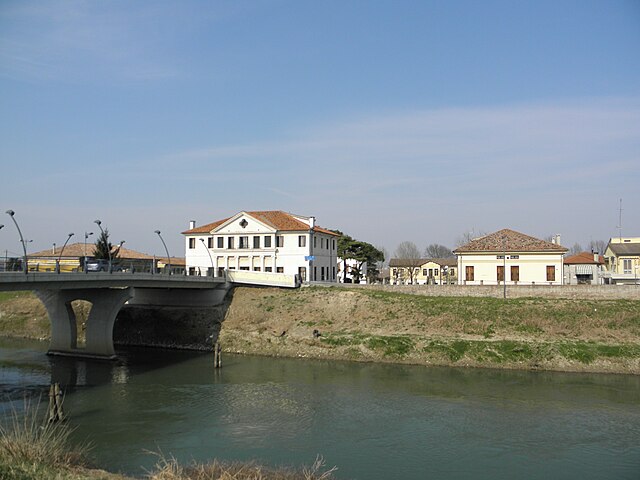
Correzzola
- Italian comune
Hiking in Correzzola
Correzzola, a small village in the Veneto region of Italy, is surrounded by beautiful natural landscapes that make it a lovely spot for hiking enthusiasts. Although Correzzola itself is not a major hiking destination, its proximity to various natural parks and regions offers several opportunities for outdoor activities....
- Country:
- Postal Code: 35020
- Local Dialing Code: 049
- Licence Plate Code: PD
- Coordinates: 45° 14' 0" N, 12° 4' 0" E
- GPS tracks (wikiloc): [Link]
- AboveSeaLevel: 2 м m
- Area: 42.33 sq km
- Population: 5194
- Web site: [Link]

Agna
- Italian comune
Hiking in Agna
Hiking in Agna, which is located in the municipality of Kainuu in Finland, offers a unique experience for outdoor enthusiasts. The region is known for its beautiful natural landscapes, including forests, lakes, and hills, which create a scenic backdrop for hiking....
- Country:
- Postal Code: 35021
- Local Dialing Code: 049
- Licence Plate Code: PD
- Coordinates: 45° 10' 0" N, 11° 58' 0" E
- GPS tracks (wikiloc): [Link]
- AboveSeaLevel: 5 м m
- Area: 18.8 sq km
- Population: 3277
- Web site: [Link]

Arre
- Italian comune
Hiking in Arre
Arre is a small town located in the province of Padua in the Veneto region of Italy. While it may not be as widely recognized as some of the more famous hiking destinations in Italy, it is situated near several areas that offer excellent opportunities for hiking and exploring the beautiful natural surroundings....
- Country:
- Postal Code: 35020
- Local Dialing Code: 049
- Licence Plate Code: PD
- Coordinates: 45° 13' 0" N, 11° 55' 0" E
- GPS tracks (wikiloc): [Link]
- AboveSeaLevel: 5 м m
- Area: 12.34 sq km
- Population: 2143
- Web site: [Link]
Pontelongo
- Italian comune
Hiking in Pontelongo
Pontelongo, a quaint town in the Veneto region of Italy, offers a unique blend of natural beauty and cultural heritage. Although it may not be as widely recognized as other hiking destinations in Italy, there are several charming trails and walking paths in and around the area that cater to outdoor enthusiasts....
- Country:
- Postal Code: 35029
- Local Dialing Code: 049
- Licence Plate Code: PD
- Coordinates: 45° 15' 0" N, 12° 1' 0" E
- GPS tracks (wikiloc): [Link]
- AboveSeaLevel: 5 м m
- Area: 10.89 sq km
- Population: 3741
- Web site: [Link]

Terrassa Padovana
- Italian comune
Hiking in Terrassa Padovana
Terrassa Padovana is located in the Veneto region of Italy, in an area that is rich in natural scenery and history. The region offers various hiking opportunities that cater to different skill levels....
- Country:
- Postal Code: 35020
- Local Dialing Code: 049
- Licence Plate Code: PD
- Coordinates: 45° 15' 0" N, 11° 54' 0" E
- GPS tracks (wikiloc): [Link]
- AboveSeaLevel: 6 м m
- Area: 14.81 sq km
- Population: 2637
- Web site: [Link]

Bovolenta
- Italian comune
Hiking in Bovolenta
Bovolenta is a small town in the Veneto region of Italy, known primarily for its agricultural landscape and proximity to the iconic scenery of the Veneto countryside. While Bovolenta itself may not be a hiking hotspot compared to larger natural reserves or mountainous areas, there are still opportunities for hiking and enjoying the outdoors....
- Country:
- Postal Code: 35024
- Local Dialing Code: 049
- Licence Plate Code: PD
- Coordinates: 45° 16' 0" N, 11° 56' 0" E
- GPS tracks (wikiloc): [Link]
- AboveSeaLevel: 6 м m
- Area: 22.78 sq km
- Population: 3471
- Web site: [Link]