Cannessières (Cannessières)

- commune in Somme, France
- Country:

- Postal Code: 80140
- Coordinates: 49° 56' 22" N, 1° 45' 50" E


- GPS tracks (wikiloc): [Link]
- Area: 3.75 sq km
- Population: 74
- Wikipedia en: wiki(en)
- Wikipedia: wiki(fr)
- Wikidata storage: Wikidata: Q735404
- Wikipedia Commons Category: [Link]
- Freebase ID: [/m/03mc_s2]
- GeoNames ID: Alt: [6444330]
- SIREN number: [218001626]
- BnF ID: [15276653b]
- INSEE municipality code: 80169
Shares border with regions:


Fontaine-le-Sec
- commune in Somme, France
- Country:
- Postal Code: 80140
- Coordinates: 49° 56' 38" N, 1° 48' 31" E
- GPS tracks (wikiloc): [Link]
- Area: 7.44 sq km
- Population: 155

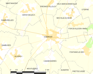
Oisemont
- commune in Somme, France
- Country:
- Postal Code: 80140
- Coordinates: 49° 57' 19" N, 1° 45' 59" E
- GPS tracks (wikiloc): [Link]
- Area: 8.04 sq km
- Population: 1175

Mouflières
- commune in Somme, France
- Country:
- Postal Code: 80140
- Coordinates: 49° 55' 19" N, 1° 44' 32" E
- GPS tracks (wikiloc): [Link]
- Area: 2.76 sq km
- Population: 90


Aumâtre
- commune in Somme, France
- Country:
- Postal Code: 80140
- Coordinates: 49° 55' 10" N, 1° 46' 20" E
- GPS tracks (wikiloc): [Link]
- Area: 5.57 sq km
- Population: 183