canton of Haroué (canton d'Haroué)
- canton of France
- Country:

- Capital: Haroué
- Coordinates: 48° 27' 25" N, 6° 12' 16" E


- GPS tracks (wikiloc): [Link]
- Wikidata storage: Wikidata: Q1725473
- Library of Congress authority ID: Alt: [nr95041846]
- INSEE canton code: [5414]
Includes regions:


Bainville-aux-Miroirs
- commune in Meurthe-et-Moselle, France
- Country:
- Postal Code: 54290
- Coordinates: 48° 26' 19" N, 6° 16' 36" E
- GPS tracks (wikiloc): [Link]
- Area: 6.76 sq km
- Population: 335
Vaudigny
- commune in Meurthe-et-Moselle, France
- Country:
- Postal Code: 54740
- Coordinates: 48° 26' 17" N, 6° 11' 56" E
- GPS tracks (wikiloc): [Link]
- Area: 3.94 sq km
- Population: 76


Roville-devant-Bayon
- commune in Meurthe-et-Moselle, France
- Country:
- Postal Code: 54290
- Coordinates: 48° 27' 58" N, 6° 17' 31" E
- GPS tracks (wikiloc): [Link]
- Area: 4.43 sq km
- Population: 794


Housséville
- commune in Meurthe-et-Moselle, France
- Country:
- Postal Code: 54930
- Coordinates: 48° 24' 22" N, 6° 7' 5" E
- GPS tracks (wikiloc): [Link]
- Area: 5.33 sq km
- Population: 169
Gerbécourt-et-Haplemont
- commune in Meurthe-et-Moselle, France
- Country:
- Postal Code: 54740
- Coordinates: 48° 29' 22" N, 6° 9' 47" E
- GPS tracks (wikiloc): [Link]
- Area: 5.26 sq km
- Population: 222

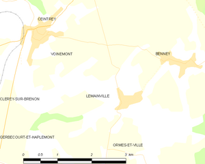
Lemainville
- commune in Meurthe-et-Moselle, France
- Country:
- Postal Code: 54740
- Coordinates: 48° 30' 14" N, 6° 11' 57" E
- GPS tracks (wikiloc): [Link]
- Area: 4.75 sq km
- Population: 373
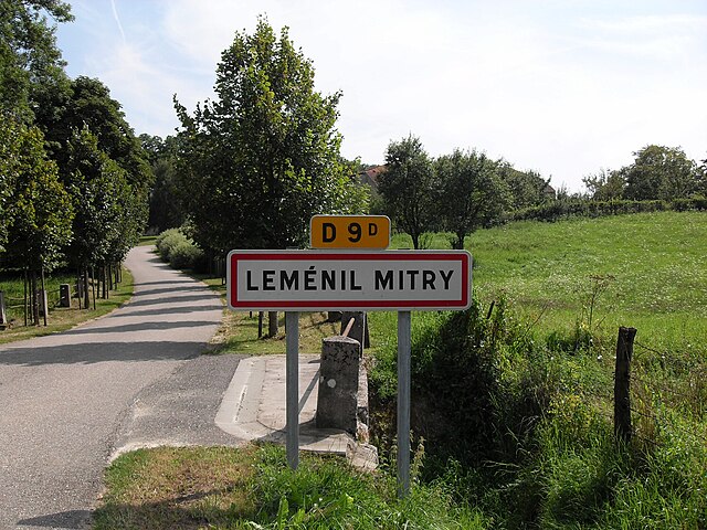

Leménil-Mitry
- commune in Meurthe-et-Moselle, France
- Country:
- Postal Code: 54740
- Coordinates: 48° 27' 8" N, 6° 15' 9" E
- GPS tracks (wikiloc): [Link]
- Area: 3.43 sq km
- Population: 3

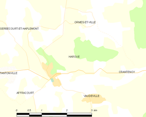
Haroué
- commune in Meurthe-et-Moselle, France
- Country:
- Postal Code: 54740
- Coordinates: 48° 28' 7" N, 6° 10' 40" E
- GPS tracks (wikiloc): [Link]
- Area: 4.14 sq km
- Population: 494


Ormes-et-Ville
- commune in Meurthe-et-Moselle, France
- Country:
- Postal Code: 54740
- Coordinates: 48° 29' 16" N, 6° 12' 11" E
- GPS tracks (wikiloc): [Link]
- Area: 12.49 sq km
- Population: 236

Laneuveville-devant-Bayon
- commune in Meurthe-et-Moselle, France
- Country:
- Postal Code: 54740
- Coordinates: 48° 28' 15" N, 6° 15' 57" E
- GPS tracks (wikiloc): [Link]
- Area: 5.75 sq km
- Population: 228


Vaudeville
- commune in Meurthe-et-Moselle, France
- Country:
- Postal Code: 54740
- Coordinates: 48° 27' 32" N, 6° 12' 4" E
- GPS tracks (wikiloc): [Link]
- Area: 9.05 sq km
- Population: 173


Lebeuville
- commune in Meurthe-et-Moselle, France
- Country:
- Postal Code: 54740
- Coordinates: 48° 26' 4" N, 6° 14' 44" E
- GPS tracks (wikiloc): [Link]
- Area: 6.22 sq km
- Population: 174


Mangonville
- commune in Meurthe-et-Moselle, France
- Country:
- Postal Code: 54290
- Coordinates: 48° 27' 22" N, 6° 17' 21" E
- GPS tracks (wikiloc): [Link]
- Area: 3.85 sq km
- Population: 231


Neuviller-sur-Moselle
- commune in Meurthe-et-Moselle, France
- Country:
- Postal Code: 54290
- Coordinates: 48° 29' 33" N, 6° 17' 14" E
- GPS tracks (wikiloc): [Link]
- AboveSeaLevel: 245 м m
- Area: 6.71 sq km
- Population: 214


Voinémont
- commune in Meurthe-et-Moselle, France
- Country:
- Postal Code: 54134
- Coordinates: 48° 31' 16" N, 6° 9' 47" E
- GPS tracks (wikiloc): [Link]
- Area: 4.11 sq km
- Population: 333
- Web site: [Link]


Benney
- commune in Meurthe-et-Moselle, France
- Country:
- Postal Code: 54740
- Coordinates: 48° 30' 47" N, 6° 13' 10" E
- GPS tracks (wikiloc): [Link]
- Area: 18.48 sq km
- Population: 639
- Web site: [Link]


Ceintrey
- commune in Meurthe-et-Moselle, France
- Country:
- Postal Code: 54134
- Coordinates: 48° 31' 30" N, 6° 9' 54" E
- GPS tracks (wikiloc): [Link]
- Area: 11 sq km
- Population: 915


Diarville
- commune in Meurthe-et-Moselle, France
- Country:
- Postal Code: 54930
- Coordinates: 48° 23' 43" N, 6° 7' 57" E
- GPS tracks (wikiloc): [Link]
- Area: 11.03 sq km
- Population: 524


Saint-Remimont
- commune in Meurthe-et-Moselle, France
- Country:
- Postal Code: 54740
- Coordinates: 48° 29' 53" N, 6° 14' 59" E
- GPS tracks (wikiloc): [Link]
- AboveSeaLevel: 346 м m
- Area: 6.79 sq km
- Population: 347


Bouzanville
- commune in Meurthe-et-Moselle, France
- Country:
- Postal Code: 54930
- Coordinates: 48° 22' 27" N, 6° 6' 7" E
- GPS tracks (wikiloc): [Link]
- Area: 5.82 sq km
- Population: 62


Bralleville
- commune in Meurthe-et-Moselle, France
- Country:
- Postal Code: 54740
- Coordinates: 48° 24' 17" N, 6° 11' 28" E
- GPS tracks (wikiloc): [Link]
- Area: 4.39 sq km
- Population: 177


Germonville
- commune in Meurthe-et-Moselle, France
- Country:
- Postal Code: 54740
- Coordinates: 48° 24' 25" N, 6° 12' 45" E
- GPS tracks (wikiloc): [Link]
- Area: 5.21 sq km
- Population: 121


Gripport
- commune in Meurthe-et-Moselle, France
- Country:
- Postal Code: 54290
- Coordinates: 48° 24' 53" N, 6° 15' 11" E
- GPS tracks (wikiloc): [Link]
- Area: 5.74 sq km
- Population: 285


Tantonville
- commune in Meurthe-et-Moselle, France
- Country:
- Postal Code: 54116
- Coordinates: 48° 28' 9" N, 6° 8' 20" E
- GPS tracks (wikiloc): [Link]
- Area: 8.09 sq km
- Population: 643


Xirocourt
- commune in Meurthe-et-Moselle, France
- Country:
- Postal Code: 54740
- Coordinates: 48° 25' 50" N, 6° 10' 21" E
- GPS tracks (wikiloc): [Link]
- Area: 11.32 sq km
- Population: 454
- Web site: [Link]


Crantenoy
- commune in Meurthe-et-Moselle, France
- Country:
- Postal Code: 54740
- Coordinates: 48° 28' 2" N, 6° 13' 37" E
- GPS tracks (wikiloc): [Link]
- Area: 5.28 sq km
- Population: 146


Crévéchamps
- commune in Meurthe-et-Moselle, France
- Country:
- Postal Code: 54290
- Coordinates: 48° 31' 25" N, 6° 15' 56" E
- GPS tracks (wikiloc): [Link]
- Area: 4.86 sq km
- Population: 381
- Web site: [Link]