canton of Cajarc (canton de Cajarc)
- canton of France
- Country:

- Capital: Cajarc
- Coordinates: 44° 30' 31" N, 1° 52' 4" E


- GPS tracks (wikiloc): [Link]
- Area: 190.4 sq km
- Wikidata storage: Wikidata: Q1724695
- INSEE canton code: [4604]
Includes regions:

Saint-Jean-de-Laur
- commune in Lot, France
- Country:
- Postal Code: 46260
- Coordinates: 44° 25' 11" N, 1° 50' 9" E
- GPS tracks (wikiloc): [Link]
- Area: 21.57 sq km
- Population: 227

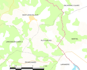
Puyjourdes
- commune in Lot, France
- Country:
- Postal Code: 46260
- Coordinates: 44° 24' 27" N, 1° 51' 38" E
- GPS tracks (wikiloc): [Link]
- Area: 7.83 sq km
- Population: 90
Carayac
- commune in Lot, France
- Country:
- Postal Code: 46160
- Coordinates: 44° 32' 51" N, 1° 55' 24" E
- GPS tracks (wikiloc): [Link]
- Area: 6.87 sq km
- Population: 93
Frontenac
- commune in Lot, France
- Country:
- Postal Code: 46160
- Coordinates: 44° 32' 22" N, 1° 58' 17" E
- GPS tracks (wikiloc): [Link]
- Area: 2.84 sq km
- Population: 66
Cadrieu
- commune in Lot, France
- Country:
- Postal Code: 46160
- Coordinates: 44° 29' 31" N, 1° 52' 47" E
- GPS tracks (wikiloc): [Link]
- Area: 5.24 sq km
- Population: 168


Saint-Sulpice
- commune in Lot, France
- Country:
- Postal Code: 46160
- Coordinates: 44° 34' 10" N, 1° 47' 27" E
- GPS tracks (wikiloc): [Link]
- AboveSeaLevel: 300 м m
- Area: 13.19 sq km
- Population: 150

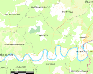
Larnagol
- commune in Lot, France
- Country:
- Postal Code: 46160
- Coordinates: 44° 28' 34" N, 1° 46' 39" E
- GPS tracks (wikiloc): [Link]
- Area: 24.36 sq km
- Population: 133
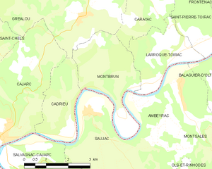
Montbrun
- commune in Lot, France
- Country:
- Postal Code: 46160
- Coordinates: 44° 30' 19" N, 1° 54' 2" E
- GPS tracks (wikiloc): [Link]
- Area: 8.34 sq km
- Population: 96
- Web site: [Link]


Saint-Chels
- commune in Lot, France
- Country:
- Postal Code: 46160
- Coordinates: 44° 31' 44" N, 1° 48' 5" E
- GPS tracks (wikiloc): [Link]
- Area: 17.86 sq km
- Population: 140
- Web site: [Link]


Saint-Pierre-Toirac
- commune in Lot, France
- Country:
- Postal Code: 46160
- Coordinates: 44° 31' 39" N, 1° 57' 14" E
- GPS tracks (wikiloc): [Link]
- Area: 5.83 sq km
- Population: 144
- Web site: [Link]
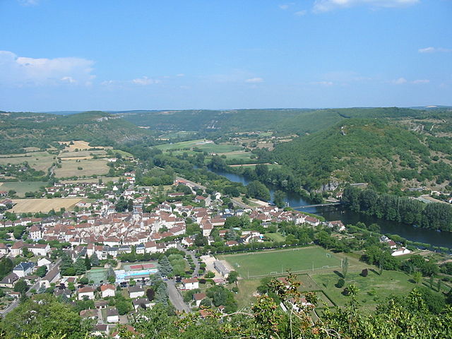
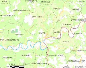
Cajarc
- commune in Lot, France
- Country:
- Postal Code: 46160
- Coordinates: 44° 29' 8" N, 1° 50' 34" E
- GPS tracks (wikiloc): [Link]
- Area: 25.1 sq km
- Population: 1130
- Web site: [Link]

Larroque-Toirac
- commune in Lot, France
- Country:
- Postal Code: 46160
- Coordinates: 44° 31' 18" N, 1° 56' 31" E
- GPS tracks (wikiloc): [Link]
- Area: 6.56 sq km
- Population: 135

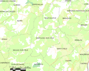
Marcilhac-sur-Célé
- commune in Lot, France
- Country:
- Postal Code: 46160
- Coordinates: 44° 33' 12" N, 1° 46' 15" E
- GPS tracks (wikiloc): [Link]
- Area: 27.35 sq km
- Population: 196
- Web site: [Link]

Gréalou
- commune in Lot, France
- Country:
- Postal Code: 46160
- Coordinates: 44° 32' 11" N, 1° 53' 15" E
- GPS tracks (wikiloc): [Link]
- Area: 17.5 sq km
- Population: 270