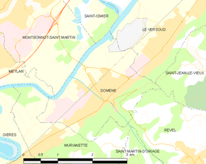
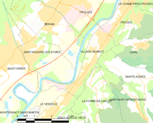
canton of Domène (canton de Domène)
- canton in Grenoble, France
 Hiking in canton of Domène
Canton de Domène, located in the Isère department of the Auvergne-Rhône-Alpes region in France, offers beautiful hiking opportunities amidst stunning alpine scenery. The region is characterized by rolling hills, vibrant forests, and views of the surrounding mountains, including the majestic Chartreuse and Belledonne ranges.
Popular Hiking Trails:
-
Sentier des Cimes:
- This trail provides breathtaking panoramic views and takes you through diverse ecosystems. It's suitable for experienced hikers as it includes some steep sections.
-
Col de la Pra:
- A more challenging hike that leads to a mountain pass, offering incredible vistas. The trail is well-marked but can be steep in parts.
-
Chemin de la Mère Jean:
- A family-friendly route ideal for those looking to enjoy a leisurely hike. It’s often less crowded, allowing for a peaceful nature experience.
-
Les Gorges de l’Isère:
- A scenic route that follows the Isère River, featuring beautiful cliffs and rock formations. This trail is moderately easy and suitable for a wide range of hikers.
Tips for Hiking in Canton de Domène:
- Best Time to Hike: Late spring to early autumn (May to October) is when the weather is generally mild and the trails are most accessible.
- Preparation: Always check the weather forecast before hiking. The alpine climate can change rapidly.
- Gear: Wear proper hiking boots and consider bringing trekking poles, especially for steeper trails. Don’t forget to pack enough water and snacks.
- Navigation: Trails are typically marked, but carrying a map or using a GPS app can be helpful, particularly on less populated paths.
Local Flora and Fauna:
The region is rich in biodiversity. You might encounter various wildflowers, beech and fir forests, and if you're lucky, wildlife such as chamois, marmots, and a variety of birds.
Conservation:
Stay on marked trails to minimize your impact on the fragile environment. Always follow the Leave No Trace principles to preserve the natural beauty for future hikers.
Hiking in Canton de Domène provides a perfect blend of adventure and tranquility, making it an excellent choice for both novice and experienced hikers. Enjoy your outdoor adventure!
- Country:

- Capital: Domène
- Coordinates: 45° 12' 20" N, 5° 52' 47" E


- GPS tracks (wikiloc): [Link]
- Wikidata storage: Wikidata: Q1725166
- INSEE canton code: [3809]
Includes regions:

Domène
- commune in Isère, France
Hiking in Domène
Domène, located in the Isère department in the Auvergne-Rhône-Alpes region of southeastern France, offers picturesque hiking opportunities with stunning views of the surrounding mountains and valleys. Nestled near the Chartreuse and Belledonne mountain ranges, the area boasts a variety of trails suitable for different skill levels, from leisurely walks to more challenging hikes....
- Country:
- Postal Code: 38420
- Coordinates: 45° 12' 9" N, 5° 50' 20" E
- GPS tracks (wikiloc): [Link]
- Area: 5.29 sq km
- Population: 6739
- Web site: [Link]


Revel
- commune in Isère, France
Hiking in Revel
Revel, located in the Isère department of the Auvergne-Rhône-Alpes region in southeastern France, is a fantastic destination for hiking enthusiasts. The area is characterized by its stunning alpine scenery, diverse landscapes, and a variety of trails suitable for different skill levels. Here are some highlights and tips for hiking in Revel:...
- Country:
- Postal Code: 38420
- Coordinates: 45° 11' 9" N, 5° 52' 5" E
- GPS tracks (wikiloc): [Link]
- Area: 29.55 sq km
- Population: 1340
- Web site: [Link]

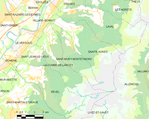
La Combe-de-Lancey
- commune in Isère, France
Hiking in La Combe-de-Lancey
La Combe-de-Lancey, located in the French Alps, is a beautiful destination for hiking enthusiasts. This region is characterized by its stunning landscapes, pristine nature, and a range of trails that cater to various skill levels....
- Country:
- Postal Code: 38190
- Coordinates: 45° 13' 33" N, 5° 53' 52" E
- GPS tracks (wikiloc): [Link]
- Area: 18.55 sq km
- Population: 697
- Web site: [Link]


Le Versoud
- commune in Isère, France
Hiking in Le Versoud
Le Versoud is a charming commune located in the Grenoble metropolitan area of France, nestled in the stunning French Alps. This region offers picturesque landscapes, making it ideal for hiking enthusiasts of all levels. Here are some key points to consider when planning a hiking experience in Le Versoud:...
- Country:
- Postal Code: 38420
- Coordinates: 45° 12' 57" N, 5° 51' 44" E
- GPS tracks (wikiloc): [Link]
- Area: 6.35 sq km
- Population: 4768
- Web site: [Link]


Saint-Martin-d'Uriage
- commune in Isère, France
Hiking in Saint-Martin-d'Uriage
Saint-Martin-d'Uriage is a charming commune located in the Isère department of southeastern France. Nestled at the foothills of the Belledonne mountain range, it offers a variety of hiking opportunities that cater to different skill levels and preferences....
- Country:
- Postal Code: 38410
- Coordinates: 45° 9' 8" N, 5° 50' 21" E
- GPS tracks (wikiloc): [Link]
- Area: 29.69 sq km
- Population: 5408
- Web site: [Link]


Saint-Mury-Monteymond
- commune in Isère, France
Hiking in Saint-Mury-Monteymond
Saint-Mury-Monteymond is a picturesque commune located in the Auvergne-Rhône-Alpes region of France, nestled in the beautiful Isère department. The area is characterized by its stunning natural landscapes, making it an excellent destination for hiking enthusiasts....
- Country:
- Postal Code: 38190
- Coordinates: 45° 13' 21" N, 5° 55' 37" E
- GPS tracks (wikiloc): [Link]
- Area: 11.09 sq km
- Population: 330
- Web site: [Link]

Laval
- commune in Isère, France
Hiking in Laval
Laval, located in the Isère department of the Auvergne-Rhône-Alpes region in France, is surrounded by stunning natural landscapes that provide excellent hiking opportunities. Here are some key points about hiking in and around Laval, Isère:...
- Country:
- Postal Code: 38190
- Coordinates: 45° 15' 11" N, 5° 55' 57" E
- GPS tracks (wikiloc): [Link]
- Area: 25.33 sq km
- Population: 988
- Web site: [Link]

Sainte-Agnès
- commune in Isère, France
Hiking in Sainte-Agnès
Sainte-Agnès, located in the Isère department in the Auvergne-Rhône-Alpes region of France, offers a variety of hiking opportunities that showcase stunning alpine scenery, lush meadows, and charming mountain villages. Here are some insights into hiking in this beautiful area:...
- Country:
- Postal Code: 38190
- Coordinates: 45° 14' 12" N, 5° 55' 16" E
- GPS tracks (wikiloc): [Link]
- Area: 26.85 sq km
- Population: 567
- Web site: [Link]


Murianette
- commune in Isère, France
Hiking in Murianette
Murianette is a beautiful area located in the region of Piedmont, Italy, near the city of Turin. It offers a variety of hiking trails that showcase stunning landscapes, lush greenery, and a rich diversity of flora and fauna. Here are a few key points about hiking in the Murianette area:...
- Country:
- Postal Code: 38420
- Coordinates: 45° 11' 30" N, 5° 49' 13" E
- GPS tracks (wikiloc): [Link]
- Area: 6.07 sq km
- Population: 886
- Web site: [Link]


Saint-Jean-le-Vieux
- commune in Isère, France
Hiking in Saint-Jean-le-Vieux
Saint-Jean-le-Vieux, located in the Isère department of the Auvergne-Rhône-Alpes region in southeastern France, offers some beautiful hiking opportunities set against a backdrop of stunning landscapes. The area is characterized by its mountainous terrain, lush forests, and picturesque valleys, making it ideal for outdoor enthusiasts....
- Country:
- Postal Code: 38420
- Coordinates: 45° 12' 44" N, 5° 52' 53" E
- GPS tracks (wikiloc): [Link]
- Area: 4.59 sq km
- Population: 279
- Web site: [Link]

Villard-Bonnot
- commune in Isère, France
Hiking in Villard-Bonnot
Villard-Bonnot, located in the French Alps near Grenoble, offers an excellent opportunity for hiking enthusiasts. With its picturesque landscapes, diverse trails, and stunning mountain views, the area is appealing to both beginners and experienced hikers....
- Country:
- Postal Code: 38190
- Coordinates: 45° 14' 17" N, 5° 53' 18" E
- GPS tracks (wikiloc): [Link]
- Area: 5.84 sq km
- Population: 7096
- Web site: [Link]