Canton of Douvaine (canton de Douvaine)
- canton of France (until March 2015)
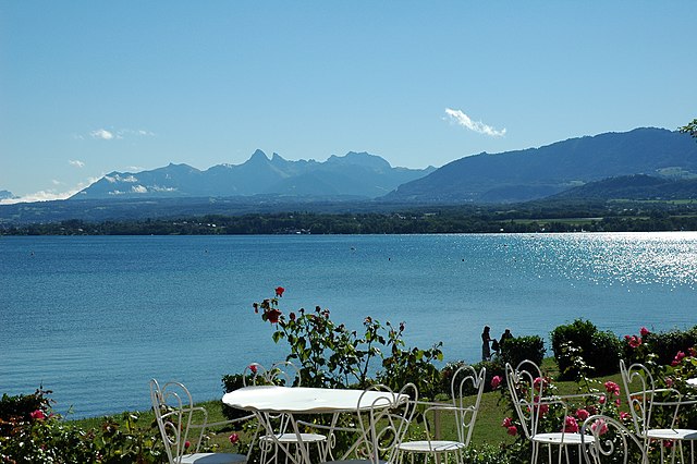
 Hiking in Canton of Douvaine
Canton de Douvaine, located in the Haute-Savoie region of France, offers beautiful landscapes and a variety of hiking opportunities for outdoor enthusiasts. Here are some highlights and tips for hiking in this area:
Scenic Routes and Trails
-
Le Mont Salève: Just a short distance from Douvaine, this mountain offers several trails with breathtaking views of Lake Geneva and the surrounding Alps. You can hike to the summit or explore the lower trails which are more suitable for beginners.
-
The Vallée Verte: This picturesque valley is great for leisurely walks and hiking. There are multiple trails that weave through charming villages, past farms, and alongside forests and rivers.
-
Les Voirons Mountains: These mountains provide diverse hiking paths with varying difficulty levels. Whether you want a gentle stroll or a more challenging hike, you can find routes that fit your preferences.
-
Surrounding Lakes: The area is dotted with lakes, such as Lake Geneva and Lake Vallon, which offer not only scenic views but also opportunities for water activities. Hiking around these lakes can be particularly rewarding.
Tips for Hiking
-
Seasonal Considerations: The best time to hike in Canton de Douvaine is during spring and fall when the weather is mild and the scenery is vibrant. Summer can be hot, while winter will bring snow to higher elevations.
-
Preparation: Always check the weather forecast before heading out and dress in layers. Good hiking boots and a map or GPS device are essential for safety.
-
Local Guides: If you're unfamiliar with the area, consider hiring a local guide who can provide insights and ensure you don’t miss hidden gems.
-
Wildlife and Nature: The region is home to diverse flora and fauna, so keep an eye out for local wildlife. Respect the natural environment by sticking to marked trails and following Leave No Trace principles.
-
Hydration and Nutrition: Carry enough water and snacks to stay energized during your hikes, especially on longer trails.
Accessibility
Canton de Douvaine is accessible by car and public transport, making it easy to reach the various hiking trails. Local resources, such as tourist offices, can provide detailed maps and trail information.
Whether you're a seasoned hiker or a novice looking to enjoy the stunning Alpine scenery, Canton de Douvaine has something for everyone. Happy hiking!
- Country:

- Capital: Douvaine
- Coordinates: 46° 18' 39" N, 6° 20' 2" E


- GPS tracks (wikiloc): [Link]
- Wikidata storage: Wikidata: Q970841
Includes regions:


Massongy
- commune in Haute-Savoie, France
Hiking in Massongy
Massongy is a charming small village located in the Auvergne-Rhône-Alpes region of France, known for its picturesque landscapes and outdoor activities, including hiking. The area features beautiful landscapes with varying terrain, making it suitable for hikers of all skill levels....
- Country:
- Postal Code: 74140
- Coordinates: 46° 18' 58" N, 6° 20' 1" E
- GPS tracks (wikiloc): [Link]
- Area: 9.81 sq km
- Population: 1568
- Web site: [Link]


Brenthonne
- commune in Haute-Savoie, France
Hiking in Brenthonne
Brenthonne is a charming village located in the Haute-Savoie region of France, close to the shores of Lake Geneva. It is surrounded by stunning natural landscapes, making it a great area for hiking enthusiasts....
- Country:
- Postal Code: 74890
- Coordinates: 46° 16' 24" N, 6° 23' 38" E
- GPS tracks (wikiloc): [Link]
- Area: 8.38 sq km
- Population: 991

Ballaison
- commune in Haute-Savoie, France
Hiking in Ballaison
Ballaison is a charming village located in the Auvergne-Rhône-Alpes region of France, near the shores of Lake Geneva and close to the Swiss border. Hiking in and around Ballaison offers a variety of landscapes and experiences, from lakeside strolls to more challenging mountain trails....
- Country:
- Postal Code: 74140
- Coordinates: 46° 17' 57" N, 6° 19' 45" E
- GPS tracks (wikiloc): [Link]
- Area: 13.3 sq km
- Population: 1488


Chens-sur-Léman
- commune in Haute-Savoie, France
Hiking in Chens-sur-Léman
Chens-sur-Léman is a picturesque village located in the Haute-Savoie region of France, near the shores of Lake Geneva. The surrounding area offers a variety of hiking opportunities that cater to different skill levels and preferences. Here are some highlights of hiking in and around Chens-sur-Léman:...
- Country:
- Postal Code: 74140
- Coordinates: 46° 19' 41" N, 6° 16' 7" E
- GPS tracks (wikiloc): [Link]
- Area: 10.87 sq km
- Population: 2531


Douvaine
- commune in Haute-Savoie, France
Hiking in Douvaine
Douvaine, located in the Haute-Savoie region of France near the border with Switzerland, is a charming town that offers various opportunities for hiking enthusiasts. The surrounding area features beautiful landscapes, including lakes, forests, and mountainous terrain, making it a fantastic location for outdoor activities....
- Country:
- Postal Code: 74140
- Coordinates: 46° 18' 18" N, 6° 18' 13" E
- GPS tracks (wikiloc): [Link]
- Area: 10.54 sq km
- Population: 5716
- Web site: [Link]

Excenevex
- commune in Haute-Savoie, France
Hiking in Excenevex
Excenevex is a charming village located on the shores of Lake Geneva in the Haute-Savoie region of France. This area offers a beautiful setting for hiking, with a blend of lakeside trails and mountainous terrain nearby. Here are some key points about hiking in Excenevex:...
- Country:
- Postal Code: 74140
- Coordinates: 46° 21' 13" N, 6° 21' 14" E
- GPS tracks (wikiloc): [Link]
- Area: 6.66 sq km
- Population: 1097
- Web site: [Link]
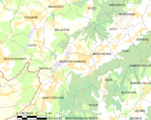
Bons-en-Chablais
- commune in Haute-Savoie, France
Hiking in Bons-en-Chablais
Bons-en-Chablais is a charming commune located in the Haute-Savoie region of the French Alps. Its proximity to both the mountains and Lake Geneva makes it an excellent location for hiking enthusiasts. Here are some highlights and tips for hiking in the area:...
- Country:
- Postal Code: 74890
- Coordinates: 46° 15' 52" N, 6° 22' 13" E
- GPS tracks (wikiloc): [Link]
- Area: 19.09 sq km
- Population: 5456
- Web site: [Link]


Fessy
- commune in Haute-Savoie, France
Hiking in Fessy
Fessy, located in the Haute-Savoie region of France, offers beautiful hiking opportunities with stunning views of the surrounding Alpine landscape. Here are some key points to know before you head out for hiking in this area:...
- Country:
- Postal Code: 74890
- Coordinates: 46° 16' 32" N, 6° 24' 41" E
- GPS tracks (wikiloc): [Link]
- Area: 8.53 sq km
- Population: 890


Yvoire
- commune in Haute-Savoie, France
Hiking in Yvoire
Yvoire is a charming medieval village located on the shores of Lake Geneva in France. While it is more renowned for its picturesque streets and historical architecture, the surrounding area offers some excellent opportunities for hiking and enjoying the natural beauty of the region....
- Country:
- Postal Code: 74140
- Coordinates: 46° 22' 12" N, 6° 19' 36" E
- GPS tracks (wikiloc): [Link]
- Area: 3.12 sq km
- Population: 953
- Web site: [Link]


Veigy-Foncenex
- commune in Haute-Savoie, France
Hiking in Veigy-Foncenex
Veigy-Foncenex is a picturesque commune located in the Haute-Savoie region of France, near the shores of Lake Geneva and close to the Swiss border. While it may not be as famous as some larger hiking destinations in the Alps, it offers several opportunities for enjoyable hikes and outdoor activities, primarily for those looking for scenic views and peaceful nature walks....
- Country:
- Postal Code: 74140
- Coordinates: 46° 16' 19" N, 6° 15' 32" E
- GPS tracks (wikiloc): [Link]
- Area: 12.99 sq km
- Population: 3418
- Web site: [Link]


Nernier
- commune in Haute-Savoie, France
Hiking in Nernier
Nernier, located on the shores of Lake Geneva in the Haute-Savoie region of France, offers picturesque views and a tranquil environment, making it a lovely spot for hiking enthusiasts. While the village itself is small and primarily residential, surrounding areas offer a variety of trails and natural beauty....
- Country:
- Postal Code: 74140
- Coordinates: 46° 21' 56" N, 6° 18' 13" E
- GPS tracks (wikiloc): [Link]
- Area: 1.82 sq km
- Population: 409


Lully
- commune in Haute-Savoie, France
Hiking in Lully
Lully, a charming village in Haute-Savoie, France, offers a range of hiking opportunities that showcase the stunning beauty of the French Alps. Here’s what you can expect when hiking in this region:...
- Country:
- Postal Code: 74890
- Coordinates: 46° 17' 0" N, 6° 24' 56" E
- GPS tracks (wikiloc): [Link]
- Area: 4.86 sq km
- Population: 725
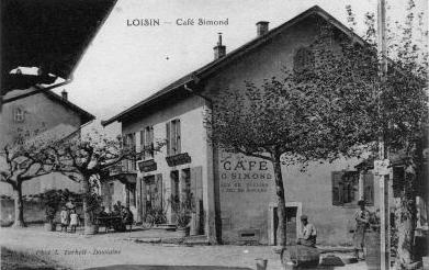

Loisin
- commune in Haute-Savoie, France
Hiking in Loisin
Loisin, located in the Haute-Savoie region of France, offers beautiful landscapes and a variety of hiking opportunities that cater to different skill levels. The region is characterized by its stunning alpine scenery, charming villages, and diverse flora and fauna....
- Country:
- Postal Code: 74140
- Coordinates: 46° 17' 30" N, 6° 18' 37" E
- GPS tracks (wikiloc): [Link]
- Area: 7.86 sq km
- Population: 1495
- Web site: [Link]

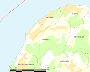
Messery
- commune in Haute-Savoie, France
Hiking in Messery
Messery, located in the Haute-Savoie region of France near the shores of Lake Geneva, offers stunning landscapes and a variety of hiking opportunities. The area's natural beauty, with its rolling hills, views of the Alps, and proximity to the lake, makes it an appealing destination for hikers of all levels....
- Country:
- Postal Code: 74140
- Coordinates: 46° 21' 4" N, 6° 17' 30" E
- GPS tracks (wikiloc): [Link]
- Area: 9.22 sq km
- Population: 2192
- Web site: [Link]