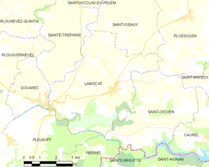
canton of Gouarec (canton de Gouarec)
.png)
- canton of France
- Country:

- Capital: Gouarec
- Coordinates: 48° 13' 39" N, 3° 10' 44" E


- GPS tracks (wikiloc): [Link]
- Wikidata storage: Wikidata: Q1725386
- Library of Congress authority ID: Alt: [no2012161915]
- INSEE canton code: [2215]
Includes regions:


Perret
- former commune in Côtes-d'Armor, France
- Country:
- Postal Code: 22570
- Coordinates: 48° 10' 35" N, 3° 9' 35" E
- GPS tracks (wikiloc): [Link]
- Area: 12.22 sq km
- Population: 184


Saint-Gelven
- former commune in Côtes-d'Armor, France
- Country:
- Postal Code: 22570
- Coordinates: 48° 13' 35" N, 3° 5' 50" E
- GPS tracks (wikiloc): [Link]
- Area: 17.48 sq km
- Population: 319

Laniscat
- former commune in Côtes-d'Armor, France
- Country:
- Postal Code: 22570
- Coordinates: 48° 14' 30" N, 3° 7' 24" E
- GPS tracks (wikiloc): [Link]
- Area: 24.21 sq km
- Population: 771
- Web site: [Link]