canton of Guîtres (canton de Guîtres)
- canton of France (until March 2015)
- Country:

- Capital: Guîtres
- Coordinates: 45° 2' 28" N, 0° 13' 59" E


- GPS tracks (wikiloc): [Link]
- Wikidata storage: Wikidata: Q1447448
- Library of Congress authority ID: Alt: [n96010679]
- INSEE canton code: [3326]
Includes regions:

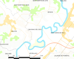
Savignac-de-l'Isle
- commune in Gironde, France
- Country:
- Postal Code: 33910
- Coordinates: 44° 59' 24" N, 0° 14' 7" E
- GPS tracks (wikiloc): [Link]
- AboveSeaLevel: 15 м m
- Area: 4.47 sq km
- Population: 505
- Web site: [Link]

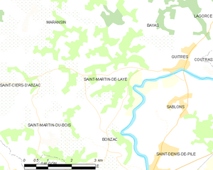
Saint-Martin-de-Laye
- commune in Gironde, France
- Country:
- Postal Code: 33910
- Coordinates: 45° 2' 7" N, 0° 13' 40" E
- GPS tracks (wikiloc): [Link]
- Area: 9.56 sq km
- Population: 541


Lagorce
- commune in Gironde, France
- Country:
- Postal Code: 33230
- Coordinates: 45° 4' 54" N, 0° 9' 54" E
- GPS tracks (wikiloc): [Link]
- Area: 28.47 sq km
- Population: 1681
- Web site: [Link]


Tizac-de-Lapouyade
- commune in Gironde, France
- Country:
- Postal Code: 33620
- Coordinates: 45° 4' 24" N, 0° 18' 19" E
- GPS tracks (wikiloc): [Link]
- Area: 9.4 sq km
- Population: 491


Lapouyade
- commune in Gironde, France
- Country:
- Postal Code: 33620
- Coordinates: 45° 5' 10" N, 0° 17' 13" E
- GPS tracks (wikiloc): [Link]
- Area: 25.8 sq km
- Population: 500
- Web site: [Link]


Bayas
- commune in Gironde, France
- Country:
- Postal Code: 33230
- Coordinates: 45° 3' 38" N, 0° 12' 25" E
- GPS tracks (wikiloc): [Link]
- Area: 10.82 sq km
- Population: 443

Bonzac
- commune in Gironde, France
- Country:
- Postal Code: 33910
- Coordinates: 45° 0' 25" N, 0° 13' 20" E
- GPS tracks (wikiloc): [Link]
- Area: 7.49 sq km
- Population: 756


Saint-Martin-du-Bois
- commune in Gironde, France
- Country:
- Postal Code: 33910
- Coordinates: 45° 1' 33" N, 0° 16' 1" E
- GPS tracks (wikiloc): [Link]
- Area: 9.8 sq km
- Population: 860


Sablons
- commune in Gironde, France
- Country:
- Postal Code: 33910
- Coordinates: 45° 1' 32" N, 0° 11' 37" E
- GPS tracks (wikiloc): [Link]
- Area: 11.84 sq km
- Population: 1350


Maransin
- commune in Gironde, France
- Country:
- Postal Code: 33230
- Coordinates: 45° 4' 16" N, 0° 16' 5" E
- GPS tracks (wikiloc): [Link]
- Area: 29.94 sq km
- Population: 1026


Saint-Ciers-d'Abzac
- commune in Gironde, France
- Country:
- Postal Code: 33910
- Coordinates: 45° 1' 52" N, 0° 16' 37" E
- GPS tracks (wikiloc): [Link]
- Area: 11.71 sq km
- Population: 1394

Saint-Denis-de-Pile
- commune in Gironde, France
- Country:
- Postal Code: 33910
- Coordinates: 44° 59' 30" N, 0° 12' 22" E
- GPS tracks (wikiloc): [Link]
- Area: 28.27 sq km
- Population: 5302


Guîtres
- commune in Gironde, France
- Country:
- Postal Code: 33230
- Coordinates: 45° 2' 0" N, 0° 11' 0" E
- GPS tracks (wikiloc): [Link]
- Area: 5.02 sq km
- Population: 1611