canton of La Chaise-Dieu (canton de La Chaise-Dieu)
- canton of France (until March 2015)
- Country:

- Capital: La Chaise-Dieu
- Coordinates: 45° 19' 12" N, 3° 42' 0" E


- GPS tracks (wikiloc): [Link]
- Wikidata storage: Wikidata: Q249472
- INSEE canton code: [4307]
Includes regions:


Bonneval
- commune in Haute-Loire, France
- Country:
- Postal Code: 43160
- Coordinates: 45° 18' 42" N, 3° 44' 29" E
- GPS tracks (wikiloc): [Link]
- Area: 14.66 sq km
- Population: 75

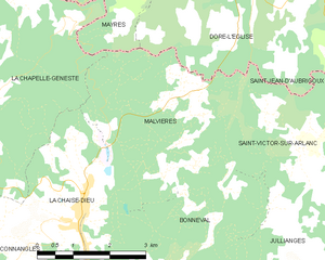
Malvières
- commune in Haute-Loire, France
- Country:
- Postal Code: 43160
- Coordinates: 45° 20' 14" N, 3° 43' 56" E
- GPS tracks (wikiloc): [Link]
- Area: 13.72 sq km
- Population: 137


Laval-sur-Doulon
- commune in Haute-Loire, France
- Country:
- Postal Code: 43440
- Coordinates: 45° 21' 6" N, 3° 33' 41" E
- GPS tracks (wikiloc): [Link]
- Area: 12.28 sq km
- Population: 64


Félines
- commune in Haute-Loire, France
- Country:
- Postal Code: 43160
- Coordinates: 45° 16' 20" N, 3° 44' 36" E
- GPS tracks (wikiloc): [Link]
- Area: 20.5 sq km
- Population: 301


Sembadel
- commune in Haute-Loire, France
- Country:
- Postal Code: 43160
- Coordinates: 45° 16' 29" N, 3° 41' 12" E
- GPS tracks (wikiloc): [Link]
- Area: 18.59 sq km
- Population: 231
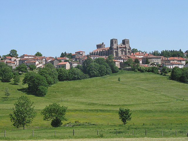

La Chaise-Dieu
- commune in Haute-Loire, France
- Country:
- Postal Code: 43160
- Coordinates: 45° 19' 17" N, 3° 41' 48" E
- GPS tracks (wikiloc): [Link]
- AboveSeaLevel: 1082 м m
- Area: 13.58 sq km
- Population: 619
- Web site: [Link]


Saint-Pal-de-Senouire
- commune in Haute-Loire, France
- Country:
- Postal Code: 43160
- Coordinates: 45° 15' 33" N, 3° 39' 3" E
- GPS tracks (wikiloc): [Link]
- Area: 18.35 sq km
- Population: 109
- Web site: [Link]


Connangles
- commune in Haute-Loire, France
- Country:
- Postal Code: 43160
- Coordinates: 45° 17' 56" N, 3° 38' 50" E
- GPS tracks (wikiloc): [Link]
- Area: 21.89 sq km
- Population: 148
Berbezit
- commune in Haute-Loire, France
- Country:
- Postal Code: 43160
- Coordinates: 45° 17' 5" N, 3° 35' 42" E
- GPS tracks (wikiloc): [Link]
- Area: 10.39 sq km
- Population: 51


Cistrières
- commune in Haute-Loire, France
- Country:
- Postal Code: 43160
- Coordinates: 45° 19' 18" N, 3° 37' 17" E
- GPS tracks (wikiloc): [Link]
- Area: 21.89 sq km
- Population: 142
La Chapelle-Geneste
- commune in Haute-Loire, France
- Country:
- Postal Code: 43160
- Coordinates: 45° 20' 59" N, 3° 40' 3" E
- GPS tracks (wikiloc): [Link]
- Area: 18.06 sq km
- Population: 113