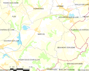
canton of La Chartre-sur-le-Loir (canton de La Chartre-sur-le-Loir)
- canton of France
- Country:

- Capital: La Chartre-sur-le-Loir
- Coordinates: 47° 44' 49" N, 0° 35' 54" E


- GPS tracks (wikiloc): [Link]
- Wikidata storage: Wikidata: Q1725590
- INSEE canton code: [7206]
Includes regions:

Chahaignes
- commune in Sarthe, France
- Country:
- Postal Code: 72340
- Coordinates: 47° 44' 31" N, 0° 30' 54" E
- GPS tracks (wikiloc): [Link]
- Area: 22.83 sq km
- Population: 710
Lavenay
- former commune in Sarthe, France
- Country:
- Postal Code: 72310
- Coordinates: 47° 47' 26" N, 0° 42' 5" E
- GPS tracks (wikiloc): [Link]
- Area: 7.7 sq km
- Population: 346


Lhomme
- commune in Sarthe, France
- Country:
- Postal Code: 72340
- Coordinates: 47° 44' 37" N, 0° 33' 32" E
- GPS tracks (wikiloc): [Link]
- Area: 18.32 sq km
- Population: 889
- Web site: [Link]
La Chapelle-Gaugain
- former commune in Sarthe, France
- Country:
- Postal Code: 72310
- Coordinates: 47° 47' 56" N, 0° 40' 50" E
- GPS tracks (wikiloc): [Link]
- Area: 10.66 sq km
- Population: 291
Beaumont-sur-Dême
- commune in Sarthe, France
- Country:
- Postal Code: 72340
- Coordinates: 47° 41' 40" N, 0° 34' 9" E
- GPS tracks (wikiloc): [Link]
- Area: 13.49 sq km
- Population: 343

Marçon
- commune in Sarthe, France
- Country:
- Postal Code: 72340
- Coordinates: 47° 42' 34" N, 0° 30' 41" E
- GPS tracks (wikiloc): [Link]
- Area: 30.05 sq km
- Population: 1039

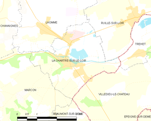
La Chartre-sur-le-Loir
- commune in Sarthe, France
- Country:
- Postal Code: 72340
- Coordinates: 47° 43' 44" N, 0° 34' 23" E
- GPS tracks (wikiloc): [Link]
- Area: 8.3 sq km
- Population: 1455
- Web site: [Link]


Ruillé-sur-Loir
- former commune in Sarthe, France
- Country:
- Postal Code: 72340
- Coordinates: 47° 45' 2" N, 0° 37' 14" E
- GPS tracks (wikiloc): [Link]
- Area: 39.48 sq km
- Population: 1207

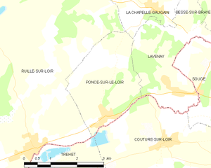
Poncé-sur-le-Loir
- former commune in Sarthe, France
- Country:
- Postal Code: 72340
- Coordinates: 47° 45' 43" N, 0° 39' 19" E
- GPS tracks (wikiloc): [Link]
- Area: 6.92 sq km
- Population: 342