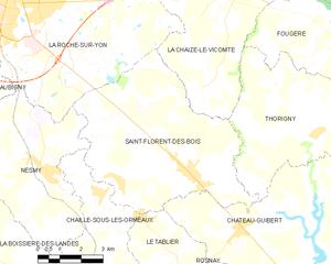
canton of La Roche-sur-Yon-Sud (canton de La Roche-sur-Yon-Sud)
- canton of France (until March 2015)
- Country:

- Capital: La Roche-sur-Yon
- Coordinates: 46° 37' 32" N, 1° 26' 28" E


- GPS tracks (wikiloc): [Link]
- Wikidata storage: Wikidata: Q673179
- INSEE canton code: [8531]
Includes regions:


Aubigny
- former commune in Vendée, France
- Country:
- Postal Code: 85430
- Coordinates: 46° 35' 48" N, 1° 27' 14" E
- GPS tracks (wikiloc): [Link]
- Area: 25.79 sq km
- Population: 3681
- Web site: [Link]


La Chaize-le-Vicomte
- commune in Vendée, France
- Country:
- Postal Code: 85310
- Coordinates: 46° 40' 20" N, 1° 17' 33" E
- GPS tracks (wikiloc): [Link]
- Area: 49.51 sq km
- Population: 3708
- Web site: [Link]


Fougeré
- commune in Vendée, France
- Country:
- Postal Code: 85480
- Coordinates: 46° 39' 30" N, 1° 13' 57" E
- GPS tracks (wikiloc): [Link]
- Area: 26.89 sq km
- Population: 1180
- Web site: [Link]


Les Clouzeaux
- former commune in Vendée, France
- Country:
- Postal Code: 85430
- Coordinates: 46° 37' 48" N, 1° 30' 31" E
- GPS tracks (wikiloc): [Link]
- Area: 26.49 sq km
- Population: 2604
- Web site: [Link]


Le Tablier
- commune in Vendée, France
- Country:
- Postal Code: 85310
- Coordinates: 46° 34' 29" N, 1° 20' 37" E
- GPS tracks (wikiloc): [Link]
- AboveSeaLevel: 40 м m
- Area: 9.28 sq km
- Population: 749
- Web site: [Link]


Thorigny
- commune in Vendée, France
- Country:
- Postal Code: 85480
- Coordinates: 46° 36' 43" N, 1° 14' 23" E
- GPS tracks (wikiloc): [Link]
- Area: 32.15 sq km
- Population: 1229
- Web site: [Link]

Saint-Florent-des-Bois
- former commune in Vendée, France
- Country:
- Postal Code: 85310
- Coordinates: 46° 35' 37" N, 1° 18' 57" E
- GPS tracks (wikiloc): [Link]
- Area: 36.76 sq km
- Population: 2813
- Web site: [Link]


Nesmy
- commune in Vendée, France
- Country:
- Postal Code: 85310
- Coordinates: 46° 35' 27" N, 1° 24' 3" E
- GPS tracks (wikiloc): [Link]
- Area: 24.52 sq km
- Population: 2832
- Web site: [Link]
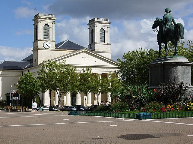

La Roche-sur-Yon
- commune in Vendée, France
- Country:
- Postal Code: 85000
- Coordinates: 46° 40' 11" N, 1° 25' 40" E
- GPS tracks (wikiloc): [Link]
- AboveSeaLevel: 74 м m
- Area: 87.52 sq km
- Population: 53578
- Web site: [Link]

Chaillé-sous-les-Ormeaux
- former commune in Vendée, France
- Country:
- Postal Code: 85310
- Coordinates: 46° 35' 0" N, 1° 22' 7" E
- GPS tracks (wikiloc): [Link]
- AboveSeaLevel: 60 м m
- Area: 17.5 sq km
- Population: 1335
- Web site: [Link]