canton of Puymirol (canton de Puymirol)
- canton of France
- Country:

- Capital: Puymirol
- Coordinates: 44° 11' 16" N, 0° 47' 54" E


- GPS tracks (wikiloc): [Link]
- Wikidata storage: Wikidata: Q1726842
- INSEE canton code: [4729]
Includes regions:


Castelculier
- commune in Lot-et-Garonne, France
- Country:
- Postal Code: 47240
- Coordinates: 44° 10' 28" N, 0° 41' 34" E
- GPS tracks (wikiloc): [Link]
- Area: 14.95 sq km
- Population: 2342
- Web site: [Link]
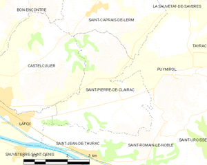
Saint-Pierre-de-Clairac
- commune in Lot-et-Garonne, France
- Country:
- Postal Code: 47270
- Coordinates: 44° 10' 46" N, 0° 45' 39" E
- GPS tracks (wikiloc): [Link]
- Area: 13.15 sq km
- Population: 889
- Web site: [Link]

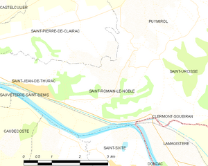
Saint-Romain-le-Noble
- commune in Lot-et-Garonne, France
- Country:
- Postal Code: 47270
- Coordinates: 44° 9' 44" N, 0° 47' 7" E
- GPS tracks (wikiloc): [Link]
- Area: 8.5 sq km
- Population: 447


Lafox
- commune in Lot-et-Garonne, France
- Country:
- Postal Code: 47240
- Coordinates: 44° 10' 7" N, 0° 42' 4" E
- GPS tracks (wikiloc): [Link]
- Area: 5.23 sq km
- Population: 1143
- Web site: [Link]

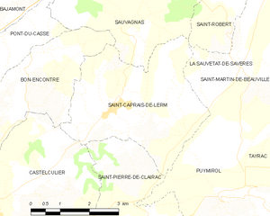
Saint-Caprais-de-Lerm
- commune in Lot-et-Garonne, France
- Country:
- Postal Code: 47270
- Coordinates: 44° 12' 47" N, 0° 44' 37" E
- GPS tracks (wikiloc): [Link]
- Area: 13.6 sq km
- Population: 644
- Web site: [Link]


Saint-Urcisse
- commune in Lot-et-Garonne, France
- Country:
- Postal Code: 47270
- Coordinates: 44° 9' 39" N, 0° 49' 6" E
- GPS tracks (wikiloc): [Link]
- Area: 10.93 sq km
- Population: 227
- Web site: [Link]
Grayssas
- commune in Lot-et-Garonne, France
- Country:
- Postal Code: 47270
- Coordinates: 44° 9' 54" N, 0° 52' 28" E
- GPS tracks (wikiloc): [Link]
- Area: 9.37 sq km
- Population: 131

Clermont-Soubiran
- commune in Lot-et-Garonne, France
- Country:
- Postal Code: 47270
- Coordinates: 44° 8' 26" N, 0° 49' 55" E
- GPS tracks (wikiloc): [Link]
- AboveSeaLevel: 103 м m
- Area: 10.39 sq km
- Population: 376


Puymirol
- commune in Lot-et-Garonne, France
- Country:
- Postal Code: 47270
- Coordinates: 44° 11' 13" N, 0° 47' 51" E
- GPS tracks (wikiloc): [Link]
- Area: 19.54 sq km
- Population: 938
- Web site: [Link]


Saint-Jean-de-Thurac
- commune in Lot-et-Garonne, France
- Country:
- Postal Code: 47270
- Coordinates: 44° 9' 14" N, 0° 44' 35" E
- GPS tracks (wikiloc): [Link]
- Area: 5.12 sq km
- Population: 539