canton of Saint-Arnoult-en-Yvelines (canton de Saint-Arnoult-en-Yvelines)
- canton of France
- Country:

- Capital: Saint-Arnoult-en-Yvelines
- Coordinates: 48° 32' 56" N, 1° 55' 7" E


- GPS tracks (wikiloc): [Link]
- Area: 286 sq km
- Wikidata storage: Wikidata: Q1727064
- Wikipedia Commons Category: [Link]
- Library of Congress authority ID: Alt: [n91115032]
- INSEE canton code: [7819]
Includes regions:
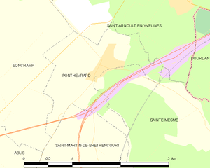
Ponthévrard
- commune in Yvelines, France
- Country:
- Postal Code: 78730
- Coordinates: 48° 33' 5" N, 1° 54' 36" E
- GPS tracks (wikiloc): [Link]
- Area: 2.57 sq km
- Population: 622
- Web site: [Link]

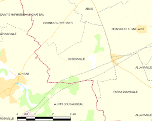
Orsonville
- commune in Yvelines, France
- Country:
- Postal Code: 78660
- Coordinates: 48° 28' 40" N, 1° 50' 7" E
- GPS tracks (wikiloc): [Link]
- AboveSeaLevel: 150 м m
- Area: 9.61 sq km
- Population: 335


Paray-Douaville
- commune in Yvelines, France
- Country:
- Postal Code: 78660
- Coordinates: 48° 27' 49" N, 1° 52' 39" E
- GPS tracks (wikiloc): [Link]
- Area: 10.28 sq km
- Population: 257


Prunay-en-Yvelines
- commune in Yvelines, France
- Country:
- Postal Code: 78660
- Coordinates: 48° 31' 41" N, 1° 47' 43" E
- GPS tracks (wikiloc): [Link]
- AboveSeaLevel: 150 м m
- Area: 26.95 sq km
- Population: 839
- Web site: [Link]

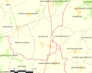
Allainville
- commune in Yvelines, France
- Country:
- Postal Code: 78660
- Coordinates: 48° 27' 26" N, 1° 53' 47" E
- GPS tracks (wikiloc): [Link]
- Area: 16.3 sq km
- Population: 305


Clairefontaine-en-Yvelines
- commune in Yvelines, France
- Country:
- Postal Code: 78120
- Coordinates: 48° 36' 45" N, 1° 54' 29" E
- GPS tracks (wikiloc): [Link]
- AboveSeaLevel: 128 м m
- Area: 17.22 sq km
- Population: 827
- Web site: [Link]


Sonchamp
- commune in Yvelines, France
- Country:
- Postal Code: 78120
- Coordinates: 48° 34' 33" N, 1° 52' 40" E
- GPS tracks (wikiloc): [Link]
- Area: 46.49 sq km
- Population: 1641


Saint-Arnoult-en-Yvelines
- commune in Yvelines, France
- Country:
- Postal Code: 78730
- Coordinates: 48° 34' 18" N, 1° 56' 26" E
- GPS tracks (wikiloc): [Link]
- AboveSeaLevel: 104 м m
- Area: 12.55 sq km
- Population: 6086
- Web site: [Link]


Rochefort-en-Yvelines
- commune in Yvelines, France
- Country:
- Postal Code: 78730
- Coordinates: 48° 35' 9" N, 1° 59' 16" E
- GPS tracks (wikiloc): [Link]
- Area: 12.59 sq km
- Population: 885
- Web site: [Link]


Sainte-Mesme
- commune in Yvelines, France
- Country:
- Postal Code: 78730
- Coordinates: 48° 31' 50" N, 1° 57' 32" E
- GPS tracks (wikiloc): [Link]
- Area: 8.16 sq km
- Population: 920


Saint-Martin-de-Bréthencourt
- commune in Yvelines, France
- Country:
- Postal Code: 78660
- Coordinates: 48° 30' 34" N, 1° 55' 39" E
- GPS tracks (wikiloc): [Link]
- AboveSeaLevel: 140 м m
- Area: 16.67 sq km
- Population: 649