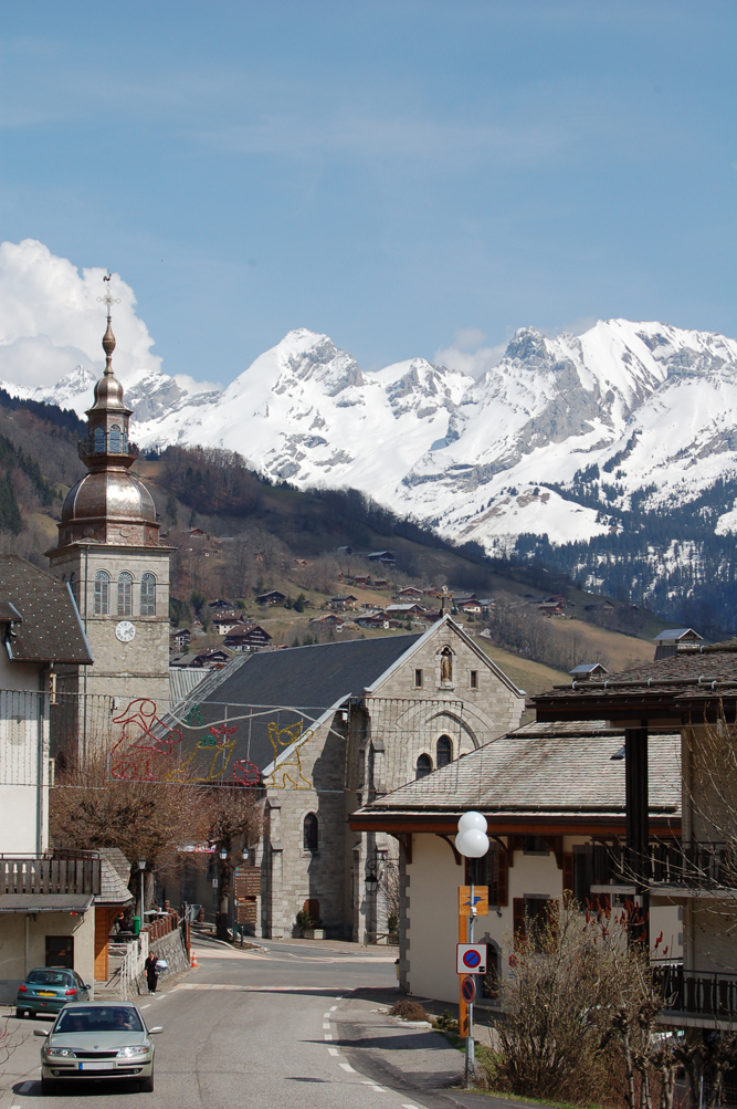
Canton of Thônes (canton de Thônes)
- canton of France
 Hiking in Canton of Thônes
Canton de Thônes, located in the Haute-Savoie region of the French Alps, offers a splendid array of hiking opportunities. The region is characterized by its stunning alpine scenery, lush valleys, and charming mountain villages, making it a perfect destination for outdoor enthusiasts and nature lovers.
Key Highlights of Hiking in Canton de Thônes:
-
Diverse Trails: There are numerous trails ranging from easy walks suitable for families to more challenging routes for experienced hikers. Popular trails include the paths around Lake Thônes and the trails leading to the nearby Aravis mountain range.
-
Scenic Beauty: The hikes often feature breathtaking views of the surrounding mountains, valleys, and lakes. You might encounter picturesque spots like the Col des Aravis or the impressive Mont Blanc in the distance.
-
Flora and Fauna: The region is rich in biodiversity. Hikers can encounter a variety of wildlife, including deer, ibex, and numerous bird species. The flora is equally impressive, with alpine flowers adorning the trails.
-
Cultural Experience: Hiking in Canton de Thônes also provides an opportunity to explore traditional alpine villages and local culture. Enjoy authentic Savoyard cuisine at mountain refuges or in small hamlets along the routes.
-
Accessibility: The area is well-connected with signposted trails and maps available at tourist information centers. Many trails start from easily accessible points, making it convenient for hikers of all skill levels.
-
Seasonal Opportunities: While summer is ideal for hiking, autumn is also spectacular for colorful foliage. In winter, the area transforms into a skiing destination, but some trails may still be suitable for winter hiking or snowshoeing.
Recommendations for Hiking in Canton de Thônes:
-
Preparation: Always check the weather conditions and trail status before heading out. Carry enough water, snacks, and a first-aid kit.
-
Footwear: Wear appropriate hiking shoes with good grip and ankle support.
-
Guides and Maps: Consider using a local guide or carrying detailed maps, especially if you plan to venture into more remote areas.
-
Respect Nature: Follow Leave No Trace principles to help preserve the natural beauty of the area.
Hiking in Canton de Thônes can be a rewarding experience, offering a mix of adventure, tranquility, and breathtaking natural beauty. Whether you are looking for solitude on a quiet trail or the camaraderie of fellow hikers, this alpine paradise has something for everyone.
- Country:

- Capital: Thônes
- Coordinates: 45° 52' 41" N, 6° 21' 46" E


- GPS tracks (wikiloc): [Link]
- Wikidata storage: Wikidata: Q1727596
Includes regions:

Le Grand-Bornand
- commune in Haute-Savoie, France
Hiking in Le Grand-Bornand
Le Grand-Bornand is a picturesque village located in the French Alps, within the Haute-Savoie department. It offers a stunning backdrop of mountains and lush landscapes, making it a popular destination for hiking enthusiasts. Here's what you need to know about hiking in Le Grand-Bornand:...
- Country:
- Postal Code: 74450
- Coordinates: 45° 56' 31" N, 6° 25' 31" E
- GPS tracks (wikiloc): [Link]
- Area: 61.42 sq km
- Population: 2154
- Web site: [Link]


La Clusaz
- commune in Haute-Savoie, France
Hiking in La Clusaz
La Clusaz is a charming alpine village located in the French Alps, known for its skiing in the winter and its stunning hiking trails in the summer. It’s a popular destination for outdoor enthusiasts, offering a variety of hiking experiences suitable for all levels of hikers....
- Country:
- Postal Code: 74220
- Coordinates: 45° 54' 15" N, 6° 25' 23" E
- GPS tracks (wikiloc): [Link]
- Area: 40.62 sq km
- Population: 1770
- Web site: [Link]
Le Bouchet
- commune in Haute-Savoie, France
Hiking in Le Bouchet
Le Bouchet-Mont-Charvin, located in the French Alps, is a picturesque area that offers a range of hiking opportunities for both novice and experienced hikers. Here are some highlights regarding hiking in this region:...
- Country:
- Postal Code: 74230
- Coordinates: 45° 47' 51" N, 6° 21' 49" E
- GPS tracks (wikiloc): [Link]
- Area: 18.52 sq km
- Population: 242


Serraval
- commune in Haute-Savoie, France
Hiking in Serraval
Serraval, located in the French Alps, offers a stunning landscape for hiking enthusiasts. The region is known for its beautiful trails, breathtaking vistas, and diverse flora and fauna. Whether you are a beginner or an experienced hiker, there's something for everyone....
- Country:
- Postal Code: 74230
- Coordinates: 45° 48' 11" N, 6° 20' 23" E
- GPS tracks (wikiloc): [Link]
- Area: 19.73 sq km
- Population: 665


Saint-Jean-de-Sixt
- commune in Haute-Savoie, France
Hiking in Saint-Jean-de-Sixt
Saint-Jean-de-Sixt is a charming village located in the Aravis mountain range in the French Alps, offering a variety of hiking opportunities catering to different experience levels. Here’s what you need to know about hiking in this beautiful area:...
- Country:
- Postal Code: 74450
- Coordinates: 45° 55' 23" N, 6° 24' 36" E
- GPS tracks (wikiloc): [Link]
- Area: 12.21 sq km
- Population: 1433


La Balme-de-Thuy
- commune in Haute-Savoie, France
Hiking in La Balme-de-Thuy
La Balme-de-Thuy is a picturesque village located in the Haute-Savoie region of the French Alps, known for its beautiful landscapes and outdoor activities, particularly hiking. Here are some key points about hiking in La Balme-de-Thuy:...
- Country:
- Postal Code: 74230
- Coordinates: 45° 54' 2" N, 6° 16' 34" E
- GPS tracks (wikiloc): [Link]
- Area: 17.79 sq km
- Population: 444


Les Clefs
- commune in Haute-Savoie, France
Hiking in Les Clefs
Les Clefs is a charming village located in the Haute-Savoie region of the French Alps, making it a great destination for hiking enthusiasts. The area offers stunning alpine scenery, lush forests, and various trails suitable for different skill levels. Here are some highlights for hiking in Les Clefs:...
- Country:
- Postal Code: 74230
- Coordinates: 45° 51' 40" N, 6° 19' 41" E
- GPS tracks (wikiloc): [Link]
- Area: 18.47 sq km
- Population: 628


Thônes
- commune in Haute-Savoie, France
Hiking in Thônes
Thônes is a charming town located in the Haute-Savoie region of the French Alps. It's a great base for hiking enthusiasts, offering stunning mountain scenery, diverse trails, and access to both the Aravis mountain range and the surrounding areas. Here are some highlights about hiking in Thônes:...
- Country:
- Postal Code: 74230
- Coordinates: 45° 52' 56" N, 6° 19' 32" E
- GPS tracks (wikiloc): [Link]
- Area: 52.33 sq km
- Population: 6549
- Web site: [Link]


Manigod
- commune in Haute-Savoie, France
Hiking in Manigod
Manigod is a picturesque alpine village located in the French Alps, specifically in the Haute-Savoie region. It’s well-known for its stunning landscapes, offering breathtaking views of the surrounding mountains, lush greenery, and vibrant meadows. Here are some important aspects to consider when hiking in Manigod:...
- Country:
- Postal Code: 74230
- Coordinates: 45° 51' 39" N, 6° 22' 12" E
- GPS tracks (wikiloc): [Link]
- Area: 44.12 sq km
- Population: 1005
- Web site: [Link]


Les Villards-sur-Thônes
- commune in Haute-Savoie, France
Hiking in Les Villards-sur-Thônes
Les Villards-sur-Thônes is a charming village situated in the Haute-Savoie region of the French Alps. It's an excellent base for hiking enthusiasts due to its scenic landscapes, varied terrain, and proximity to the Aravis Mountain range....
- Country:
- Postal Code: 74230
- Coordinates: 45° 54' 26" N, 6° 21' 57" E
- GPS tracks (wikiloc): [Link]
- Area: 13.32 sq km
- Population: 1038