
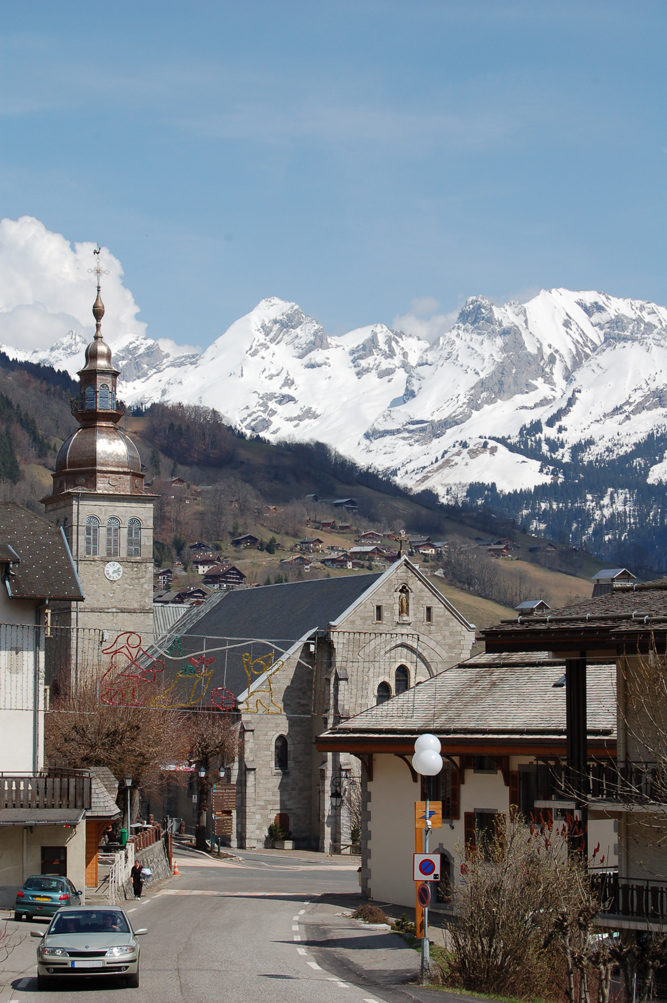
La Clusaz (La Clusaz)

- commune in Haute-Savoie, France
 Hiking in La Clusaz
La Clusaz is a charming alpine village located in the French Alps, known for its skiing in the winter and its stunning hiking trails in the summer. It’s a popular destination for outdoor enthusiasts, offering a variety of hiking experiences suitable for all levels of hikers.
Key Features of Hiking in La Clusaz:
-
Scenic Trails: The area boasts a network of well-marked hiking trails that take you through breathtaking landscapes, including lush meadows, alpine forests, and panoramic mountain views. Trails range from easy walks to more challenging hikes that lead to higher altitudes.
-
Popular Hiking Routes:
- The Col des Aravis: A moderate hike that provides stunning views of Mont Blanc and the surrounding mountains.
- Le Petit Bornand: This trail leads to picturesque villages and offers the chance to see local wildlife and flora.
- Lac des Confins: A beautiful and accessible hike that circles a serene lake, ideal for families and beginners.
-
Wildlife and Flora: While hiking, you may encounter a diverse range of wildlife, including chamois, marmots, and a variety of bird species. The region is also home to many unique alpine plants, particularly during the spring and summer months.
-
Local Guides and Tours: For those who prefer a more guided experience, many local companies offer guided hikes, which can provide insights into the region's ecology, history, and culture.
-
Hiking Essentials: It’s essential to be prepared when hiking in the mountains. Make sure to wear appropriate footwear, carry sufficient water, snacks, and a map or GPS device. Weather conditions can change rapidly, so check forecasts and dress in layers.
-
Accessibility: The start of many hiking trails is accessible by local transport or can be reached by car. Some trails are accessible from La Clusaz directly, allowing for convenience in planning your day.
-
Post-Hike Relaxation: After a day of hiking, the village offers various restaurants and shops where you can enjoy local cuisine and relax.
Best Time to Hike:
The best time for hiking in La Clusaz is typically from late spring to early autumn (May to October), when the weather is more stable and the trails are clear of snow.
Whether you’re a seasoned hiker or a novice looking to explore nature, La Clusaz offers something for everyone. Enjoy your adventure!
- Country:

- Postal Code: 74220
- Coordinates: 45° 54' 15" N, 6° 25' 23" E


- GPS tracks (wikiloc): [Link]
- Area: 40.62 sq km
- Population: 1770
- Web site: http://www.laclusaz.fr
- Wikipedia en: wiki(en)
- Wikipedia: wiki(fr)
- Wikidata storage: Wikidata: Q530721
- Wikipedia Commons Category: [Link]
- Freebase ID: [/m/026dt9_]
- GeoNames ID: Alt: [6457078]
- SIREN number: [217400803]
- BnF ID: [15274339g]
- VIAF ID: Alt: [241843223]
- GND ID: Alt: [4359294-6]
- INSEE municipality code: 74080
Shares border with regions:

Le Grand-Bornand
- commune in Haute-Savoie, France
Hiking in Le Grand-Bornand
Le Grand-Bornand is a picturesque village located in the French Alps, within the Haute-Savoie department. It offers a stunning backdrop of mountains and lush landscapes, making it a popular destination for hiking enthusiasts. Here's what you need to know about hiking in Le Grand-Bornand:...
- Country:
- Postal Code: 74450
- Coordinates: 45° 56' 31" N, 6° 25' 31" E
- GPS tracks (wikiloc): [Link]
- Area: 61.42 sq km
- Population: 2154
- Web site: [Link]


La Giettaz
- commune in Savoie, France
Hiking in La Giettaz
La Giettaz, nestled in the heart of the French Alps, is a charming alpine village that offers a variety of hiking opportunities suitable for walkers of all skill levels. The picturesque scenery, including stunning mountain views, lush valleys, and traditional alpine landscapes, makes it a popular choice for both locals and tourists....
- Country:
- Postal Code: 73590
- Coordinates: 45° 51' 44" N, 6° 29' 43" E
- GPS tracks (wikiloc): [Link]
- Area: 35.2 sq km
- Population: 428


Saint-Jean-de-Sixt
- commune in Haute-Savoie, France
Hiking in Saint-Jean-de-Sixt
Saint-Jean-de-Sixt is a charming village located in the Aravis mountain range in the French Alps, offering a variety of hiking opportunities catering to different experience levels. Here’s what you need to know about hiking in this beautiful area:...
- Country:
- Postal Code: 74450
- Coordinates: 45° 55' 23" N, 6° 24' 36" E
- GPS tracks (wikiloc): [Link]
- Area: 12.21 sq km
- Population: 1433


Thônes
- commune in Haute-Savoie, France
Hiking in Thônes
Thônes is a charming town located in the Haute-Savoie region of the French Alps. It's a great base for hiking enthusiasts, offering stunning mountain scenery, diverse trails, and access to both the Aravis mountain range and the surrounding areas. Here are some highlights about hiking in Thônes:...
- Country:
- Postal Code: 74230
- Coordinates: 45° 52' 56" N, 6° 19' 32" E
- GPS tracks (wikiloc): [Link]
- Area: 52.33 sq km
- Population: 6549
- Web site: [Link]


Manigod
- commune in Haute-Savoie, France
Hiking in Manigod
Manigod is a picturesque alpine village located in the French Alps, specifically in the Haute-Savoie region. It’s well-known for its stunning landscapes, offering breathtaking views of the surrounding mountains, lush greenery, and vibrant meadows. Here are some important aspects to consider when hiking in Manigod:...
- Country:
- Postal Code: 74230
- Coordinates: 45° 51' 39" N, 6° 22' 12" E
- GPS tracks (wikiloc): [Link]
- Area: 44.12 sq km
- Population: 1005
- Web site: [Link]


Les Villards-sur-Thônes
- commune in Haute-Savoie, France
Hiking in Les Villards-sur-Thônes
Les Villards-sur-Thônes is a charming village situated in the Haute-Savoie region of the French Alps. It's an excellent base for hiking enthusiasts due to its scenic landscapes, varied terrain, and proximity to the Aravis Mountain range....
- Country:
- Postal Code: 74230
- Coordinates: 45° 54' 26" N, 6° 21' 57" E
- GPS tracks (wikiloc): [Link]
- Area: 13.32 sq km
- Population: 1038


Sallanches
- commune in Haute-Savoie, France
Hiking in Sallanches
Sallanches, located in the Haute-Savoie region of the French Alps, is an excellent destination for hiking enthusiasts. Nestled between Mont Blanc and the Aravis mountain range, it offers stunning alpine scenery, diverse trails, and opportunities for outdoor activities year-round. Here are some notable aspects of hiking in the Sallanches area:...
- Country:
- Postal Code: 74700
- Coordinates: 45° 56' 11" N, 6° 37' 55" E
- GPS tracks (wikiloc): [Link]
- Area: 65.87 sq km
- Population: 16050
- Web site: [Link]