canton of Villeneuve-sur-Lot-Sud (canton de Villeneuve-sur-Lot-Sud)
- canton of France
- Country:

- Capital: Villeneuve-sur-Lot
- Coordinates: 44° 24' 0" N, 0° 43' 0" E


- GPS tracks (wikiloc): [Link]
- Wikidata storage: Wikidata: Q1727911
- INSEE canton code: [4739]
Includes regions:


Saint-Antoine-de-Ficalba
- commune in Lot-et-Garonne, France
- Country:
- Postal Code: 47340
- Coordinates: 44° 19' 55" N, 0° 42' 58" E
- GPS tracks (wikiloc): [Link]
- Area: 10.93 sq km
- Population: 714

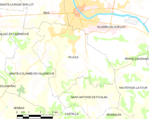
Pujols
- commune in Lot-et-Garonne, France
- Country:
- Postal Code: 47300
- Coordinates: 44° 23' 8" N, 0° 41' 18" E
- GPS tracks (wikiloc): [Link]
- Area: 24.98 sq km
- Population: 3623
- Web site: [Link]
Sembas
- commune in Lot-et-Garonne, France
- Country:
- Postal Code: 47360
- Coordinates: 44° 19' 48" N, 0° 38' 48" E
- GPS tracks (wikiloc): [Link]
- Area: 12.51 sq km
- Population: 138


Sainte-Colombe-de-Villeneuve
- commune in Lot-et-Garonne, France
- Country:
- Postal Code: 47300
- Coordinates: 44° 21' 34" N, 0° 39' 33" E
- GPS tracks (wikiloc): [Link]
- Area: 18.92 sq km
- Population: 496

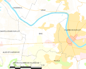
Bias
- commune in Lot-et-Garonne, France
- Country:
- Postal Code: 47300
- Coordinates: 44° 24' 58" N, 0° 40' 9" E
- GPS tracks (wikiloc): [Link]
- Area: 12.29 sq km
- Population: 3062
- Web site: [Link]