canton of Anse (canton d'Anse)

- canton of France
- Country:

- Capital: Anse
- Coordinates: 45° 54' 43" N, 4° 41' 14" E


- GPS tracks (wikiloc): [Link]
- Population: 36896
- Wikipedia en: wiki(en)
- Wikipedia: wiki(fr)
- Wikidata storage: Wikidata: Q1235552
- Library of Congress authority ID: Alt: [n91125629]
- INSEE canton code: [6901]
Includes regions:


Belmont-d'Azergues
- commune in Rhône, France
- Country:
- Postal Code: 69380
- Coordinates: 45° 52' 5" N, 4° 40' 10" E
- GPS tracks (wikiloc): [Link]
- AboveSeaLevel: 300 м m
- Area: 1.51 sq km
- Population: 631


Alix
- commune in Rhône, France
- Country:
- Postal Code: 69380
- Coordinates: 45° 54' 46" N, 4° 39' 15" E
- GPS tracks (wikiloc): [Link]
- Area: 3.61 sq km
- Population: 753
- Web site: [Link]

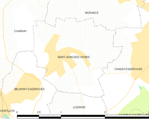
Saint-Jean-des-Vignes
- commune in Rhône, France
- Country:
- Postal Code: 69380
- Coordinates: 45° 52' 33" N, 4° 41' 4" E
- GPS tracks (wikiloc): [Link]
- Area: 2.57 sq km
- Population: 416


Charnay
- commune in Rhône, France
- Country:
- Postal Code: 69380
- Coordinates: 45° 53' 26" N, 4° 40' 6" E
- GPS tracks (wikiloc): [Link]
- Area: 7.06 sq km
- Population: 1067
- Web site: [Link]


Anse
- commune in Rhône, France
- Country:
- Postal Code: 69480
- Coordinates: 45° 56' 8" N, 4° 43' 10" E
- GPS tracks (wikiloc): [Link]
- Area: 15.23 sq km
- Population: 6925
- Web site: [Link]

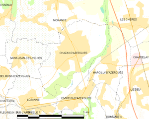
Chazay-d'Azergues
- commune in Rhône, France
- Country:
- Postal Code: 69380
- Coordinates: 45° 52' 33" N, 4° 42' 47" E
- GPS tracks (wikiloc): [Link]
- Area: 5.94 sq km
- Population: 4095
- Web site: [Link]


Lachassagne
- commune in Rhône, France
- Country:
- Postal Code: 69480
- Coordinates: 45° 55' 31" N, 4° 41' 15" E
- GPS tracks (wikiloc): [Link]
- Area: 3.53 sq km
- Population: 1063


Marcy
- commune in Rhône, France
- Country:
- Postal Code: 69480
- Coordinates: 45° 54' 54" N, 4° 40' 54" E
- GPS tracks (wikiloc): [Link]
- Area: 3.33 sq km
- Population: 678
- Web site: [Link]

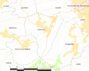
Liergues
- former commune in Rhône, France
- Country:
- Postal Code: 69400
- Coordinates: 45° 58' 11" N, 4° 39' 51" E
- GPS tracks (wikiloc): [Link]
- Area: 5.32 sq km
- Population: 2006

Lucenay
- commune in Rhône, France
- Country:
- Postal Code: 69480
- Coordinates: 45° 54' 46" N, 4° 42' 10" E
- GPS tracks (wikiloc): [Link]
- Area: 6.27 sq km
- Population: 1814
- Web site: [Link]


Pouilly-le-Monial
- former commune in Rhône, France
- Country:
- Postal Code: 69400
- Coordinates: 45° 57' 26" N, 4° 38' 48" E
- GPS tracks (wikiloc): [Link]
- Area: 3.81 sq km
- Population: 990

Pommiers, Rhône
- commune in Rhône, France
- Country:
- Postal Code: 69480
- Coordinates: 45° 57' 19" N, 4° 41' 33" E
- GPS tracks (wikiloc): [Link]
- Area: 7.76 sq km
- Population: 2531
- Web site: [Link]


Morancé
- commune in Rhône, France
- Country:
- Postal Code: 69480
- Coordinates: 45° 53' 53" N, 4° 42' 2" E
- GPS tracks (wikiloc): [Link]
- Area: 9.25 sq km
- Population: 2020
- Web site: [Link]


Ambérieux
- commune in Rhône, France
- Country:
- Postal Code: 69480
- Coordinates: 45° 55' 41" N, 4° 44' 14" E
- GPS tracks (wikiloc): [Link]
- AboveSeaLevel: 176 м m
- Area: 4.55 sq km
- Population: 563