canton of Combles (canton de Combles)
- canton of France (until March 2015)
- Country:

- Capital: Combles
- Coordinates: 50° 0' 36" N, 2° 51' 58" E


- GPS tracks (wikiloc): [Link]
- Wikipedia en: wiki(en)
- Wikipedia: wiki(fr)
- Wikidata storage: Wikidata: Q166921
- Freebase ID: [/m/03y1nln]
- Library of Congress authority ID: Alt: [n2002033969]
- INSEE canton code: [8016]
Includes regions:


Hardecourt-aux-Bois
- commune in Somme, France
- Country:
- Postal Code: 80360
- Coordinates: 49° 59' 23" N, 2° 49' 4" E
- GPS tracks (wikiloc): [Link]
- Area: 5.23 sq km
- Population: 80


Lesbœufs
- commune in Somme, France
- Country:
- Postal Code: 80360
- Coordinates: 50° 2' 32" N, 2° 51' 46" E
- GPS tracks (wikiloc): [Link]
- Area: 5.97 sq km
- Population: 171


Étricourt-Manancourt
- commune in Somme, France
- Country:
- Postal Code: 80360
- Coordinates: 50° 2' 4" N, 2° 59' 7" E
- GPS tracks (wikiloc): [Link]
- Area: 11.02 sq km
- Population: 526
- Web site: [Link]


Flers
- commune in Somme, France
- Country:
- Postal Code: 80360
- Coordinates: 50° 2' 55" N, 2° 49' 17" E
- GPS tracks (wikiloc): [Link]
- Area: 6.27 sq km
- Population: 182


Gueudecourt
- commune in Somme, France
- Country:
- Postal Code: 80360
- Coordinates: 50° 3' 33" N, 2° 50' 33" E
- GPS tracks (wikiloc): [Link]
- Area: 4.87 sq km
- Population: 95


Ginchy
- commune in Somme, France
- Country:
- Postal Code: 80360
- Coordinates: 50° 1' 25" N, 2° 49' 57" E
- GPS tracks (wikiloc): [Link]
- Area: 5.92 sq km
- Population: 63


Longueval
- commune in Somme, France
- Country:
- Postal Code: 80360
- Coordinates: 50° 1' 32" N, 2° 48' 13" E
- GPS tracks (wikiloc): [Link]
- AboveSeaLevel: 150 м m
- Area: 8.53 sq km
- Population: 282


Mesnil-en-Arrouaise
- commune in Somme, France
- Country:
- Postal Code: 80360
- Coordinates: 50° 2' 40" N, 2° 56' 41" E
- GPS tracks (wikiloc): [Link]
- Area: 6.5 sq km
- Population: 134

Maricourt
- commune in Somme, France
- Country:
- Postal Code: 80360
- Coordinates: 49° 58' 50" N, 2° 47' 6" E
- GPS tracks (wikiloc): [Link]
- Area: 7.52 sq km
- Population: 180


Maurepas
- commune in Somme, France
- Country:
- Postal Code: 80360
- Coordinates: 49° 59' 22" N, 2° 50' 49" E
- GPS tracks (wikiloc): [Link]
- Area: 10.88 sq km
- Population: 193


Montauban-de-Picardie
- commune in Somme, France
- Country:
- Postal Code: 80300
- Coordinates: 50° 0' 24" N, 2° 46' 45" E
- GPS tracks (wikiloc): [Link]
- Area: 7.67 sq km
- Population: 237


Carnoy
- commune in Somme, France
- Country:
- Postal Code: 80300
- Coordinates: 49° 59' 4" N, 2° 45' 15" E
- GPS tracks (wikiloc): [Link]
- Area: 3 sq km
- Population: 103


Combles
- commune in Somme, France
- Country:
- Postal Code: 80360
- Coordinates: 50° 0' 34" N, 2° 51' 56" E
- GPS tracks (wikiloc): [Link]
- Area: 9.87 sq km
- Population: 799


Guillemont
- commune in Somme, France
- Country:
- Postal Code: 80360
- Coordinates: 50° 0' 50" N, 2° 49' 29" E
- GPS tracks (wikiloc): [Link]
- Area: 3.27 sq km
- Population: 140


Curlu
- commune in Somme, France
- Country:
- Postal Code: 80360
- Coordinates: 49° 57' 50" N, 2° 48' 59" E
- GPS tracks (wikiloc): [Link]
- Area: 5.89 sq km
- Population: 149


Rancourt
- commune in Somme, France
- Country:
- Postal Code: 80360
- Coordinates: 50° 0' 15" N, 2° 54' 31" E
- GPS tracks (wikiloc): [Link]
- Area: 2.91 sq km
- Population: 204


Sailly-Saillisel
- commune in Somme, France
- Country:
- Postal Code: 80360
- Coordinates: 50° 1' 51" N, 2° 54' 47" E
- GPS tracks (wikiloc): [Link]
- Area: 9.39 sq km
- Population: 473


Hem-Monacu
- commune in Somme, France
- Country:
- Postal Code: 80360
- Coordinates: 49° 57' 18" N, 2° 50' 21" E
- GPS tracks (wikiloc): [Link]
- Area: 3.66 sq km
- Population: 129

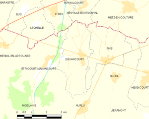
Équancourt
- commune in Somme, France
- Country:
- Postal Code: 80360
- Coordinates: 50° 2' 10" N, 3° 1' 7" E
- GPS tracks (wikiloc): [Link]
- Area: 7.79 sq km
- Population: 296