canton of Coudekerque-Branche (canton de Coudekerque-Branche)

- canton of France
- Country:

- Capital: Coudekerque-Branche
- Coordinates: 51° 1' 10" N, 2° 23' 44" E


- GPS tracks (wikiloc): [Link]
- Population: 49764
- Wikipedia en: wiki(en)
- Wikipedia: wiki(fr)
- Wikidata storage: Wikidata: Q1725070
- INSEE canton code: [5912]
Includes regions:


Coudekerque-Village
- former commune in Nord, France
- Country:
- Postal Code: 59380
- Coordinates: 50° 59' 39" N, 2° 24' 59" E
- GPS tracks (wikiloc): [Link]
- Area: 12.03 sq km
- Population: 1225
- Web site: [Link]


Uxem
- commune in Nord, France
- Country:
- Postal Code: 59229
- Coordinates: 51° 1' 18" N, 2° 29' 0" E
- GPS tracks (wikiloc): [Link]
- Area: 8.27 sq km
- Population: 1410
- Web site: [Link]

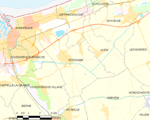
Téteghem-Coudekerque-Village
- commune in Nord, France
- Country:
- Postal Code: 59380; 59229
- Coordinates: 51° 1' 10" N, 2° 26' 41" E
- GPS tracks (wikiloc): [Link]
- Area: 30.44 sq km


Coudekerque-Branche
- commune in Nord, France
- Country:
- Postal Code: 59210
- Coordinates: 51° 1' 29" N, 2° 23' 27" E
- GPS tracks (wikiloc): [Link]
- Area: 9.14 sq km
- Population: 21360
- Web site: [Link]


Bergues
- commune in Nord, France
- Country:
- Postal Code: 59380
- Coordinates: 50° 58' 7" N, 2° 26' 3" E
- GPS tracks (wikiloc): [Link]
- AboveSeaLevel: 22 м m
- Area: 1.32 sq km
- Population: 3805
- Web site: [Link]


Spycker
- commune in Nord, France
- Country:
- Postal Code: 59380
- Coordinates: 50° 58' 10" N, 2° 19' 24" E
- GPS tracks (wikiloc): [Link]
- Area: 9.19 sq km
- Population: 1762
- Web site: [Link]

Armbouts-Cappel
- commune in Nord, France
- Country:
- Postal Code: 59380
- Coordinates: 50° 58' 40" N, 2° 21' 12" E
- GPS tracks (wikiloc): [Link]
- Area: 10.15 sq km
- Population: 2321


Cappelle-la-Grande
- commune in Nord, France
- Country:
- Postal Code: 59180
- Coordinates: 50° 59' 54" N, 2° 21' 51" E
- GPS tracks (wikiloc): [Link]
- Area: 5.46 sq km
- Population: 7903
- Web site: [Link]

Steene
- commune in Nord, France
- Country:
- Postal Code: 59380
- Coordinates: 50° 57' 12" N, 2° 22' 2" E
- GPS tracks (wikiloc): [Link]
- Area: 10.28 sq km
- Population: 1315
- Web site: [Link]


Bierne
- commune in Nord, France
- Country:
- Postal Code: 59380
- Coordinates: 50° 57' 46" N, 2° 24' 39" E
- GPS tracks (wikiloc): [Link]
- Area: 11.04 sq km
- Population: 1804
- Web site: [Link]

Téteghem
- former commune in Nord, France
- Country:
- Postal Code: 59229
- Coordinates: 51° 1' 7" N, 2° 26' 38" E
- GPS tracks (wikiloc): [Link]
- Area: 18.41 sq km
- Population: 6859