canton of Hornoy-le-Bourg (canton de Hornoy-le-Bourg)

- canton of France (until March 2015)
- Country:

- Capital: Hornoy-le-Bourg
- Coordinates: 49° 50' 46" N, 1° 54' 8" E


- GPS tracks (wikiloc): [Link]
- Wikipedia en: wiki(en)
- Wikipedia: wiki(fr)
- Wikidata storage: Wikidata: Q429326
- Freebase ID: [/m/03y6kgy]
- INSEE canton code: [8025]
Includes regions:


Beaucamps-le-Vieux
- commune in Somme, France
- Country:
- Postal Code: 80430
- Coordinates: 49° 50' 39" N, 1° 46' 45" E
- GPS tracks (wikiloc): [Link]
- Area: 5.02 sq km
- Population: 1412

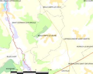
Beaucamps-le-Jeune
- commune in Somme, France
- Country:
- Postal Code: 80430
- Coordinates: 49° 48' 58" N, 1° 46' 19" E
- GPS tracks (wikiloc): [Link]
- Area: 6.72 sq km
- Population: 223


Saint-Germain-sur-Bresle
- commune in Somme, France
- Country:
- Postal Code: 80430
- Coordinates: 49° 49' 50" N, 1° 43' 59" E
- GPS tracks (wikiloc): [Link]
- Area: 8.69 sq km
- Population: 210


Thieulloy-l'Abbaye
- commune in Somme, France
- Country:
- Postal Code: 80126
- Coordinates: 49° 49' 31" N, 1° 56' 41" E
- GPS tracks (wikiloc): [Link]
- Area: 14.66 sq km
- Population: 355


Arguel
- commune in Somme, France
- Country:
- Postal Code: 80140
- Coordinates: 49° 52' 0" N, 1° 48' 6" E
- GPS tracks (wikiloc): [Link]
- Area: 2.54 sq km
- Population: 29


Lafresguimont-Saint-Martin
- commune in Somme, France
- Country:
- Postal Code: 80430
- Coordinates: 49° 48' 55" N, 1° 48' 32" E
- GPS tracks (wikiloc): [Link]
- AboveSeaLevel: 185 м m
- Area: 26.54 sq km
- Population: 533


Méricourt-en-Vimeu
- commune in Somme, France
- Country:
- Postal Code: 80640
- Coordinates: 49° 53' 47" N, 1° 56' 54" E
- GPS tracks (wikiloc): [Link]
- Area: 3.31 sq km
- Population: 102


Aumont
- commune in Somme, France
- Country:
- Postal Code: 80640
- Coordinates: 49° 53' 2" N, 1° 55' 36" E
- GPS tracks (wikiloc): [Link]
- Area: 3.31 sq km
- Population: 137


Liomer
- commune in Somme, France
- Country:
- Postal Code: 80430
- Coordinates: 49° 51' 22" N, 1° 48' 59" E
- GPS tracks (wikiloc): [Link]
- Area: 3.89 sq km
- Population: 403


Le Quesne
- commune in Somme, France
- Country:
- Postal Code: 80430
- Coordinates: 49° 51' 46" N, 1° 47' 54" E
- GPS tracks (wikiloc): [Link]
- Area: 1.43 sq km
- Population: 275


Belloy-Saint-Léonard
- commune in Somme, France
- Country:
- Postal Code: 80270
- Coordinates: 49° 54' 24" N, 1° 54' 13" E
- GPS tracks (wikiloc): [Link]
- Area: 6.55 sq km
- Population: 94


Dromesnil
- commune in Somme, France
- Country:
- Postal Code: 80640
- Coordinates: 49° 52' 48" N, 1° 52' 7" E
- GPS tracks (wikiloc): [Link]
- Area: 5.38 sq km
- Population: 105

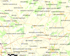
Hornoy-le-Bourg
- commune in Somme, France
- Country:
- Postal Code: 80640
- Coordinates: 49° 50' 44" N, 1° 54' 5" E
- GPS tracks (wikiloc): [Link]
- AboveSeaLevel: 166 м m
- Area: 51.23 sq km
- Population: 1662
- Web site: [Link]

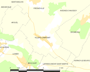
Villers-Campsart
- commune in Somme, France
- Country:
- Postal Code: 80140
- Coordinates: 49° 52' 5" N, 1° 50' 7" E
- GPS tracks (wikiloc): [Link]
- Area: 4.45 sq km
- Population: 153


Brocourt
- commune in Somme, France
- Country:
- Postal Code: 80430
- Coordinates: 49° 51' 11" N, 1° 49' 20" E
- GPS tracks (wikiloc): [Link]
- Area: 2.41 sq km
- Population: 101


Vraignes-lès-Hornoy
- commune in Somme, France
- Country:
- Postal Code: 80640
- Coordinates: 49° 49' 40" N, 1° 54' 37" E
- GPS tracks (wikiloc): [Link]
- Area: 5.65 sq km
- Population: 92