Vraignes-lès-Hornoy (Vraignes-lès-Hornoy)

- commune in Somme, France
- Country:

- Postal Code: 80640
- Coordinates: 49° 49' 40" N, 1° 54' 37" E


- GPS tracks (wikiloc): [Link]
- Area: 5.65 sq km
- Population: 92
- Wikipedia en: wiki(en)
- Wikipedia: wiki(fr)
- Wikidata storage: Wikidata: Q985185
- Wikipedia Commons Category: [Link]
- Freebase ID: [/m/03qmrt0]
- GeoNames ID: Alt: [6444811]
- SIREN number: [218007649]
- VIAF ID: Alt: [310603084]
- PACTOLS thesaurus ID: [pcrtVLyrYG2abm]
- INSEE municipality code: 80813
Shares border with regions:


Thieulloy-l'Abbaye
- commune in Somme, France
- Country:
- Postal Code: 80126
- Coordinates: 49° 49' 31" N, 1° 56' 41" E
- GPS tracks (wikiloc): [Link]
- Area: 14.66 sq km
- Population: 355

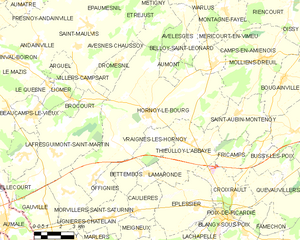
Hornoy-le-Bourg
- commune in Somme, France
- Country:
- Postal Code: 80640
- Coordinates: 49° 50' 44" N, 1° 54' 5" E
- GPS tracks (wikiloc): [Link]
- AboveSeaLevel: 166 м m
- Area: 51.23 sq km
- Population: 1662
- Web site: [Link]


Lamaronde
- commune in Somme, France
- Country:
- Postal Code: 80590
- Coordinates: 49° 48' 19" N, 1° 54' 4" E
- GPS tracks (wikiloc): [Link]
- Area: 2.55 sq km
- Population: 61


Bettembos
- commune in Somme, France
- Country:
- Postal Code: 80590
- Coordinates: 49° 48' 15" N, 1° 52' 47" E
- GPS tracks (wikiloc): [Link]
- Area: 4.16 sq km
- Population: 96