canton of Illiers-Combray (canton d'Illiers-Combray)

- canton of France
- Country:

- Capital: Illiers-Combray
- Coordinates: 48° 20' 19" N, 1° 18' 26" E


- GPS tracks (wikiloc): [Link]
- Population: 26739
- Wikipedia en: wiki(en)
- Wikipedia: wiki(fr)
- Wikidata storage: Wikidata: Q1547780
- OSM relation ID: [4575631]
- Library of Congress authority ID: Alt: [n79074270]
- INSEE canton code: [2811]
Includes regions:


Les Châtelliers-Notre-Dame
- commune in Eure-et-Loir, France
- Country:
- Postal Code: 28120
- Coordinates: 48° 20' 57" N, 1° 12' 15" E
- GPS tracks (wikiloc): [Link]
- AboveSeaLevel: 206 м m
- Area: 10.87 sq km
- Population: 134

Saint-Éman
- commune in Eure-et-Loir, France
- Country:
- Postal Code: 28120
- Coordinates: 48° 19' 19" N, 1° 13' 4" E
- GPS tracks (wikiloc): [Link]
- Area: 4.6 sq km
- Population: 110


La Bourdinière-Saint-Loup
- commune in Eure-et-Loir, France
- Country:
- Postal Code: 28360
- Coordinates: 48° 19' 6" N, 1° 24' 41" E
- GPS tracks (wikiloc): [Link]
- AboveSeaLevel: 155 м m
- Area: 20.16 sq km
- Population: 705


Chuisnes
- commune in Eure-et-Loir, France
- Country:
- Postal Code: 28190
- Coordinates: 48° 26' 50" N, 1° 12' 28" E
- GPS tracks (wikiloc): [Link]
- Area: 22.98 sq km
- Population: 1114


Courville-sur-Eure
- commune in Eure-et-Loir, France
- Country:
- Postal Code: 28190
- Coordinates: 48° 27' 0" N, 1° 14' 25" E
- GPS tracks (wikiloc): [Link]
- Area: 11.13 sq km
- Population: 2810
- Web site: [Link]


Billancelles
- commune in Eure-et-Loir, France
- Country:
- Postal Code: 28190
- Coordinates: 48° 29' 14" N, 1° 12' 54" E
- GPS tracks (wikiloc): [Link]
- Area: 11.95 sq km
- Population: 322
- Web site: [Link]


Cernay
- commune in Eure-et-Loir, France
- Country:
- Postal Code: 28120
- Coordinates: 48° 23' 4" N, 1° 14' 31" E
- GPS tracks (wikiloc): [Link]
- Area: 7.89 sq km
- Population: 88


Blandainville
- commune in Eure-et-Loir, France
- Country:
- Postal Code: 28120
- Coordinates: 48° 18' 30" N, 1° 17' 29" E
- GPS tracks (wikiloc): [Link]
- Area: 13.68 sq km
- Population: 255


Bailleau-le-Pin
- commune in Eure-et-Loir, France
- Country:
- Postal Code: 28120
- Coordinates: 48° 22' 1" N, 1° 19' 48" E
- GPS tracks (wikiloc): [Link]
- Area: 16.54 sq km
- Population: 1572
- Web site: [Link]


Le Favril
- commune in Eure-et-Loir, France
- Country:
- Postal Code: 28190
- Coordinates: 48° 27' 49" N, 1° 7' 43" E
- GPS tracks (wikiloc): [Link]
- AboveSeaLevel: 290 м m
- Area: 23.8 sq km
- Population: 352
- Web site: [Link]


Saint-Germain-le-Gaillard
- commune in Eure-et-Loir, France
- Country:
- Postal Code: 28190
- Coordinates: 48° 25' 18" N, 1° 15' 30" E
- GPS tracks (wikiloc): [Link]
- Area: 8.13 sq km
- Population: 335


Saint-Luperce
- commune in Eure-et-Loir, France
- Country:
- Postal Code: 28190
- Coordinates: 48° 26' 10" N, 1° 18' 58" E
- GPS tracks (wikiloc): [Link]
- Area: 14.35 sq km
- Population: 871
- Web site: [Link]


Sandarville
- commune in Eure-et-Loir, France
- Country:
- Postal Code: 28120
- Coordinates: 48° 20' 52" N, 1° 21' 7" E
- GPS tracks (wikiloc): [Link]
- Area: 9.51 sq km
- Population: 403
- Web site: [Link]


Méréglise
- commune in Eure-et-Loir, France
- Country:
- Postal Code: 28120
- Coordinates: 48° 17' 25" N, 1° 11' 7" E
- GPS tracks (wikiloc): [Link]
- Area: 4.41 sq km
- Population: 102


Pontgouin
- commune in Eure-et-Loir, France
- Country:
- Postal Code: 28190
- Coordinates: 48° 28' 49" N, 1° 9' 40" E
- GPS tracks (wikiloc): [Link]
- Area: 25.16 sq km
- Population: 1125
- Web site: [Link]


Fruncé
- commune in Eure-et-Loir, France
- Country:
- Postal Code: 28190
- Coordinates: 48° 24' 21" N, 1° 13' 27" E
- GPS tracks (wikiloc): [Link]
- Area: 16.97 sq km
- Population: 413
- Web site: [Link]


Dangers
- commune in Eure-et-Loir, France
- Country:
- Postal Code: 28190
- Coordinates: 48° 30' 31" N, 1° 21' 1" E
- GPS tracks (wikiloc): [Link]
- AboveSeaLevel: 202 м m
- Area: 7.39 sq km
- Population: 425


Ermenonville-la-Petite
- commune in Eure-et-Loir, France
- Country:
- Postal Code: 28120
- Coordinates: 48° 17' 46" N, 1° 21' 7" E
- GPS tracks (wikiloc): [Link]
- Area: 5.12 sq km
- Population: 183


Marchéville
- commune in Eure-et-Loir, France
- Country:
- Postal Code: 28120
- Coordinates: 48° 22' 3" N, 1° 15' 8" E
- GPS tracks (wikiloc): [Link]
- Area: 12.38 sq km
- Population: 504
- Web site: [Link]

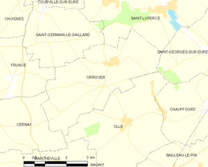
Orrouer
- commune in Eure-et-Loir, France
- Country:
- Postal Code: 28190
- Coordinates: 48° 24' 47" N, 1° 17' 16" E
- GPS tracks (wikiloc): [Link]
- Area: 13.25 sq km
- Population: 303


Magny
- commune in Eure-et-Loir, France
- Country:
- Postal Code: 28120
- Coordinates: 48° 20' 59" N, 1° 15' 47" E
- GPS tracks (wikiloc): [Link]
- Area: 13.03 sq km
- Population: 661


Fontaine-la-Guyon
- commune in Eure-et-Loir, France
- Country:
- Postal Code: 28190
- Coordinates: 48° 28' 19" N, 1° 18' 45" E
- GPS tracks (wikiloc): [Link]
- Area: 14.59 sq km
- Population: 1675
- Web site: [Link]

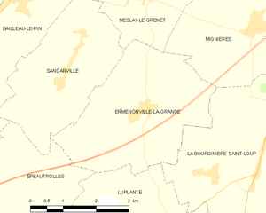
Ermenonville-la-Grande
- commune in Eure-et-Loir, France
- Country:
- Postal Code: 28120
- Coordinates: 48° 20' 11" N, 1° 22' 57" E
- GPS tracks (wikiloc): [Link]
- Area: 12.07 sq km
- Population: 324


Landelles
- commune in Eure-et-Loir, France
- Country:
- Postal Code: 28190
- Coordinates: 48° 28' 5" N, 1° 11' 55" E
- GPS tracks (wikiloc): [Link]
- Area: 10.35 sq km
- Population: 641


Meslay-le-Grenet
- commune in Eure-et-Loir, France
- Country:
- Postal Code: 28120
- Coordinates: 48° 22' 3" N, 1° 22' 57" E
- GPS tracks (wikiloc): [Link]
- Area: 8.94 sq km
- Population: 329


Saint-Arnoult-des-Bois
- commune in Eure-et-Loir, France
- Country:
- Postal Code: 28190
- Coordinates: 48° 29' 33" N, 1° 15' 47" E
- GPS tracks (wikiloc): [Link]
- Area: 20.67 sq km
- Population: 891
- Web site: [Link]


Villebon
- commune in Eure-et-Loir, France
- Country:
- Postal Code: 28190
- Coordinates: 48° 23' 31" N, 1° 12' 25" E
- GPS tracks (wikiloc): [Link]
- Area: 2.16 sq km
- Population: 74


Mittainvilliers-Vérigny
- commune in Eure-et-Loir, France
- Country:
- Postal Code: 28170
- Coordinates: 48° 29' 56" N, 1° 18' 39" E
- GPS tracks (wikiloc): [Link]
- Area: 24.76 sq km

Ollé
- commune in Eure-et-Loir, France
- Country:
- Postal Code: 28120
- Coordinates: 48° 23' 16" N, 1° 17' 49" E
- GPS tracks (wikiloc): [Link]
- Area: 13.12 sq km
- Population: 608


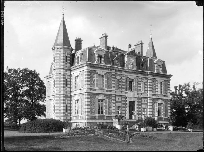
Illiers-Combray
- commune in Eure-et-Loir, France
- Country:
- Postal Code: 28120
- Coordinates: 48° 18' 2" N, 1° 14' 51" E
- GPS tracks (wikiloc): [Link]
- AboveSeaLevel: 162 м m
- Area: 33.6 sq km
- Population: 3333
- Web site: [Link]


Nogent-sur-Eure
- commune in Eure-et-Loir, France
- Country:
- Postal Code: 28120
- Coordinates: 48° 23' 22" N, 1° 21' 45" E
- GPS tracks (wikiloc): [Link]
- Area: 9.22 sq km
- Population: 507


Charonville
- commune in Eure-et-Loir, France
- Country:
- Postal Code: 28120
- Coordinates: 48° 16' 50" N, 1° 18' 14" E
- GPS tracks (wikiloc): [Link]
- Area: 9.66 sq km
- Population: 313
- Web site: [Link]


Saint-Georges-sur-Eure
- commune in Eure-et-Loir, France
- Country:
- Postal Code: 28190
- Coordinates: 48° 25' 3" N, 1° 21' 31" E
- GPS tracks (wikiloc): [Link]
- Area: 15.43 sq km
- Population: 2635
- Web site: [Link]


Saint-Denis-des-Puits
- commune in Eure-et-Loir, France
- Country:
- Postal Code: 28240
- Coordinates: 48° 23' 30" N, 1° 10' 37" E
- GPS tracks (wikiloc): [Link]
- Area: 13.53 sq km
- Population: 141


Chauffours
- commune in Eure-et-Loir, France
- Country:
- Postal Code: 28120
- Coordinates: 48° 23' 43" N, 1° 20' 48" E
- GPS tracks (wikiloc): [Link]
- Area: 7.5 sq km
- Population: 278


Épeautrolles
- commune in Eure-et-Loir, France
- Country:
- Postal Code: 28120
- Coordinates: 48° 18' 40" N, 1° 19' 31" E
- GPS tracks (wikiloc): [Link]
- Area: 9.31 sq km
- Population: 186


Luplanté
- commune in Eure-et-Loir, France
- Country:
- Postal Code: 28360
- Coordinates: 48° 18' 0" N, 1° 23' 56" E
- GPS tracks (wikiloc): [Link]
- Area: 16.65 sq km
- Population: 388