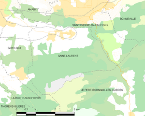
canton of La Roche-sur-Foron (canton de La Roche-sur-Foron)

- canton of France
 Hiking in canton of La Roche-sur-Foron
The Canton of La Roche-sur-Foron, located in the Haute-Savoie department of the Auvergne-Rhône-Alpes region of France, offers a variety of hiking opportunities that cater to different skill levels and preferences. Here are some highlights:
Landscapes and Nature
- Scenic Views: This region provides breathtaking landscapes, including views of the surrounding mountains, valleys, and the Arve River. The area is characterized by its diverse flora and fauna, making it an enjoyable experience for nature lovers.
- Diversity: The canton includes rolling hills, pastures, and forests, offering a variety of terrains to explore.
Hiking Trails
- Well-Marked Paths: Many trails are well-marked and maintained, making it easy for hikers to navigate the routes. Trail markers typically follow the colors of local hiking associations.
- Variety of Trails: There are trails suitable for beginners, intermediate hikers, and even experienced trekkers. Depending on your fitness level and interest, you can choose from short walks to challenging hikes.
Notable Routes
- Les Voirons: A popular area for hiking, with trails that offer panoramic views of Lake Geneva and the Mont Blanc massif. The trails through the Voirons are marked and provide options for various difficulty levels.
- Mont Salève: Although technically located just across the border in Switzerland, Mont Salève is easily accessible and offers numerous hiking trails with incredible views of Geneva and the surrounding countryside.
Local Attractions
- Cultural Sites: Besides the natural beauty, you can also find historical villages and sites in the area. Hiking often offers the opportunity to explore charming towns and experience local culture.
- Wildlife: Keep an eye out for local wildlife, including deer, various birds, and other native species that call the region home.
Practical Tips
- Weather Preparedness: The weather can change rapidly in the mountains, so it’s advisable to check forecasts and come prepared with appropriate clothing and gear.
- Hydration and Snacks: Bring enough water and snacks, especially if planning to hike longer distances. There may be limited access to facilities on some trails.
- Respect Nature: Follow the Leave No Trace principles to keep the trails and environment clean and preserved.
Conclusion
Hiking in the Canton of La Roche-sur-Foron is a rewarding experience filled with stunning natural beauty and varied terrains. Whether you are looking for a leisurely walk or a more challenging hike, this region has something to offer for everyone. Before heading out, make sure to check local trail maps and resources for the most up-to-date information on routes and conditions. Enjoy your hiking adventure!
- Country:

- Capital: La Roche-sur-Foron
- Coordinates: 46° 4' 15" N, 6° 19' 6" E


- GPS tracks (wikiloc): [Link]
- Area: 277.75 sq km
- Population: 52143
- Wikipedia en: wiki(en)
- Wikipedia: wiki(fr)
- Wikidata storage: Wikidata: Q1725652
- INSEE canton code: [7411]
Includes regions:


La Roche-sur-Foron
- commune in Haute-Savoie, France
Hiking in La Roche-sur-Foron
La Roche-sur-Foron, located in the Haute-Savoie region of France, is a beautiful area for hiking enthusiasts. Nestled at the foothills of the Alps, it offers a variety of landscapes, from lush green valleys to rocky trails with breathtaking views of the surrounding mountains....
- Country:
- Postal Code: 74800
- Coordinates: 46° 4' 1" N, 6° 18' 43" E
- GPS tracks (wikiloc): [Link]
- Area: 17.94 sq km
- Population: 11659
- Web site: [Link]


Amancy
- commune in Haute-Savoie, France
Hiking in Amancy
Amancy, located in the Haute-Savoie region of France, is a lesser-known but beautiful destination for hiking enthusiasts. Nestled near the stunning landscapes of the French Alps, it offers a variety of trails that cater to hikers of different skill levels....
- Country:
- Postal Code: 74800
- Coordinates: 46° 4' 27" N, 6° 19' 45" E
- GPS tracks (wikiloc): [Link]
- Area: 8.62 sq km
- Population: 2492
- Web site: [Link]


Saint-Pierre-en-Faucigny
- commune in Haute-Savoie, France
Hiking in Saint-Pierre-en-Faucigny
Saint-Pierre-en-Faucigny is a picturesque commune located in the Haute-Savoie region of France, nestled in the foothills of the French Alps. The area is known for its stunning natural beauty, making it an excellent destination for hiking enthusiasts....
- Country:
- Postal Code: 74800
- Coordinates: 46° 3' 35" N, 6° 22' 21" E
- GPS tracks (wikiloc): [Link]
- Area: 14.91 sq km
- Population: 6241
- Web site: [Link]

Saint-Laurent, Haute-Savoie
- commune in Haute-Savoie, France
Hiking in Saint-Laurent, Haute-Savoie
Hiking in Saint-Laurent, located in the Haute-Savoie region of the French Alps, offers a stunning array of options for outdoor enthusiasts. This area is known for its breathtaking landscapes, charming alpine villages, and diverse trails that cater to hikers of all skill levels....
- Country:
- Postal Code: 74800
- Coordinates: 46° 2' 48" N, 6° 21' 33" E
- GPS tracks (wikiloc): [Link]
- Area: 10.96 sq km
- Population: 818


Arenthon
- commune in Haute-Savoie, France
Hiking in Arenthon
Arenthon, located in the Haute-Savoie region of France, offers beautiful hiking opportunities amidst stunning alpine scenery. The area is characterized by lush green valleys, picturesque lakes, and views of the surrounding mountains, including the Mont Blanc range....
- Country:
- Postal Code: 74800
- Coordinates: 46° 6' 21" N, 6° 19' 58" E
- GPS tracks (wikiloc): [Link]
- Area: 11.47 sq km
- Population: 1606


Cornier
- commune in Haute-Savoie, France
Hiking in Cornier
It seems there might be a small typo in your request, as there isn't a well-known hiking region called "Cornier." However, if you meant "Cornwall," I can provide information about hiking in that area. If there's a different location you were referring to, please let me know!...
- Country:
- Postal Code: 74800
- Coordinates: 46° 5' 34" N, 6° 17' 59" E
- GPS tracks (wikiloc): [Link]
- Area: 6.78 sq km
- Population: 1276
- Web site: [Link]


Etaux
- commune in Haute-Savoie, France
Hiking in Etaux
Etaux is a charming village located in the Haute-Savoie region of the French Alps. It’s a lesser-known destination that offers beautiful landscapes, making it a great spot for hiking enthusiasts. Here are some highlights and tips for hiking in the Etaux area:...
- Country:
- Postal Code: 74800
- Coordinates: 46° 3' 56" N, 6° 17' 38" E
- GPS tracks (wikiloc): [Link]
- Area: 13.69 sq km
- Population: 1913


Saint-Sixt
- commune in Haute-Savoie, France
Hiking in Saint-Sixt
Saint-Sixt is a charming commune located in the Haute-Savoie region of the Auvergne-Rhône-Alpes in southeastern France. It offers a range of hiking opportunities for both beginners and experienced hikers, with stunning landscapes and diverse natural environments to explore. Here are some highlights about hiking in the area:...
- Country:
- Postal Code: 74800
- Coordinates: 46° 3' 10" N, 6° 19' 46" E
- GPS tracks (wikiloc): [Link]
- Area: 5.21 sq km
- Population: 996


La Chapelle-Rambaud
- commune in Haute-Savoie, France
Hiking in La Chapelle-Rambaud
La Chapelle-Rambaud is a picturesque village located in the Auvergne-Rhône-Alpes region of France, known for its stunning natural landscapes and outdoor activities, particularly hiking. Here are some key points to consider if you plan to hike in the area:...
- Country:
- Postal Code: 74800
- Coordinates: 46° 4' 19" N, 6° 14' 24" E
- GPS tracks (wikiloc): [Link]
- Area: 4.27 sq km
- Population: 252
- Web site: [Link]