canton of Andelys (canton des Andelys)

- canton of France
- Country:

- Capital: Les Andelys
- Coordinates: 49° 14' 27" N, 1° 24' 1" E


- GPS tracks (wikiloc): [Link]
- Population: 27554
- Wikipedia en: wiki(en)
- Wikipedia: wiki(fr)
- Wikidata storage: Wikidata: Q1573839
- Freebase ID: [/m/051wnn4]
- INSEE canton code: [2701]
Includes regions:


Le Thuit
- commune in Eure, France
- Country:
- Postal Code: 27700
- Coordinates: 49° 15' 29" N, 1° 21' 32" E
- GPS tracks (wikiloc): [Link]
- Area: 3.02 sq km
- Population: 147

Vatteville
- commune in Eure, France
- Country:
- Postal Code: 27430
- Coordinates: 49° 16' 33" N, 1° 17' 41" E
- GPS tracks (wikiloc): [Link]
- Area: 4.27 sq km
- Population: 185
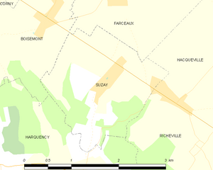
Suzay
- commune in Eure, France
- Country:
- Postal Code: 27420
- Coordinates: 49° 16' 21" N, 1° 30' 58" E
- GPS tracks (wikiloc): [Link]
- Area: 4.11 sq km
- Population: 336

Vézillon
- commune in Eure, France
- Country:
- Postal Code: 27700
- Coordinates: 49° 13' 34" N, 1° 24' 0" E
- GPS tracks (wikiloc): [Link]
- Area: 2.04 sq km
- Population: 263