canton of Neuvy-Saint-Sépulchre (canton de Neuvy-Saint-Sépulchre)

- canton of France
- Country:

- Capital: Neuvy-Saint-Sépulchre
- Coordinates: 46° 35' 49" N, 1° 48' 34" E


- GPS tracks (wikiloc): [Link]
- Population: 15402
- Wikipedia en: wiki(en)
- Wikipedia: wiki(fr)
- Wikidata storage: Wikidata: Q796627
- Wikipedia Commons Category: [Link]
- INSEE canton code: [3611]
Includes regions:

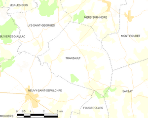
Tranzault
- commune in Indre, France
- Country:
- Postal Code: 36230
- Coordinates: 46° 37' 51" N, 1° 51' 0" E
- GPS tracks (wikiloc): [Link]
- Area: 17.97 sq km
- Population: 347

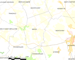
Sarzay
- commune in Indre, France
- Country:
- Postal Code: 36230
- Coordinates: 46° 36' 6" N, 1° 54' 16" E
- GPS tracks (wikiloc): [Link]
- Area: 18.3 sq km
- Population: 319

Montipouret
- commune in Indre, France
- Country:
- Postal Code: 36230
- Coordinates: 46° 38' 58" N, 1° 54' 1" E
- GPS tracks (wikiloc): [Link]
- Area: 27.89 sq km
- Population: 565


Maillet
- commune in Indre, France
- Country:
- Postal Code: 36340
- Coordinates: 46° 34' 24" N, 1° 40' 43" E
- GPS tracks (wikiloc): [Link]
- Area: 25.02 sq km
- Population: 266


Gournay
- commune in Indre, France
- Country:
- Postal Code: 36230
- Coordinates: 46° 34' 59" N, 1° 43' 52" E
- GPS tracks (wikiloc): [Link]
- Area: 20.33 sq km
- Population: 307
- Web site: [Link]


Neuvy-Saint-Sépulchre
- commune in Indre, France
- Country:
- Postal Code: 36230
- Coordinates: 46° 35' 46" N, 1° 48' 31" E
- GPS tracks (wikiloc): [Link]
- AboveSeaLevel: 191 м m
- Area: 35.11 sq km
- Population: 1660

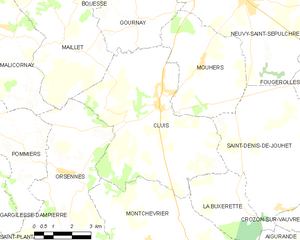
Cluis
- commune in Indre, France
- Country:
- Postal Code: 36340
- Coordinates: 46° 32' 42" N, 1° 44' 55" E
- GPS tracks (wikiloc): [Link]
- Area: 35.32 sq km
- Population: 1000
- Web site: [Link]

Fougerolles
- commune in Indre, France
- Country:
- Postal Code: 36230
- Coordinates: 46° 33' 47" N, 1° 51' 59" E
- GPS tracks (wikiloc): [Link]
- Area: 17.17 sq km
- Population: 343

Lys-Saint-Georges
- commune in Indre, France
- Country:
- Postal Code: 36230
- Coordinates: 46° 38' 31" N, 1° 49' 24" E
- GPS tracks (wikiloc): [Link]
- Area: 12.98 sq km
- Population: 239
- Web site: [Link]


Malicornay
- commune in Indre, France
- Country:
- Postal Code: 36340
- Coordinates: 46° 34' 32" N, 1° 38' 49" E
- GPS tracks (wikiloc): [Link]
- Area: 16.31 sq km
- Population: 185

Mers-sur-Indre
- commune in Indre, France
- Country:
- Postal Code: 36230
- Coordinates: 46° 39' 30" N, 1° 52' 52" E
- GPS tracks (wikiloc): [Link]
- Area: 25.45 sq km
- Population: 655
- Web site: [Link]

Mouhers
- commune in Indre, France
- Country:
- Postal Code: 36340
- Coordinates: 46° 33' 54" N, 1° 46' 39" E
- GPS tracks (wikiloc): [Link]
- Area: 17.89 sq km
- Population: 231