canton of Nogent-le-Rotrou (canton de Nogent-le-Rotrou)

- canton of France
- Country:

- Capital: Nogent-le-Rotrou
- Coordinates: 48° 17' 52" N, 0° 52' 37" E


- GPS tracks (wikiloc): [Link]
- Population: 28747
- Wikipedia en: wiki(en)
- Wikipedia: wiki(fr)
- Wikidata storage: Wikidata: Q1548182
- OSM relation ID: [4575641]
- Library of Congress authority ID: Alt: [n97099842]
- INSEE canton code: [2813]
- ISNI: Alt: [0000 0001 2298 5371]
Includes regions:
Champrond-en-Perchet
- commune in Eure-et-Loir, France
- Country:
- Postal Code: 28400
- Coordinates: 48° 18' 39" N, 0° 52' 6" E
- GPS tracks (wikiloc): [Link]
- AboveSeaLevel: 204 м m
- Area: 9.02 sq km
- Population: 400
- Web site: [Link]


La Gaudaine
- commune in Eure-et-Loir, France
- Country:
- Postal Code: 28400
- Coordinates: 48° 18' 8" N, 0° 55' 46" E
- GPS tracks (wikiloc): [Link]
- Area: 9.19 sq km
- Population: 177
Souancé-au-Perche
- commune in Eure-et-Loir, France
- Country:
- Postal Code: 28400
- Coordinates: 48° 16' 1" N, 0° 51' 17" E
- GPS tracks (wikiloc): [Link]
- Area: 18.94 sq km
- Population: 540

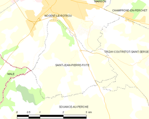
Saint-Jean-Pierre-Fixte
- commune in Eure-et-Loir, France
- Country:
- Postal Code: 28400
- Coordinates: 48° 17' 33" N, 0° 50' 11" E
- GPS tracks (wikiloc): [Link]
- Area: 6.91 sq km
- Population: 263
Argenvilliers
- commune in Eure-et-Loir, France
- Country:
- Postal Code: 28420
- Coordinates: 48° 15' 40" N, 0° 57' 26" E
- GPS tracks (wikiloc): [Link]
- Area: 18.35 sq km
- Population: 341


Nogent-le-Rotrou
- commune in Eure-et-Loir, France
- Country:
- Postal Code: 28400
- Coordinates: 48° 19' 18" N, 0° 49' 18" E
- GPS tracks (wikiloc): [Link]
- AboveSeaLevel: 108 м m
- Area: 23.49 sq km
- Population: 9956
- Web site: [Link]


Vichères
- commune in Eure-et-Loir, France
- Country:
- Postal Code: 28420
- Coordinates: 48° 16' 7" N, 0° 54' 46" E
- GPS tracks (wikiloc): [Link]
- Area: 12.27 sq km
- Population: 319
- Web site: [Link]

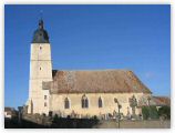
Margon
- commune in Eure-et-Loir, France
- Country:
- Postal Code: 28400
- Coordinates: 48° 20' 8" N, 0° 49' 59" E
- GPS tracks (wikiloc): [Link]
- Area: 12.13 sq km
- Population: 1202
- Web site: [Link]


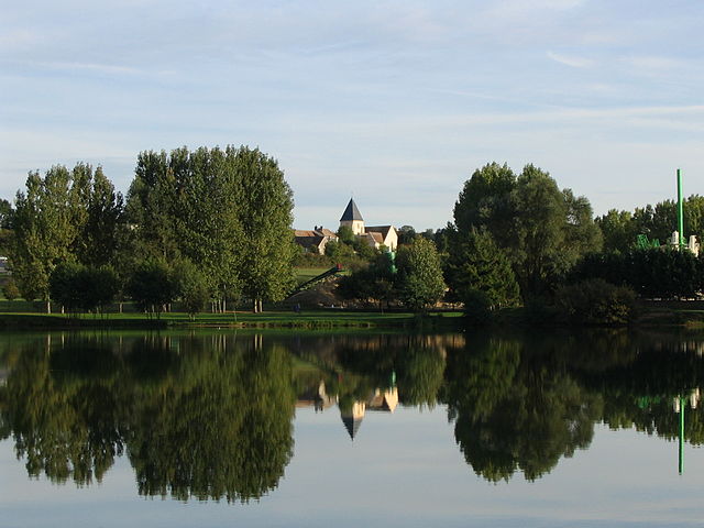
Trizay-Coutretot-Saint-Serge
- commune in Eure-et-Loir, France
- Country:
- Postal Code: 28400
- Coordinates: 48° 17' 34" N, 0° 52' 1" E
- GPS tracks (wikiloc): [Link]
- Area: 11.15 sq km
- Population: 453
- Web site: [Link]

Brunelles
- commune in Eure-et-Loir, France
- Country:
- Postal Code: 28400
- Coordinates: 48° 19' 27" N, 0° 53' 38" E
- GPS tracks (wikiloc): [Link]
- Area: 19.99 sq km
- Population: 566

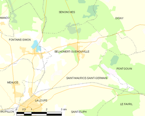
Belhomert-Guéhouville
- commune in Eure-et-Loir, France
- Country:
- Postal Code: 28240
- Coordinates: 48° 30' 15" N, 1° 3' 30" E
- GPS tracks (wikiloc): [Link]
- Area: 10.95 sq km
- Population: 804
- Web site: [Link]