canton of Saint-Nom-la-Bretèche (canton de Saint-Nom-la-Bretèche)

- canton of France
- Country:

- Capital: Saint-Nom-la-Bretèche
- Coordinates: 48° 51' 2" N, 2° 1' 49" E


- GPS tracks (wikiloc): [Link]
- Wikipedia en: wiki(en)
- Wikipedia: wiki(fr)
- Wikidata storage: Wikidata: Q1727288
- Wikipedia Commons Category: [Link]
- Freebase ID: [/m/0gg8vgl]
- INSEE canton code: [7822]
Includes regions:

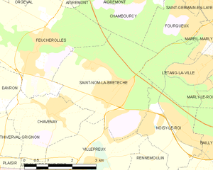
Saint-Nom-la-Bretèche
- commune in Yvelines, France
- Country:
- Postal Code: 78860
- Coordinates: 48° 51' 35" N, 2° 1' 16" E
- GPS tracks (wikiloc): [Link]
- Area: 11.74 sq km
- Population: 4945
- Web site: [Link]


Villepreux
- commune in Yvelines, France
- Country:
- Postal Code: 78450
- Coordinates: 48° 49' 48" N, 2° 0' 8" E
- GPS tracks (wikiloc): [Link]
- Area: 10.4 sq km
- Population: 10000
- Web site: [Link]

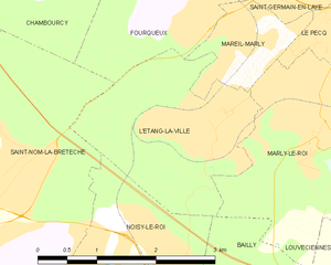
L'Étang-la-Ville
- commune in Yvelines, France
- Country:
- Postal Code: 78620
- Coordinates: 48° 52' 8" N, 2° 4' 16" E
- GPS tracks (wikiloc): [Link]
- AboveSeaLevel: 64 м m
- Area: 5.38 sq km
- Population: 4641
- Web site: [Link]

Noisy-le-Roi
- commune in Yvelines, France
- Country:
- Postal Code: 78590
- Coordinates: 48° 50' 47" N, 2° 3' 36" E
- GPS tracks (wikiloc): [Link]
- Area: 5.43 sq km
- Population: 7550
- Web site: [Link]