canton of Val-de-Reuil (canton de Val-de-Reuil)

- canton of France
- Country:

- Capital: Val-de-Reuil
- Coordinates: 49° 16' 19" N, 1° 12' 47" E


- GPS tracks (wikiloc): [Link]
- Population: 21257
- Wikipedia en: wiki(en)
- Wikipedia: wiki(fr)
- Wikidata storage: Wikidata: Q1727721
- INSEE canton code: [2721]
Includes regions:


Tournedos-sur-Seine
- former commune in Eure, France
- Country:
- Postal Code: 27100
- Coordinates: 49° 16' 27" N, 1° 15' 39" E
- GPS tracks (wikiloc): [Link]
- Area: 6.65 sq km
- Population: 100
- Web site: [Link]

Le Vaudreuil
- commune in Eure, France
- Country:
- Postal Code: 27100
- Coordinates: 49° 15' 23" N, 1° 12' 20" E
- GPS tracks (wikiloc): [Link]
- Area: 14.22 sq km
- Population: 3709
- Web site: [Link]
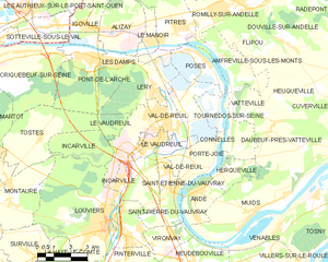
Val-de-Reuil
- commune in Eure, France
- Country:
- Postal Code: 27100
- Coordinates: 49° 16' 26" N, 1° 12' 37" E
- GPS tracks (wikiloc): [Link]
- Area: 25.6 sq km
- Population: 13269
- Web site: [Link]