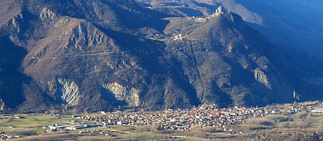
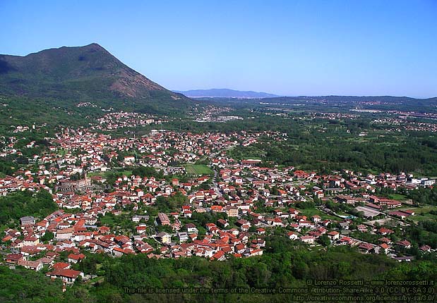
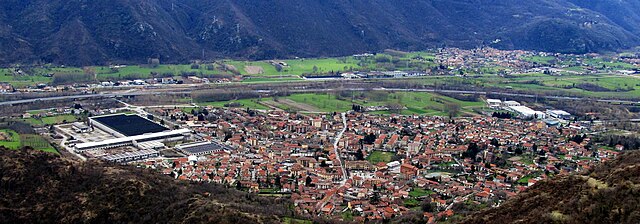
Caprie (Caprie)

- Italian comune
 Hiking in Caprie
Caprie is a charming town located in the Piedmont region of Italy, surrounded by beautiful landscapes and offers various hiking opportunities for outdoor enthusiasts. While it may not be as popular as some other hiking destinations in Italy, it provides a unique experience characterized by its scenic routes, cultural heritage, and relatively less crowded trails.
Hiking in Caprie
-
Scenic Trails: The area around Caprie features a mix of easy to moderate hiking trails, many of which offer stunning views of the Susa Valley and the surrounding mountains. You can expect to encounter picturesque landscapes, lush forests, and possibly some historic sites along the way.
-
Nearby Natural Parks: Caprie’s proximity to the Gran Paradiso National Park and other natural reserves provides additional hiking options. You can explore various trails that lead to lakes, mountain peaks, and wildlife observation areas.
-
Local Flora and Fauna: While hiking, keep an eye out for local wildlife, including deer, birds, and diverse plant species. The region's biodiversity adds to the hiking experience.
-
Cultural Points of Interest: Many trails might lead you through or near historical sites, churches, or quaint villages where you can learn about local culture and history.
-
Accessibility: The trails around Caprie are generally accessible from the town center, making it easy to start your hike without needing extensive travel. Always check local maps for the best routes.
Tips for Hiking in Caprie
- Check Weather Conditions: Always verify the weather before heading out, as conditions can change quickly in the mountains.
- Wear Appropriate Gear: Sturdy hiking shoes, weather-appropriate clothing, and a good backpack are essential.
- Stay Hydrated: Carry enough water, especially on longer hikes. There may not always be water sources along the trails.
- Respect Nature: Follow local guidelines for trail use, stay on marked paths, and carry out all trash.
- Local Guidance: If you're unfamiliar with the area, consider joining a guided hike or checking with local hiking clubs for recommendations and safety tips.
Overall, hiking around Caprie can offer a peaceful escape into nature while allowing you to experience the charm of the Italian countryside!
- Country:

- Postal Code: 10040
- Local Dialing Code: 011
- Licence Plate Code: TO
- Coordinates: 45° 7' 0" N, 7° 19' 0" E


- GPS tracks (wikiloc): [Link]
- AboveSeaLevel: 375 м m
- Area: 16.41 sq km
- Population: 2087
- Web site: http://www.comune.caprie.to.it
- Wikipedia en: wiki(en)
- Wikipedia: wiki(it)
- Wikidata storage: Wikidata: Q9167
- Wikipedia Commons Category: [Link]
- Freebase ID: [/m/0g6tsq]
- GeoNames ID: Alt: [6537264]
- VIAF ID: Alt: [237974935]
- OSM relation ID: [44245]
- TGN ID: [7043667]
- UN/LOCODE: [ITCP6]
- Digital Atlas of the Roman Empire ID: [16199]
- ISTAT ID: 001055
- Italian cadastre code: B705
Shares border with regions:


Rubiana
- Italian comune
Hiking in Rubiana
Rubiana is a charming small village located in the Susa Valley in the Piedmont region of Italy. It is surrounded by the beautiful scenery of the Alps, making it a great destination for hiking enthusiasts. Here are some key points to consider when hiking in and around Rubiana:...
- Country:
- Postal Code: 10040
- Local Dialing Code: 011
- Licence Plate Code: TO
- Coordinates: 45° 8' 0" N, 7° 23' 0" E
- GPS tracks (wikiloc): [Link]
- AboveSeaLevel: 700 м m
- Area: 26.94 sq km
- Population: 2381
- Web site: [Link]
Sant'Ambrogio di Torino
- Italian comune
Hiking in Sant'Ambrogio di Torino
Sant'Ambrogio di Torino, located in the Susa Valley of the Piedmont region in Italy, offers a range of scenic hiking opportunities. The area provides beautiful landscapes, diverse flora and fauna, and a taste of local culture. Here are some highlights and tips for hiking in and around Sant'Ambrogio di Torino:...
- Country:
- Postal Code: 10057
- Local Dialing Code: 011
- Licence Plate Code: TO
- Coordinates: 45° 6' 0" N, 7° 22' 0" E
- GPS tracks (wikiloc): [Link]
- AboveSeaLevel: 356 м m
- Area: 8.37 sq km
- Population: 4735
- Web site: [Link]

Villar Dora
- Italian comune
Hiking in Villar Dora
Villar Dora is a small town located in the Susa Valley in the Piedmont region of northern Italy. It’s surrounded by stunning mountainous landscapes, making it an excellent destination for hiking enthusiasts. Here are some highlights regarding hiking in and around Villar Dora:...
- Country:
- Postal Code: 10040
- Local Dialing Code: 011
- Licence Plate Code: TO
- Coordinates: 45° 7' 0" N, 7° 23' 0" E
- GPS tracks (wikiloc): [Link]
- AboveSeaLevel: 367 м m
- Area: 5.71 sq km
- Population: 2897
- Web site: [Link]


Chiusa di San Michele
- Italian comune
Hiking in Chiusa di San Michele
Chiusa di San Michele, located in the Susa Valley in the Piedmont region of Italy, is a fantastic hiking destination known for its stunning landscapes, historical significance, and diverse trails. The area includes scenic views of the surrounding mountains and valleys, as well as charming villages and rich cultural heritage....
- Country:
- Postal Code: 10050
- Local Dialing Code: 011
- Licence Plate Code: TO
- Coordinates: 45° 6' 0" N, 7° 19' 0" E
- GPS tracks (wikiloc): [Link]
- AboveSeaLevel: 378 м m
- Area: 5.92 sq km
- Population: 1667
- Web site: [Link]

Condove
- Italian comune
Hiking in Condove
Condove is a small town located in the Susa Valley, within the Piedmont region of Italy. It's surrounded by stunning natural scenery, making it a wonderful spot for hiking and outdoor activities. The area is characterized by its picturesque landscapes, including the impressive peaks of the Susa Alps....
- Country:
- Postal Code: 10055
- Local Dialing Code: 011
- Licence Plate Code: TO
- Coordinates: 45° 7' 0" N, 7° 19' 0" E
- GPS tracks (wikiloc): [Link]
- AboveSeaLevel: 376 м m
- Area: 71.11 sq km
- Population: 4614
- Web site: [Link]